Download

1 / 66
670 likes | 1.08k Views
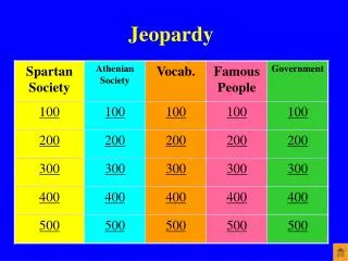
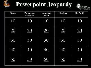
States/Capitals Jeopardy. Choose a category. You will be given the answer. You must give the correct question. Click to begin. Choose a point value. Choose a point value. Click here for Final Jeopardy. Population Density. States & Capitals Northeast. States & Capitals West.

E N D
States/Capitals Jeopardy Choose a category. You will be given the answer. You must give the correct question. Click to begin.
Choose a point value. Choose a point value. Click here for Final Jeopardy
Population Density States & Capitals Northeast States & Capitals West States & Capitals To the South States & Capitals Random What’s the State? 10 Point 10 Point 10 Point 10 Point 10 Point 10 Point 20 Points 20 Points 20 Points 20 Points 20 Points 20 Points 30 Points 30 Points 30 Points 30 Points 30 Points 30 Points 40 Points 40 Points 40 Points 40 Points 40 Points 40 Points 50 Points 50 Points 50 Points 50 Points 50 Points 50 Points
Which state has the highest population? Which has the lowest?
Highest Population: California Lowest Population: Wyoming
Which state has the highest population density? Which state has the lowest population density?
Highest population density: NJ Lowest population density: Alaska
What is the largest state in land area? What is the smallest state in land area?
Largest state in area: Alaska Smallest state in area: Rhode Island
Maine is # 1 Augusta is the capital of Maine
Identify Vermont and New Hampshire by number and tell the capital of each.
Vermont is # 2 Montpelier is the capital New Hampshire is # 3 Concord is the capital
Identify New York, New Jersey & Pennsylvania by their number on the map. Tell the capital of each.
NY: # 5capital: Albany NJ: # 7capital: Trenton Pennsylvania: # 6capital: Harrisburg
Identify Massachusetts, Connecticut, and Rhode Island by their number on the map. Tell the capital of each
Massachusetts: # 4capital: Boston Connecticut: # 9capital: Hartford Rhode Island: # 8capital: Providence
Identify Maryland and Delaware by their numbers on the map. Tell the capital of each.
Maryland: #11capital: Annapolis Delaware: #10capital: Dover
Identify Alaska and Hawaii using their numbers on the map. Tell the capital of each.
Alaska: #39capital: Juneau Hawaii: #38capital: Honolulu
Identify Idaho, Montana, & Wyoming using the numbers on the map. Tell the capital of each.
Idaho: # 44capital: Boise Montana: # 43capital: Helena Wyoming: # 42capital: Cheyenne
Identify Colorado, Utah, and Nevada using the numbers on the map. Tell the capital of each.
Colorado: #41capital: Denver Utah: #45capital: Salt Lake City Nevada: #47capital: Carson City
Identify the 3 western most states on the map and the capital of each. (Hint # 50, 49, & 48)
California(#50)capital: Sacramento Oregon(#49)capital: Salem Washington(#48)capital: Olympia
Tell why the map’s placement of Alaska and Hawaii is not accurate.
The map shows that Alaska is an island next to California, but Alaska is really north of the main land of USA and it borders Canada The map shows Hawaii south of Texas where Mexico is really located. Hawaii is a group of islands in the Pacific Ocean.
Identify Florida by its number on the map. Tell its capital.
1)Georgia- Atlanta 2) Alabama- Montgomery
Identify Texas using its number on the map. Tell the capital.
Find Louisiana and name its capital. What is the trick for remembering Louisiana, Mississippi, Alabama, & Georgia?
Louisiana: #20capital: Baton Rouge Trick: L MAG
Identify Michigan using its number on the map. Tell its capital.
Identify Illinois using its number on the map. Tell the capital.