Download
1 / 1
10 likes | 153 Views
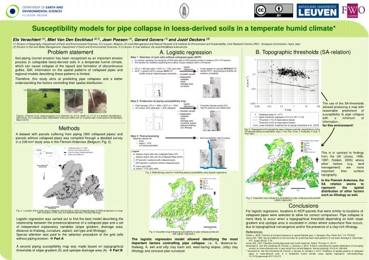
Susceptibility models for pipe collapse in loess-derived soils in a temperate humid climate *. Els Verachtert (1) , Miet Van Den Eeckhaut (2,1) , Jean Poesen (1) , Gerard Govers (1) and Jozef Deckers (3)

E N D
Susceptibility models for pipe collapse in loess-derived soils in a temperate humid climate* • Els Verachtert (1), Miet Van Den Eeckhaut (2,1), Jean Poesen (1), Gerard Govers (1)and Jozef Deckers (3) • Division of Geography, Department of Earth and Environmental Sciences, K.U.Leuven, Belgium; (2) Land Management and Natural Hazards Unit Institute for Environment and Sustainability, Joint Research Centre (JRC) - European Commission, Ispra, Italy; • (3) Division of Soil and Water Management, Department of Earth and Environmental Sciences, K.U.Leuven. E-mail address: els.verachtert@ees.kuleuven.be Problem statement B. Topographic thresholds (SA-relation) A. Logistic regression Soil piping (tunnel erosion) has been recognized as an important erosion process in collapsible loess-derived soils in a temperate humid climate, which can cause collapse of the topsoil and formation of discontinuous gullies. Still, information on the spatial patterns of collapsed pipes and regional models describing these patterns is limited. Therefore, this study aims at predicting pipe collapses and a better understanding the factors controlling their spatial distribution. (a) (b) (c) The use of the SA-thresholds allowed producing a map with reasonable predictions of susceptibility to pipe collapse with a minimum of information… for this environment! Figure 1. Pictures of (a) collapsed pipes (n=3; diameter ca. 0.6 m; depth ca. 0.7 m) in a pasture (Kluisbergen, April 2009), (b) a collapsed pipe (Maarkedal, February 2008) and (c) a typical pipe cross-section (Kluisbergen, March 2010) Methods Fig. 5. Topographical thresholds for pipe collapse used for classification of the SA derived piping susceptibility map (1 very low, 2 low, 3 moderate, 4 high, 5 very high). A dataset with parcels suffering from piping (560 collapsed pipes) and parcels without collapsed pipes was compiled through a detailed survey in a 236 km² study area in the Flemish Ardennes (Belgium; Fig. 2). This is in contrast to findings from the UK (Jones, 1986, 1997; Holden, 2005) where other factors (e.g. land management) are more important than surface topography. In the Flemish Ardennes, the SA relation seems to represent the spatial distribution of other factors such as lithology as well. Fig. 3. Methodology used for modelling piping susceptibility using logistic regression. Fig. 6. Classified map indicating susceptibility to pipe collapse produced with logistic regression. Conclusions For logistic regression, locations in NCP-parcels that were similar to locations of collapsed pipes were selected to allow for correct comparison.Pipe collapse is more likely to occur when a topographical threshold depending on both slope gradient and upslope area is exceeded in zones where subsurface flow occurs, due to topographical convergence and/or the presence of a clay-rich lithology. Fig. 2. Location of the study area in Belgium and inventory of the collapsed pipes (n=560) projected on a map with indication of the clay-rich Aalbeke Member (Tertiary lithology). Logistic regression was carried out to find the best model describing the relationship between the presence/absence of a collapsed pipe and a set of independent explanatory variables (slope gradient, drainage area, distance-to-thalweg, curvature, aspect, soil type and lithology). Special attention was paid to the selection procedure of the grid cells without piping erosion. Part A A second piping susceptibility map was made based on topographical thresholds of slope gradient (S) and upslope drainage area (A). Part B References Holden J. 2005. Controls of soil pipe frequency in upland blanket peat. J. Geophys. Res. Earth Surf. 110, F01002. Jones JAA. 1986. Some limitations to the a/s index for predicting basin-wide patterns of soil water drainage.Z. Geomorph. N.F., Suppl.-Bd 60, 7-20. Jones JAA. 1997. Pipeflow contributing areas and runoff response. Hydrol. Process.11, 35-41. Verachtert E, Van Den Eeckhaut M, Poesen, J, Deckers J. 2010. Factors controlling the spatial distribution of soil piping erosion on loess-derived soils: a case study from central Belgium. Geomorphology 118 (3-4), 339-348. * Verachtert E, Van Den Eeckhaut M, Poesen J, Govers G, Deckers J. 2011. Prediction of spatial patterns of collapsed pipes in loess-derived soils in a temperate humid climate using logistic regression. Geomorphology,10.1016/j.geomorph.2011.03.015 Fig. 4. Classified map indicating susceptibility to pipe collapse produced with logistic regression. The logistic regression model allowed identifying the most important factors controlling pipe collapse: i.e. S, distance-to-thalweg, A, wet and silty clay loam soil, west-facing slopes, (silty) clay lithology and concave plan curvature.