Download
1 / 20
200 likes | 342 Views
Near real time VTEC estimation using La Plata Ionospheric Model. M. Gende 1 , C. Brunini 1 , C. Valladares 2 Universidad Nacional de La Plata, Argentina 1 Boston College, USA 2. Outlook. LISN Project SIRGAS-ION LPIM model Near real time data Conclusions and future work.

E N D
Near real time VTEC estimation using La Plata Ionospheric Model M. Gende1, C. Brunini1, C. Valladares2 Universidad Nacional de La Plata, Argentina1 Boston College, USA 2 IAG Scientific Assembly: Geodesy For Planet Earth.
Outlook • LISN Project • SIRGAS-ION • LPIM model • Near real time data • Conclusions and future work IAG Scientific Assembly: Geodesy For Planet Earth.
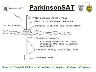
The actual state of the Argentinean component of the LISN project IAG Scientific Assembly: Geodesy For Planet Earth.
LISN • Low-latitude Ionospheric Sensor Network • Distributed multi-instrumental observatory • Monitoring and predicting the equatorial ionosphere IAG Scientific Assembly: Geodesy For Planet Earth.
Instruments • 70 GPS receivers (modified firmware) • 5 flux gate magnetometers • 5 ionospheric sensors IAG Scientific Assembly: Geodesy For Planet Earth.
GPS IAG Scientific Assembly: Geodesy For Planet Earth.
GPS IAG Scientific Assembly: Geodesy For Planet Earth.
Magnetometer IAG Scientific Assembly: Geodesy For Planet Earth.
Ionospheric sensor IAG Scientific Assembly: Geodesy For Planet Earth.
SIRGAS-ION IAG Scientific Assembly: Geodesy For Planet Earth.
Stations for regional maps IAG Scientific Assembly: Geodesy For Planet Earth.
http://cplat.fcaglp.unlp.edu.ar/iono/us/index.shtml IAG Scientific Assembly: Geodesy For Planet Earth.
LPIM model • Pre-processing • Calibration • Interpolation IAG Scientific Assembly: Geodesy For Planet Earth.
Corrientes IAG Scientific Assembly: Geodesy For Planet Earth.
Corrientes IAG Scientific Assembly: Geodesy For Planet Earth.
Conclusions • A set of instruments were installed in the frame of the LISN project • Part of LPIM routines were used to compute VTEC with a delay of 5 minutes • A prototype platform for future services IAG Scientific Assembly: Geodesy For Planet Earth.
Future Works • Modify LPIM to accept NTRIP data format as input • Include more stations so a regional interpolation can be done IAG Scientific Assembly: Geodesy For Planet Earth.