Download
1 / 31
310 likes | 593 Views
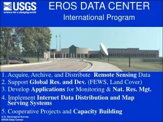
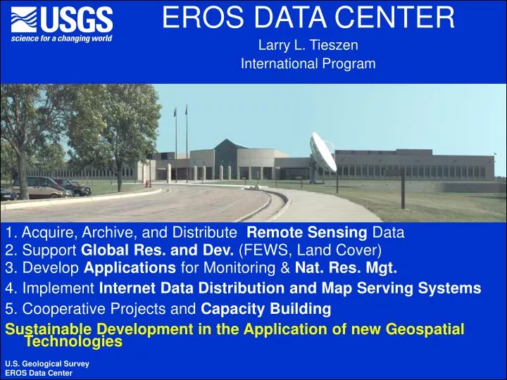
EROS DATA CENTER Larry L. Tieszen International Program. 1. Acquire, Archive, and Distribute Remote Sensing Data 2. Support Global Res. and Dev. (FEWS, Land Cover) 3. Develop Applications for Monitoring & Nat. Res. Mgt. 4. Implement Internet Data Distribution and Map Serving Systems

E N D
EROS DATA CENTER Larry L. Tieszen International Program 1. Acquire, Archive, and Distribute Remote Sensing Data 2. Support Global Res. and Dev. (FEWS, Land Cover) 3. Develop Applications for Monitoring & Nat. Res. Mgt. 4. Implement Internet Data Distribution and Map Serving Systems 5. Cooperative Projects and Capacity Building Sustainable Development in the Application of new Geospatial Technologies U.S. Geological Survey EROS Data Center
A Mesoamerican and Caribbean Geospatial Alliance (MACGA) Larry L. Tieszen (tieszen@usgs.gov) International Programs, U.S.Geological Survey/EROS Data Center “Use of Geo-Spatial Technology for Sustainable Development in the Caribbean” St. Vincent & the Grenadines 18 March, 2004 SPECIAL THANK YOU -Honorable Minister -Caribbean Officials -IACD &USD of OAS (Jan Vermeiren) -OFDA/USAID (Julie Leonard) -CDERA (Liz Riley) -USSouthcom (Earnie Paylor) -UWI (Jacob Opadeyi) -ESRI, NASA, NGA, WRI, +
Mesoamerican and Caribbean Geospatial Alliance (MACGA) Overall Goals for MACGA(Mesoamerica and Caribbean: • Facilitate Regionally Consistent Geospatial Data Development, Access, Dissemination; • Support Applications; • Achieve Development Objectives; and • Secure Access to Data and Resources • Software, • Source Data, • Technical Specialists • Derived Project or other Data • Regional Network, Users Group, Specialists • Stimulate Planning, Cooperation, and Integration
MACGA Caribbean: Specific Activities & Objectives • Provide capacity-building and technical assistance in geospatial technologies. • Facilitate the implementation of GIS Web Services in each MAC country. • Promote the development of public domain digital core data sets • Promote appropriate use of common standards and methods in spatial data production, cataloguing, and dissemination. • Strengthen existing SDIs and cataloguing systems, and foster the establishment of new ones. • Help establish a network of GIS peers in the region for professional support and development. • Foster harmonization and integration of spatial data sets in the region.
MACGA Presents Trasforming Technologies as Public Goods: • The Premise: • We are in the midst of developing Transforming Technologies • Potential to support significant sustainable development • What are these Transforming Technologies?: • Remote Sensing in near real-time as a “Public Good,” • GPS and related developments and capabilities, • GIS tools, models, and decision aids that are web-based, • Facile use of the Internet for access to data, information, understanding, and commercial transactions. • The Hope….: • The Concern….:
MACGA Presents Trasforming Technologies as Public Goods: • The Premise: • We are in the midst of developing Transforming Technologies • Potential to support significant sustainable development • What are these Transforming Technologies?: • The Hope….:The advent of on-line internet services, e.g., data access, internet map serving, querying, analyses and simulations, and even commerce has the potential to distribute the benefits of the technology equitably across countries and out of the domain of technical gurus. However, this potential widespread application will depend upon ready access to meaningful data and information that is user friendly, available at nearly any time, and accessible in nearly any place. Such a widespread spatial data infrastructure (SDI) is a public good. • The Concern….:
MACGA Presents Trasforming Technologies as Public Goods: • The Premise: • We are in the midst of developing Transforming Technologies • Potential to support significant sustainable development • What are these Transforming Technologies?: • The Hope….: • The Concern….: Although many have suggested that we now live in a global information economy, it is not clear that the advantages of this global information economy are readily available to the developing world – nor for that matter, that the integration and coordination of these technologies in development strategies or projects is adequate or even seen as a priority.
Vision: A Paradigm for a “Functional Global Data Infrastructure.”(How does the Caribbean Build One?) Geography GeoNetwork Carib.net CIESIN Network Portals, Projects, and Programs FEWS CPACC CDERA Modeling, Applicatio n , and Querying Standards, Tools Interfaces, Data models, Metadata Clearinghouse Operational Access & Discovery Services agreements Data Sources & Core Data (This is “a Browser and The Internet accessing and producing data, information, and understanding - and supporting transactions”) Adapted from Doug Nebert, Global Spatial Data Infrastructure Secretariat, 2001.
A Little History: Results of Mitch Disaster Evaluation Meeting of IDB/SICA(CCAD), San Salvador • Disasters were common to all countries and recurring, • Disasters were partly man-made, trans-boundary, • Need for data and information, • Need for ready access to data, • Request for Clearinghouse and Data Distribution Support, • Need for Data Integration, and • Desire to cooperate and integrate = Regional (Hurricane Georges, recent flooding/landslides, and flooding impacts on food security in Haiti suggest similar needs in the Caribbean.)
Can We Meet the Challenge of These Great Opportunities for Spatial Data Applications in the Caribbean?? • Share our interests and capabilities, • Identify our needs, • Plan to cooperate and integrate for mutual benefit, • Realize the Special Roles & Contributions, • Continue a Broad Plan for the Future • Establish the Caribbean as a Model for Regional Development, especially small island nations • Exploit need and current emphasis on Vulnerability Assessment, Risk Reduction, and Disaster Preparedness. My Challenge to all of us:
Main Alliance Partners in the Caribbean • U.S. Southern Command (USSOUTHCOM), Pacific Disaster Center • UNEP-GRID Sioux Falls • Pan American Health Organization (PAHO) • UNOOSA • The Pan-American Institute for Geography and History (PAIGH) • C. A. Commission for Environment and Development (CCAD) • Permanent Committee for the American Spatial Data Infrastructure (CP-IDEA) • Academy for Educational Development (AED) • Global Spatial Development Infrastructure (GSDI) • Food and Ag. Organization (FAO and LADA) • USAID/GDA, OFDA, LAC • USGS/EROS Data Center • Caribbean Disaster Emergency Response Agency (CDERA) & supporters • Organization of American States (OAS) • University of the West Indies (UWI), Center for Geospatial Studies • Caribbean Development Bank • National Geospatial-Intelligence Agency (NGA, formerly NIMA) • ESRI • (Ministries of environment , agriculture, coffee agencies and mapping agencies in the Caribbean) • NOAA – Geodetic Systems
Capacity-building Workshops, Planning Meetings, and follow-on Projects • Two workshops on geospatial technologies: one for Mesoamerican (completed) and one for the Caribbean • 30 participants from Mesoamerica and 30 from the Caribbean • Donation of GIS software to some participating agencies. • Provision of spatial data sets and information (e.g., Landsat data, SRTM data) • 2 day seminars for senior management to plan MACGA activities: one for Mesoamerica and one for the Caribbean • Identify & initiate Projects MACGA workshop participants in Panama MACGA Planning Meeting Panama
The Next Steps:MACGA Caribbean Capacity Building Workshop • Where: • University of West Indies, Trinidad • Jacob Opadeyi, facility coordinator (jopadeyi@hotmail.com) • Dates: • May 16-28, 2004 • Participants: • 30 Trainees from CARICOM countries • Technical requirements (defined by Opadeyi and others) • GIS capabilities • National mapping/disaster planning/ or related agencies • Selection & Invitation • MACGA Organizing Committee • OAS, CDERA, National Ministers • Support Provided to Invitees • Travel, per diem, and all associated facilities/workshop costs
The Next Steps:MACGA Caribbean Capacity Building Workshop Agenda • Training • ArcGIS • ArcIMS (& Public Domain Internet map servers) • ESRI cartographic tools and methodologies to develop Global Map products • Use of SRTM elevation data (30m and 90m resolution) • New tools and methods for spatial data cataloguing and Clearinghouse implementation • Geodetic Controls in the Caribbean • (Use of new sensor data (e.g., MODIS, ASTER)) • Other related to vulnerability analysis, risk reduction, and disaster management • National and Facilitator Presentations each day
The Next Steps:MACGA Caribbean Capacity Building Workshop Agenda (continued) • Software Distributed • ArcGIS, ArcIMS, SDE, and related ESRI products as required and as capacity allows to select agencies • Public Domain Internet map servers • Clearinghouse and Metadata software • Data Distributed • “Earthsat Geocover” for each island • 1975, 1990, 2000 TM georectified sets • GOFC CarLand TM+ data for Caribbean Land Cover • 2002 • SRTM 90m elevation data • “Miscellaneous”
The Next Steps:MACGA Caribbean Capacity Building Workshop Agenda (continued) • Implementations Initiated • National Integrated data sets for IMS presenting vulnerability and disaster planning data • IMS for Caribbean Land Cover and ancillary data products • Data Catalogues and Clearinghouses • (IDSS systems) • LAC-SDI Newsletter
The Next Steps:MACGA Caribbean Planning Meeting • Where: • University of West Indies, Trinidad • Jacob Opadeyi, facility coordinator (jopadeyi@hotmail.com) • Dates: • May 27-28, 2004 (Concurrent with end of Capacity Building) • Participants (invitation to all with vested interests): • Donors, Projects, Organizations, Regional and National Agencies, NGOs, and others • Facilities are provided • Each participant covers own travel and per diem • Outcome • Future cooperation, • Plans for capacity building, national and regional • Continued MACGA support and project development
Selected Activities already Initiated and to be Developed • Topographic Data/derived producgts • Vulnerability Mapping, • FEWS Products, Early Warning • Disaster Preparedness, IDSS • IMS ex: Specialty Coffee/bananas • SDI-LAC Newsletter • Earthsat Geocover • CarLand Caribbean Land Cover IMS • Clearninghouse & Metadata
1975 1990 2000 Caribbean Data Holdings, Earthsat Geocover USGS/EDC will complete the accessions and provide at the Training Workshop
Land Cover & Sustainable Development A Regional Project for Caribbean-Wide National and Regional Integrated Database Applications-Conservation, Forestry, Ag-Environmental Protection-Land Use Planning-Disaster Mitigation-Climate Change and Mitigation-Parcel/Commodity Certification Remote Sensing, Consistent Land Cover/Use, Integrated Core Databases, and Internet Map Servers
Integrated Land Cover/Use System for the Caribbean Islands DEM Soil + Climate Other Soil + Other Imagery Soil + Other DEM + Decision Tree Training of Complete Data Set Field Refinement Documented and Adaptable Land Classification Small Grain Barren Sedge Wetland Indus- trial Shrub Grass Montane Forest Internet Map Server Applications for Diverse Clients Source Data and Rules for Specific Client Applications IMS Implementation
CarLand: Caribbean Land Cover and Data Integration in Internet Map Servers
2.1Spatial Data Development, Access, and Distribution – Geospatial Data Clearinghouses • Structured Metadata, Internet Based, Distributed Nodes • Global or Specified Simultaneous Searches • Systematic Data Retrieval and Organization Nodes in the “Caribbean” Major Projects: -IGDN -Mitch Reconstruction Supported by: USAID, IDB, OAS-PAIGH, CIDA, (World Bank, CIAT)
Stream Flow Model Data Output / Decision Support System Preprocessing RFE MAP Water Balance QPF MAE Basin PET Lumped Routing Linkage Soil Routing Parameters Flood Inundation Mapping LU/LC Dist. Routing Soil Parameters DEM Updating Landsat 7 SPOT FEWS Flood Risk Monitoring System Flow Diagram
When MACGA Objectives are Implemented...... • Spatial data is commonly used to assist decision-making. • Easy data access is commonplace. • Basic national and regional digital data sets are available for a nominal cost or free. • A wide range of map services is available on the Web. • Any user is able to view and analyze data without the use of specialized software. • Duplication of effort in data creation is minimal. • All new data are catalogued and incorporated into on-line catalogs. • Data development follows common standards and guidelines. • Governments encourage data production and use. • MACGA has supported multi-sectoral needs: land use planning, conservation/biodiversity, disaster mitigation/planning, early warning, transportation, communications, and other infrastructure.
What can we do Today to Facilitate Common Objectives • Help identify your specific needs and requirements, • Assist in the identification of best participants, • Consider participation in the MACGA Planning Meeting, • Help define national regional needs for the national, project, and regional donors, • Identify other opportunities we can make, • Provide enthusiastic support for your national participants in the Training and Planning meetings.
Agencies/Trainees Receive Training in Developing Integrated Databases, Commercial and Public Internet Map Servers • Data will be integrated and incorporated in operational servers • Software will be provided to each country. • Disaster related spatial data can be integrated by “teams” from each country. • Servers can be established for a wide variety of applications and with various levels of protection. • Provides powerful access to users who are not GIS specialists. • Requires data in useful and compatible format with appropriate standards, datums, projections, etc. • Integrates a broad array of projects in the Caribbean. • Following slides present a very, very simple example for Barbados.
Deliverables MACGA facilitates (1) Integration of cadastral and municipal data setsSome data can be open to the public through GIS Web Services and multi-viewers Biodiversity and Environmental Geographic Web Services. To be developed by the national environmental agencies, in support of initiatives such as SIAM and IABIN Coffee IMS applications to support coffee marketing and certification To be developed by agricultural agencies in Central America and the Dominican Republic.
Deliverables MACGA Facilitates (2) Evaluation and integration of existing data sets and applicationsUtilizing common standards and methodologies. Implementation of Clearinghouse nodes and data cataloguingStrengthen existing nodes and help create new ones GIS and remote sensing network of peersThey implement permanent communication channels, circulate news, and provide technical assistance to members OTHERS:Follow-up seminars, support to NSDI initiatives, establishment of standards, data dissemination, spatial data integration.
The Mesoamerican and Caribbean Geospatial Alliance (MACGA) thanks youLarry L. Tieszen tieszen@usgs.gov MACGA Caribbean Capacity Building Workshop May 16-28, 2004 UWI, Trinidad MACGA Caribbean Planning Meeting May 27-28, 2004 UWI, Trinidad U.S. Geological Survey EROS Data Center