Download
1 / 10
100 likes | 101 Views
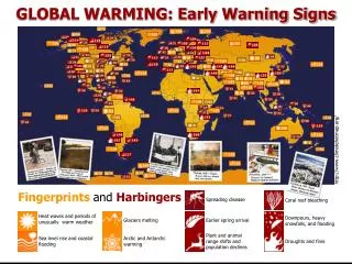
A system that collects and analyzes weather data to produce daily early warning maps for wildland fire danger. It aims to mitigate the hazards caused by wildfires and prevent damage to ecosystems, agriculture, and human life.

E N D
Fire Danger mapsTypical data flow 2. Transfer data 1. Collect noon weather observations from WMO centres 3. Extract and decode weather data; interpolate conditions to build grid layers in a GIS; produce daily early warning maps 4. Map products displaying current fire danger are distributed via WWW and GEONETCast Terrain and Vegetation characteristics
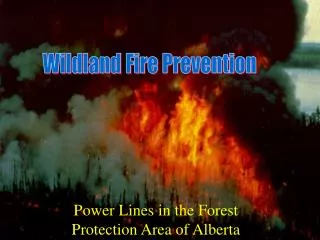
Why a Wildland FireEarly Warning ? Wildand Fire is a Global Source of Multiple Hazards • Significant Ecosystem damage • Degradation in forest/grassland health due to uncontrolled burning • Agriculture and land degradation with losses in production • Hydrological changes resulting in desertification and flooding • Significant loss of life, including negative societal impact • and economic losses • Losses and vulnerability at urban-rural interface increasing • Global health impact due to smoke and emissions • Disruption of transport due to changes in visibility • Costly fire suppression programs • Potential impact on climate change • Global carbon cycle impact
Reference initiative UN-ISDR initiative “Global Wildland Fire Network” and will consider as planning reference the project “Global Early Warning System for Wildland Fire”, presented at EWC III in Bonn, March 2006 by a consortium including • Global Fire Monitoring Center (GFMC), Max Planck Institute for Chemistry, c/o Freiburg University / United Nations University, Germany on behalf of the UNISDR Wildland Fire Advisory Group / Global Wildland Fire Network • Canadian Forest Service (CFS), Edmonton, Canada • Bushfire CRC, Australia • Global Observation of Forest and Land Cover Dynamics (GOFC-GOLD) Secretariat, Edmonton, Canada • University of Maryland (UMD), USA • World Meteorological Organization (WMO) • World Weather Research Programme (WWRP) • Bureau of Meteorology Research Centre (BMRC), Melbourne, Australia • European Centre for Medium Range Weather Forecasting (ECMWF) • Instituto Nacional de Meteorologia, Spain • Finnish Meteorological Institute, Finland • MetOffice, UK
Objectives • Objectives • To develop a global early warning system for wildland fire based on existing • and demonstrated science and technologies. • To develop an information network to quickly disseminate early warning of wildland fire danger that reaches global to local communities. • To develop an historical record of global fire danger information for early warning product enhancement, validation and strategic planning purposes. • To design and implement a technology transfer program to provide training for global, regional, national, and local community applications in: • a) early warning system operation, • b) methods for local to global calibration of the System, and • c) using the System for prevention, preparedness, detection, and fire response decision-making.
Activities Task DI-06-13Participants • Co-leaders • Johann Goldammer task point of Contact • ISDR/GFMC (Global Fire Monitoring Center) • Michael Brady, Canadian Forest Service, representing • GOFC-GOLD (Global Observation for Forest and Land Cover Dynamics • Joao Costa • INOV (Instituto de Novas Tecnologias ) Portugal • Contributors include WMO and organizations in the following Countries: • Australia • Canada • Japan • Portugal • Rep. of Korea • South Africa • Thailand • USA
Activities scheduled for 2007 The schedule of activities foresees definition of the Global System and its implementation by progressive inclusion of regional/national systems, that are today at different stages of design and implementation. GEO focus will be to support definition and implementation activities in regions where identified gaps to have the system in place are higher. The GFMC website - http://www.fire.uni-freiburg.de/ - is periodically updated with all the progressive contributions.
Activities flow Regional System Definition Regional System Review Prototype Development Prototype operations Production Scenario Definition Distribution Scenario Definition Summit GEONETCast Planning
Key Milestones table 2007 NOTE The prototype will be presented and reviewed during a dedicated workshop scheduled for 29-31 October in Accra, Ghana
Deliverables for the Summit • Production and dissemination of Daily Fire Danger maps over Africa. • Use of GEONETCast for product dissemination. There is an option still open to develop the product also for SE and Central Asia – discussions are on going with Sentinel Asia. Initial feasibility assessment No show stoppers identified from a technical point of view. Discussions on going to finalize the support that key players will give to the development of the prototype and to a pre-operational phase.