Download
1 / 26
260 likes | 377 Views
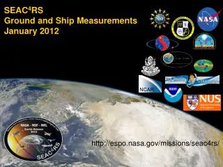
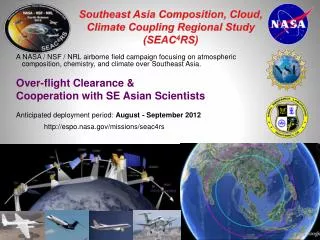
SEAC 4 RS Ground and Ship Measurements February 2012. NCAR. http://espo.nasa.gov/missions/seac4rs/. Surface Network Bottom Line Up Front.

E N D
SEAC4RSGround and Ship MeasurementsFebruary 2012 NCAR http://espo.nasa.gov/missions/seac4rs/
Surface NetworkBottom Line Up Front • Because of metrological complexity & political sensitivities in SE Asia, data from a ground network is required to meet SEAC4RS science and verification goals. • Backbone is the AERONET, AERONET-MAN, MPLNET, SHADOZ and NRL supersites and R/V. • All SEAC4RS ground components have field history with 7SEAS and SHADOZ in the region with established partners. • There are few total “unknowns” but we expect the deployment to be fairly “fluid” in nature. • Over flight would be appreciated, but not expected. But, science success will require combining surface and airborne data (discussions tomorrow). • There is still room to accommodate needs of the science team, including the deployment of additional instrumentation or personnel-particularly at supersites and at sea.
Ground Network Components Start with these POCs • AERONET/MAN: Brent Holben (brent.n.holben@nasa.gov) • 20 Long term+7 Temporary • 5 ferry lines to be manned with microtops for MAN • MPLNET: Judd Welton (ellsworth.j.welton@nasa.gov) • 4 Long term MPLs +5 Temporary Leosphere ALS sites. • SHADOZ Ozonesondes(daily): AnneThompson (anne@atmos.psu.edu) • 3 Long term+ 4/6 temporary* • Cryogenic Frostpoint Hygrometer Sondes: RennieSelkirk (henry.selkirk@nasa.gov) • Utapao (20 releases w/SHADOZ) • Nepal sites: Arnico Panday, Arnico (akp5x@eservices.virginia.edu) • BC, CO, ozone, sometimes AERONET and SHADOZ • VASCO Jeffrey Reid and HafJonsson (hjonsson@nps.navy.mil). • Singapore Super Site: Jeffrey Reid (jeffrey.reid@nrlmry.navy.mil) & James Campbell (james.campbell@nrlmry.navy.mil) • Source sampling: Yokelson (Bob.Yokelson@mso.umt.edu)
Other likely data collections: • NOAA performing coincident Ozone sondes in China • SermJanjai (Silpakorn): SE Asian Radiation Network • PujiLesteri (IIT-Bandung) & Mastura Mahamud (UKM)-Filter Chemistry • Lidars: BMKG at Java, NEIS at Phamei, and Nichol’s at Hong Kong • AnhNyugen has alighting network in Vietnam • GAW sites on Malay Peninsula, Sabah, and Sumatra • Extensive Malaysian raobs. • Yokelson is making contact with other regional chemists.
Nepal Llhasa Panday sites Kampur EPA-NCU Hong Kong Hanoi Spratly Island over flight opportunity CFH Sondes SEAC4RS Ground Network VASCO AERONET+ MPLNet HQ Bac Lieu AERONET Gas platform Over-flight opportunity AERONET Intensive Penang Radiation Enhanced Site Kuching Pre-ex MPLNET Lidar Non-NASA Lidars Singapore Supersite Intensive ALS Lidar 2 mo Jambi SHADOZ: Daily ozonesonde for45 days Jakarta VASCO MAN Raobs Other meas. (GAW, SKYNET)
+ COAMPS/FLAMBE surface smoke concentration-August 2007 SEAC4RS SE Asia Ground Network CFH Sondes AERONET AERONET Intensive. Radiation Enhanced Perm. Lidar MPLnet Intensive lidar Non-NASA Lidars Strait of Malacca/Malay Pen. Good target for joint ground/airborne work SHADOZ Other aerosol measurements MAN VASCO Raobs
VASCO Cruise with Manila Observatory Sept. 1-28, 2008 to catch Borneo outflow On board lead: Haf Jonsson CIRPAS Meteorology: Raobs, mean met, fluxes Chemistry: Filters, DRUM Samper, CO2, Blake cans Cloud: Radar (95 Ghz, Doppler, zenith), Ceilometer Lidar: Leosphere ALS Particles: PCASP, SMPS, CN, CCN, APS, FSSP Optics: 3-l Neph & PSAP. Ocean: Water samples, CDOM, phys-o Other: cameras, dust traks etc…. Room for more gear….. Smoke
Jomsom (2900m) Aeronet, BC, CO, ozone, meteorology TIBET University of Virginia Team’s SEAC4RS Plans(Panday, de Wekker, Dhungel)in collaboration with Nepal Wireless & ICIMOD South Pokhara (800m) Aeronet, lidar, ozonesondes, ozone, met ANNAPURNA NEPAL Pokhara Peak (Dhampus, 1800m) BC, CO, ozone, met Also from Pokhara BUT NOT funded by NASA: vertical profiles of BC, CO, O3, met, etc w/ light aircraft GANGES PLAINS
Singapore Supersite Roof and lab site on National University of Singapore campus. Easy to add equipment. • Lidar: MPL Lidar, maybe Wisc HSRL • Radiation: AERONET, Solar, IR, direct/diffuse solar • Aerosol: SMPS, 3lneph & PSAP, TEOM • Filters: Elemental (DRUM), ICPMS, Organics, OC/BC gravimetry • Gas: O3, SO2, CO, NOx • Other: All sky camera, time-lapse video, local weather
Other site enhancements and measurements in the region Enhancements Solar flux radiometers will be added to several AERONET sites from GSFC and NRL. 2 others will have “direct diffuse” solar radiometers. Source Sampling (Montana group): Mobile FTIR which may be deployed for source sampling in Thailand. Gases: HCN, CO, CH4, CO2, NH3, NOx, HCl, NMHC, OVOC PM2.5: EC/OC, metals (filters can be added) Other measurements (Need to negotiate data access) • 4 sites in Thailand have extensive radiation measurements as part of the Silpakorn University network. • There are three global GAW sites in our domain, plus 9 “regional.” They have widely varying data collection protocols and efficiencies. • Japanese SKYNET and a NEIS lidar in Phimaiare also in the region, as is a lidar in Hong Kong. • We may be able to get other filter measurements in the region.
Yokelson Group Battery Powered Mobile FTIR Gases: HCN, CO, CH4, CO2, NH3, NOx, HCl, NMHC, OVOC PM2.5: EC/OC, metals (filters can be added)
Data Access • AERONET & MPLNET data will be distributed through their websites. Expect 3-9 hours for posting. • For sondes, should have data emailed shortly after data collection. • For some sites and the ship, we may set up “spotters” to report in on sky conditions. • If using data from local scientists, please be generous with your time, and co-authorships
Summary • We have the most extensive ground network (largely in place) in the history of SE Asia. Surface obs are critical to SEAC4RS science goals. • Flight and weather restrictions imply the ground network will have few over-flights. But, we should plan for them and account for their location. Gas platform and Spratly Islands have AERONET, and Strait of Malacca is a focus area. • Surface and aircraft data will nevertheless need to get linked. • SHADOZ will add three sites to five total. Two unrelated Chinese sites will be releasing at the same time. • Singapore is a comprehensive & easy to work with supersite and a September cruise is planned in the Philippines. Both can take on more instruments. • Other measurements may be made by Yokelson’sand Panday group. • There are lots of other measurements being made in the region, but access is not always straightforward.
Airspace • Previous studies often focused on VPs over ground sites. • But both the political situation and clouds dictate that such profiles will be rare. • Even the range circles are a “best estimate. • Ground network is being developed to provide scale and “perspective” on intensive airborne measurements. • But, we may get lucky….
Maritime Aerosol Network as a Component of AERONET • MAN represents an important strategic sampling initiative and ship-borne data acquisition complements island-based AERONET measurements MAN coverage-Oct 06 to Jan 2012 In the last several years data acquisition was extended to the areas that previously had very little or no coverage at all Smirnov, A., B.N.Holben, D.M.Giles, et al., Maritime Aerosol Network as a component of AERONET – first results and comparison with global aerosol models and satellite retrievals, Atm.Meas.Tech., 4, 583–597, doi:10.5194/amt-4-583-2011, 2011.
MPLNET Overview http://mplnet.gsfc.nasa.gov All sites co-located with AERONET ✗ International agreement not final * Hong Kong group operates their own ALS lidar. They are not part of MPLNET due to current ban on bi-lateral NASA-China interactions. • MPLNET has exclusively used MPL instruments in past. Newer lidars from Leosphere (ALS model) are now accepted in MPLNET. • MPL: 527 or 532 nm, elastic backscatter lidar. Fully autonomous, 24/7 data. • ALS: 355 nm elastic backscatter lidar with depolarization capability. Autonomous, and 24/7 data where possible. • Standard network Level 1 data: 0000-2400 UTC, 0-30 km, 1 minute temporal and 75 m vertical resolutions. • MPL does good job of detecting thin cirrus in this region, we are still evaluating ALS performance but looks promising • NRT Data: available on website, 1 hour for some sites (still evaluating), next day for others
AERONET/MPLNETScience Objectives • Assess enhancement of AOD near to convective clouds (associated with possible SO2 sources) • Assess TTL Cirrus • Validation of SDA retrievals from AERONET thru Ci • Assess vertical aerosol speciation and aerosol properties from AERONET and MPLNET • Assess regional transport from aerosol source regions • Mega City aerosol characterization, city vs background and regional transport • Provide regional aerosol context to the SEAC4RS measurements
SHADOZ:Where & Who? 45 sondes per station, ~Daily release Enter Euphemism Here 1 2 3 4 5 6 Currently in Network
CFH water vapor sounding for SEAC4RSRennie Selkirk and Richard Damoah, GESTAR/GSFC - Anne M. Thompson, PSU • Science issues addressed: • Deep convection, STE and the tape recorder “write-head”; influx of mid-lat air; effects of biomass burning and urban pollutants on TTL super-saturation frequency Program: Every other day the SHADOZ payload at Utapao will include the Cryogenic Frostpoint Hygrometer (CFH) for a total of 20 launches Results: CFH relative humidity measurements in the TTL clearly demark the tape recorder write head locally and combined with ozone can diagnose the depth of strat-trop exchange.
SEACIONS (Sondes) Science • Questions: (1) How do ozone profiles vary day-by-day at prototype locations (Pokhara [Nepal], KL, Hanoi, Utapao, Bac Lieu, etc)? • (2) What is ozone, temperature and water vapor (CFH) structure in the TTL? • (3) At SHADOZ sites, KL (1998-) and Hanoi (2006-), how does ozone in Aug-Sept 2012 compare to climatology? • Significance: Much of tropospheric ozone is of pollution or stratospheric origin, especially near Asian monsoon anticyclone; LRT (long-range transport) also a source Temperature and ozone in TTL indicated several types of wave activity in TC4 (Selkirk et al., 2010; Thompson et al., 2010). Convection may be more intense and widespread in SEAC4RS • Most Relevant Aircraft Sampling. (1) North Bay of Bengal/Nepal (spiral near sonde?); (2) Cumulus outflow when near sounding (tracer redistribution, wave initiation); (3) TTL; (4) Tropospheric Chemistry
TC4 Ozone, 7/07, Coastal SW Panama (Left). DISCOVER-AQ Ozone, 7/11, Edgewood, MD (Right) Cf Hanoi Annual Ozone Climatology
Major Sources That Are Virtually Unstudied in Asia Brick Kilns Trash Burning Crop Residue Fires Cooking Fires
Room for more. • Generally we can get into key sites. • If other team members want to provide more instruments, we can help get them in and maintained. • There is also an opportunity for students for site staffing. • We are light on gas measurements. More Blake cans?