Download
1 / 17
180 likes | 342 Views
Ch 10 Managing Water Resources. 10.1 The Water Cycle. Water moving through the ecosphere is called the hydrological cycle Water molecules are constantly cycled It has components – the physical location of water oceans, rivers, lakes, groundwater And Processes – the forces moving the water

E N D
10.1 The Water Cycle • Water moving through the ecosphere is called the hydrological cycle • Water molecules are constantly cycled • It has components – the physical location of water • oceans, rivers, lakes, groundwater • And Processes – the forces moving the water • evaporation, precipitation, etc.
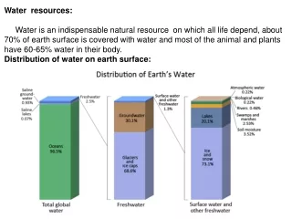
Water cycle is powered by 2 forces: solar energy and gravity • Water is constantly moving but some may be stored for periods of time • Most of the water is in oceans • The replacement period (renewal time) is the time required for the complete replacement of water in various parts of the cycle • Ranges from 9 days to 37,000 years • Oceans • 70% of Earths surface • Major reservoir
Precipitation • Water evaporates, cools and condenses, then falls in liquid or frozen form • Evaporation and Transpiration • 30 inches of average rainfall per year • 2/3 evaporates • Plants lose water through transpiration • Surface Water • 30% of rainfall ends up as surface water • Used for domestic, industrial, recreational purposes
Stream flow averages 4560 billion liters per day • Mississippi River drains 40% of land in US • Groundwater • Water seeping down through the soil is called infiltration • That water moves through the zone of aeration. • Water in this area is called capillary water and is taken up by plants • As water moves down through soil, pollutants stick to soil particles. • So water is cleaner as it moves downward • Zone of saturation – pores in soil are filled with water • Water here is called groundwater
Downward movement is stopped by rock, can create an aquifer • Upper layer of zone of saturation is called the water table • Water table rises and falls depending on precipitation • Humans can use water and lower the water table • If used faster than replaced the water table and aquifer drop deeper • Groundwater may be considered a nonrenewable resource • 97% of liquid freshwater is in aquifers • Ogallala Aquifer – 225,000 sq mi in midwest
10.2 Water Shortages • What Causes Water Shortages? • Rain is not equally distributed throughout the world • Increasing demands also cause shortages • To meet demands water is moved large distances • Agricultural use is also increasing – irrigation • Ogallala Aquifer is used by farmers to irrigate crops • Groundwater overdraft – using water faster than it is replaced
Used in electrical plants to create steam • Water pollution decreases the amount of clean water available • Drought and Climate Change • A drought exists when rainfall for 21 days or more falls substantially below average • Can cause water shortages • Usually accompanied by record heat • Evidence exists that the recent droughts and water shortages are due to climate change
Increasing Water Supplies • Water conservation • Reclamation of sewage water • Development of ground water resources • Desalination of seawater • Rainmaking • Salt and drought resistant crops HW: pg 255 #2-5 Divide into 6 groups and review the assigned section. You will teach the rest of the class about your specific section.
10.3 Flooding • Flood has occurred throughout Earth’s history • Humans alteration of the landscape could be contributing to the problems today • Loss of vegetation increases the amount of water flowing over the surface – surface runoff • Can cause streams and rivers to over flow • Destruction of wetlands can also contribute
Urban development contributes to flooding • Water runoff from parking lots and other paved areas increase the runoff and flooding in watersheds • Controlling and Preventing Floods • We cannot prevent them completely, but when can lessen their impact • Measuring the snowpack helps predict future flooding • Levees are dikes constructed of earth, stone, or mortar at different distances from the riverbank to protect property from floodwater
1936 Flood Control Act – US Army Crops of Engineers responsible for protecting property along Mississippi River and tributaries • Pros: • Have helped to limit damage • 1973 and 1993 landmark floods, levees protected properties • Help maintain depth, important for barges • Allows for agriculture and development along the river • Cons: • Flood damage has increased per capita since levees built • Annual death rate has remained constant • Dam and levee system is not stable • Increases flooding downstream • No wetlands that would have been seasonally flooded • Cut off supply of nutrient rich sediment to land around • $$$ maintenance
3. Dredging – removing sediment from river bottoms • Streambed aggradation – buildup of sediment in channels 4. Dams – used for flood control and electricity production • Reservoirs fill with sediment, evaporation, can collapse, destroy habitat by flooding 5. Stream Channelization • Channelization is the deepening and straightening of steams to control flooding 6. Watershed Protection – Watershed Protection and Flood Prevention Act • Watershed management, reduce erosion, promote wildlife habitats, protect recreational uses 7. Zoning of Floodplains • Federal Flood Disaster Protection Act – encourages development of floodplains into non-structural areas