Download
1 / 3
30 likes | 166 Views
Science Support for Regional and Refuge Bird Conservation Planning. Craig R. Beckman 1 , Shawn E. Weick 1 , Melinda G. Knutson 1 , Timothy J. Fox 1 , Wayne E. Thogmartin 1 , Eileen M. Kirsch 1 , Brian R. Gray 1 , John R. Sauer 2 , Christine A. Ribic 3.

E N D
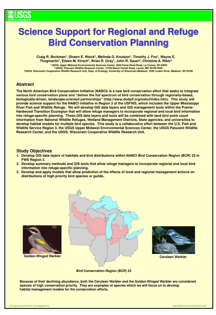
Science Support for Regional and Refuge Bird Conservation Planning Craig R. Beckman1, Shawn E. Weick1, Melinda G. Knutson1, Timothy J. Fox1, Wayne E. Thogmartin1, Eileen M. Kirsch1, Brian R. Gray1, John R. Sauer2, Christine A. Ribic3 1 USGS, Upper Midwest Environmental Sciences Center, 2630 Fanta Reed Road, La Crosse, WI 54603 2 USGS, Patuxent Wildlife Research Center, 12100 Beech Forest Road, Laurel, MD 20708-4039 3USGS, Wisconsin Cooperative Wildlife Research Unit, Dept. of Ecology, University of Wisconsin-Madison, 1630 Linden Drive, Madison, WI 53706 Abstract The North American Bird Conservation Initiative (NABCI) is a new bird conservation effort that seeks to integrate various bird conservation plans and “deliver the full spectrum of bird conservation through regionally-based, biologically-driven, landscape-oriented partnerships” (http://www.dodpif.org/nabci/index.htm). This study will provide science support for the NABCI initiative in Region 3 of the USFWS, which includes the Upper Mississippi River Fish and Wildlife Refuge. We will develop GIS data layers and GIS management tools within the Prairie-Hardwood Transition Ecoregion that will allow refuge managers to incorporate regional and local bird information into refuge-specific planning. These GIS data layers and tools will be combined with land bird point count information from National Wildlife Refuges, Wetland Management Districts, State agencies, and universities to develop habitat models for multiple bird species. This study is a collaborative effort between the U.S. Fish and Wildlife Service Region 3, the USGS Upper Midwest Environmental Sciences Center, the USGS Patuxent Wildlife Research Center, and the USGS, Wisconsin Cooperative Wildlife Research Unit. • Study Objectives • Develop GIS data layers of habitats and bird distributions within NABCI Bird Conservation Region (BCR) 23 in FWS Region 3. • Develop summary methods and GIS tools that allow refuge managers to incorporate regional and local bird information into refuge-specific planning. • 3. Develop and apply models that allow prediction of the effects of local and regional management actions on distributions of high priority bird species or guilds. Golden-Winged Warbler Cerulean Warbler Bird Conservation Region (BCR) 23 Because of their declining abundance, both the Cerulean Warbler and the Golden-Winged Warbler are considered species of high conservation priority. They are examples of species which we will focus on to develop habitat management models for the conservation efforts. U.S. Department of the Interior - U.S. Geological Survey Upper Midwest Environmental Sciences Center
GIS Data Layers We will develop a GIS framework for regional bird conservation planning using a variety of available GIS coverages, including geographic features such as land cover, wetlands, rivers and streams, soils, digital elevation data, and others. We will also develop associated data layers of bird distributions using available data sets, including the Breeding Bird Survey (BBS) and point counts conducted on Federal and state wildlife refuges and from other sources. Federal Land in BCR 23 GIS Coverage Current Land Cover of BCR 23 GIS Coverage Historic Vegetation Cover GIS Coverage Ecoregions of BCR 23 GIS Coverage GIS Tools GIS data layers, combined with specific species information, will be used to develop GIS-based management tools. These tools are suitable for use by regional FWS staff, refuge managers, and scientists who want to be able to predict a species’ probability of occurrence and other community attributes within a refuge or other wildlife area. Such tools will be used to test more advanced habitat models, plan future field research, propose new land acquisitions, and guide site-specific management and habitat restoration efforts. • New spatial data layers • Text reports • Tables • Charts • Maps Multiple Spatial Data Species/Habitat Matrix U.S. Department of the Interior - U.S. Geological Survey Upper Midwest Environmental Sciences Center
Model Development As a first step in the process, we worked with wildlife refuges and the USGS Patuxent Wildlife Research Center to integrate point count data collected from USFWS Refuges into an MS Access database. The database mirrors the national Bird Point Count Database being developed at Patuxent. The database records the data and metadata needed for future use of the point count databases in modeling efforts. Incorporating data from multiple sources into a unified Access database without re-entering the data proved to be a major challenge. Problems included ambiguous mapping of point locations, bird names that did not match the master list, loss of metadata necessary for full understanding of the data, and differences in data collection methods and recording. Species code and number Radius and time of each count Point name and description Actual species counts UTM coordinates of each point Portion of cells from Access database Point counts must have UTM coordinates for each individual point to be entered into the database. The specific coordinates will be used to place each point in its proper position on GIS land cover maps. Once completed, the Prairie-Hardwood (BCR 23) database will be useful for conservation planning at the refuge and regional scale, and the data will be available for use in modeling work. The database will also provide a template for future recording of point count data. To date, point count data have been received from Minnesota Valley NWR, Litchfield WMD, Sherburne NWR, Crane Meadows NWR, Hamden Slough NWR, Horicon NWR, Fox River NWR, Leopold WMD, Necedah NWR, Upper Miss NWR, Rydell NWR, Fergus Falls WMD, and St.Croix WMD as well as point counts from state owned land in Southeast Minnesota and Northeast Iowa. Map of Point Count Locations Simple GIS habitat models will be built to estimate the probability of occurrence of selected bird species, based on the literature. Then, we will build more advanced statistical models of habitat associations using Breeding Bird Survey (BBS) and point count data. We will also investigate the usefulness of habitat models for predicting community indices such as species richness. Modeling Process Acknowledgments: Funding provided by USGS, Upper Midwest Environmental Science Center, and USGS, Strategic Science Support. Thanks to Tom Will and Steve Lewis (USFWS, Region 3), Nick Danz (University of Minnesota), Bill Norris (New Mexico State University), and BCR 23 Refuge Managers and staff. U.S. Department of the Interior - U.S. Geological Survey Upper Midwest Environmental Sciences Center