Download
1 / 42
420 likes | 788 Views
Trails, Watersheds and Wetlands. An introduction to the science of Hydrology and its relation to hiking trails . Presented by: William Richardson. A bit about me Why do we care Hydrology The Hydrologic Cycle Watershed Delineation Wetlands. Vernal Pools Wetland Protection

E N D
Trails, Watersheds and Wetlands An introduction to the science of Hydrology and its relation to hiking trails . Presented by: William Richardson
A bit about me Why do we care Hydrology The Hydrologic Cycle Watershed Delineation Wetlands Vernal Pools Wetland Protection Trail definitions Environmental Impacts on trails Summary Field Trip Today’s Outline
Your Presenter • Environmental Science education at Rutgers University • Six years with the NYC-DEP Bureau of Water Supply • 5 in Pathogen Surveillance • 1 in Watershed Hydrology
Why Interested in Watersheds and Wetlands? Traditional Benefits of proper mangement Aesthetics Improve water quality Natural buffer zones Flood water storage Aquifer Recharge
Other Reasons of Interest in Watersheds and Wetlands? Regulations • Clean Water Act • The SDWA amendments of 1986 • The SWTR of 1989 • Microbiologic concerns - Requires filtering of surface water supplies
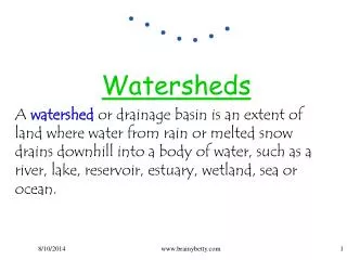
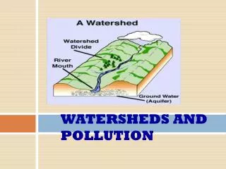
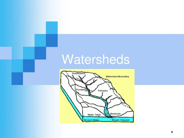
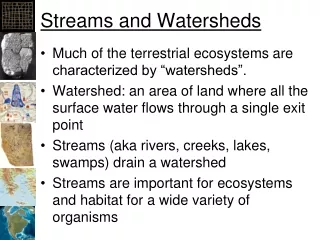
What is a Watershed • Watershed- The entire region drained by a waterway (or into a lake or reservoir. More specifically, a watershed is an area of land above a given point on a stream that contributes water to the streamflow at that point. -USFS • Watershed -Land area from which water drains toward a common watercourse in a natural basin. -NWS
What is a Wetland • Wetlands- Areas that are permanently wet or are intermittently covered with water. -USFS • Wetland- An area that is regularly wet or flooded and has a water table that stands at or above the land surface for at least part of the year. -NWS
What is a Trail • “A track or blazed path, as through wilderness. Webster’s II
What is a Watershed • Watershed- The entire region drained by a waterway (or into a lake or reservoir. More specifically, a watershed is an area of land above a given point on a stream that contributes water to the streamflow at that point. -USFS • Watershed -Land area from which water drains toward a common watercourse in a natural basin. -NWS
Hydrology- Defined • Hydrology treats the waters of the earth, their occurrence, circulation and distribution, their chemical and physical properties, and their reaction with their environment, including their relation to living things. The domain of hydrology embraces the full life history of water on the earth. - Federal Council for Science and Technology, 1962
Hydrology 101 • The Hydrologic Cycle • Precipitation (rain) • Infiltration (soaking in) • Percolation (soaking really far in) • Runoff (streamflow) • Evaporation (evapo-transpiration)
What’s the Difference • Rivers, Streams, Creeks, Kills, Washes, Brooks, Runs, • Technically nothin • In general Rivers are large streams are small • Linguistic/ Regional
Source: Purdue University Agricultural & Biological Engineering Department and The Environmental Protection Agency (1996) Ground water basics: the hydrologic cycle, in: Ground Water Primer.
Watershed Delineation • Defining the Topographic Divide • Divide runs along ridges and contours • Divide is always drawn perpendicular to contours • In theory a droplet of water falling on the line will split and go both ways • Most important- Water flows downhill
Why Delineate?? • Land use planning • Maintain even uses across a region • Identify sensitive areas • Streams are often at the center of the watershed and are generally the most sensitive areas • Water Resource planning • Trail planning: Only so many trails can exist in an given area
What is a Wetland • Wetlands- Areas that are permanently wet or are intermittently covered with water. -USFS • Wetland- An area that is regularly wet or flooded and has a water table that stands at or above the land surface for at least part of the year. -NWS
Types of Wetlands • Classification: systems, and classes • Systems: based on associated waterbodies • Riverine = rivers and streams • Lacustrine = lakes, reservoirs, large ponds • Palustrinre = swamps, marshes, small ponds, bogs, • Classes: based on vegetation types • Emergent • Scrub Shrub • Open-water
Vernal Pools – very frail wetlands • Physical description of a vernal pool A vernal pool is a contained basin depression lacking a permanent above ground outlet. In the Northeast, it fills with water with the rising water table of fall and winter or with the meltwater and runoff of winter and spring snow and rain.
Vernal Pools – very frail wetlands • Biological description of a vernal pool A vernal pool, because of its periodic drying, does not support breeding populations of fish. Many organisms have evolved to use a temporary wetland which will dry but where they are not eaten by fish. These organisms are the "obligate" vernal pool species, so called because they must use a vernal pool for various parts of their life cycle. Examples: the fairy shrimp, the mole salamanders and the wood frog.
Wetland Protection Strategies I. Wetland mapping and Inventory (NWI) II. Regulatory Programs III. Non- regulatory programs
National Wetlands Inventory(NYC Watersheds) • Compiled by USF&WS via 1:58000 CIR aerial photography from 1982-87 • 27,968 acres of Wetlands inventoried • 36,008 acres Deepwater habitats inventoried
NWI ResultsDelaware Watershed • 8,287 acres of wetlands • 1.3% of watershed area • Mostly shorelines and shallow ponds (37% of area)
NWI ResultsCatskill Watershed • 3,872 acres of wetlands • 1% of watershed area. • Mostly forested wetlands (32%)
NWI ResultsCroton Watershed • 15,809 acres of wetlands • 6.4% of watershed area • Forested wetlands dominate (71% of area)
Regulatory Programs Empowering Legislation SEQRA – State Environmental Quality Review Act. Environmental Conservation Law Articles 24 & 25 Clean Water Act • Allows Interested agencies to address potential impacts on wetlands for development projects. (This may include trails) • Enables review of wetland permit applications
Regulatory Programs Wetland Map Revision • Environmental Conservation Law Article 24 • To receive regulatory protection NY state wetlands must be identified on official regulatory maps and be greater than 12.4 acres or be determined to be of “unusual local importance”. • The NWI has identified additional wetlands or expanded areas of previously mapped wetlands that may qualify for designation pursuant to ECL Article 24
Non Regulatory ProgramsWetland Science and Research Wetland Trend Analysis • Examines extent of wetland gains or losses in the Croton watershed Wetland Functional Assessment • Examines storage of sediment, flood waters and nutrients estimate exports Wetland Hydrology
What is a Trail • “A track or blazed path, as through wilderness. Webster’s II
Why have trails?? • Provide recreational opportunities along aesthetically pleasing trail routes • Protect resources by concentrating traffic on a hardened tread • Facilitate recreational use via their transportation network
Some Trail Definitions • Trail Impact: General term encompassing all physical, ecological, and aesthetic effects of building and using trails. Including the environmental nuisance and social impacts of bad people such as vandalism and littering. • Trail Degradation: General Term often used interchangeably with trail impact, wear, erosion, and deterioration.
Some (more) Definitions • Trail deterioration: Often refers to trail proliferation (as if it were a bad thing) and vegetation assesments. • Trail erosion: Refers to the processes and consequences of erosion. • Trail degradation studies: Focus on the effects of trail use on the trail tread. And importantly how to keep the trail from degrading
General findings of trail research • Critical problems: soil compaction, trail widening, trail incision. Result is erosion • Majority of Changes occur with the initial construction • Environmental factors are an important determinant for wear. (think of any single trail that has both good and bad sections)
Environmental factors affecting trail wear • Climate • Geology (soil type) • Vegetation • Topography (slope) • Orientation (trail angle) • Water proximity • Initial use/ design
Climate • A regions climate indirectly impacts trail wear through several factors. • Vegetation • Freeze thaw cycling. • Precipitation an exception due to the direct effects of raindrop impact and runoff along trails.
Geology and Soils • Soils • Fine textures wear easier, have greater incision • Regional scope. Different rocks wear differently • Catskills Sandstones • Lower Hudson valley Metamorphic rocks • Limestone ridges and valleys (Western NJ)
Trail Slope and Angle • Topography (steepness) • Most intensely studied aspect • Steeper slopes have been demonstrated to wear more quickly • Higher velocity of runoff • Angle • Often overlooked • By following contours can reduce wear
Water • Ultimate vehicle for transporting material down slope (the Catskill Delta) • Proximity to springs and seeps • Generally causes trail widening • Large rainfall events (the hurricane floyds) • One single storm may do more damage than years of previous weathering
Initial Use/Design • Many trails started out as non-recreational uses such as logging roads, wagon trails, railroad grades etc. • Shortest or Path of least resistance. Follow the streams- No!
Summary • Trails, streams and wetlands have co- existed for quite a long time. Their aesthetic beauty will continue to draw us for generations. With planning and commitment we can maintain a healthy ecosystem to treasure for a lifetime.
References • Leung, Yu-fai and Marion Jeffery L. Trail degradation as influenced by environmental factors: a state of the knowledge review. Journal of Soil and Water Conservation 51:2, 130-137 • Tiner, Ralph W. Atlas of Natl Wetlands Inventory Maps for the Watersheds of the New York City Water Supply System • Vernal Pool Association: http://earth.simmons.edu/vernal/pool/vpinfo_1.htm