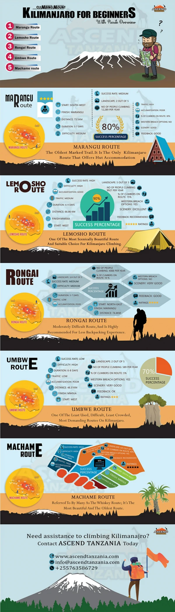
Download
1 / 27
270 likes | 447 Views
A Wilderness permit is required for each person on this trip and they can be purchased at the forest service ranger station in Lone pine.If you would like to have a fire on this trip you will also need a separate California fire permit that can be obtained from any U.S. forest service ranger stati

E N D
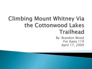
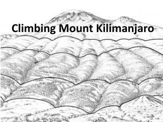
1. Climbing Mount Whitney Via the Cottonwood Lakes Trailhead By: Brandon Wood
For Kpea 119
April 17, 2009
2. A Wilderness permit is required for each person on this trip and they can be purchased at the forest service ranger station in Lone pine.
If you would like to have a fire on this trip you will also need a separate California fire permit that can be obtained from any U.S. forest service ranger station. However fires are only allowed below 10,000 feet and you will only be below 10,000 two nights during this trip.
You must reserve your permit by phone or internet from the Inyo-kern forest service ranger station 6 MONTHS IN ADVANCE.
When submitting your request you must give them your itinerary, which includes where you will hike and camp each day of the hike and what day you will be there.
A fee of $15.00 per person is required for each permit.
A car shuttle is necessary for this hike because you will be ending at a different place then you start. A car needs to be left at Whitney Portal which is the end of the hike and then one car has to go back to the Cottonwood Lakes trail head so you can start the hike.
Planning for the Hike
3. Taking other hikes that challenge your physical abilities is very important for this hike. This hike is very difficult and 55 miles long so making sure your boots and pack are comfortable prior to the trip is extremely important.
Pack light and make sure all gear fits in the pack and make sure the week�s worth of food fits into a bear canister (Mandatory).
Packs should weigh as close to 40 pounds as possible for this hike. I have done this hike twice and my pack has weighed 42 pounds the first time and 45 the second so it can be done.
The best time to go on this hike is either July or August due to snow. But remember that permits need to be reserved 6 months to the day! So plan ahead and prepare thoroughly.
Getting a topo map of the area is a wise idea. Some names of possible maps: USGS Olancha, Kern Peak, Mt. Whitney & Lone Pine, CA or Tom Harrison maps- Mt. Whiney High country trail. Planning for the Hike Cont.
4. Things to Bring on Trip The ten essentials are a must!
1) Map
2) Compass
3) Sun Screen/sunglasses/Chap stick
4) Food & Water
5) Extra Clothes
6) Flashlight
7) First aid kit
8) Fire starter
9) Matches
10) Knife
5. Backpack
Cup/mess kit/spork
Ground Cloth
Hiking boots (wear)
Beanie/gloves
Jacket
50 ft of nylon rope
Bug repellent
Sleeping bag
Sleeping pad
Trash bags
Water Shoes Rain gear
Wool socks
Survival kit
Water filter
Whistle
Toilet paper & shovel
Tooth brush & tooth paste
Stove & pot set
Tent
2 one quart water bottles Things to Bring on Trip Cont.
6. Possible Items for Menu Breakfasts: Cereal bars, Nutri-grain bars, Pop tarts, Oatmeal, Cliff bars, Mountain house breakfasts, etc.
Lunches: Beef jerkey, trail mix, peanut butter with tortillas, cliff bars, dried fruits, Cheese wiz with crackers, summer sausage, tuna and crackers, etc.
Dinners: Mountain house dinners, bear creek soups, MRE�s, etc.
7. After picking up the wilderness permit from the ranger station the day before, day one of hiking begins.
Cottonwood lakes trail head is at 9,660 ft. in elevation.
Long lake which is at the base of New Army pass is at 11,140 ft. in elevation and 6 miles from the trailhead. And a gain in elevation 1,480 ft.
This day is a pretty easy day and there is water that you can filter all along the way.
Long lake is a very nice place to camp! Close to water and in the trees. Day One of the Hike
8. Picture of Long Lake
9. Hike from Long Lake to Rock Creek ranger station.
This is a much more difficult day because New Army Pass must be climbed.
This day is ten miles long and is pretty strenuous due to a 1,170 ft. gain in elevation.
New army pass is at an elevation of 12,310 ft.
After climbing three miles to the summit the trail descends through a couple meadows and on to the Rock Creek ranger station were you stay the night next to a creek.
Barely making it at 9,990 ft. this is the only night on the trip where you are below 10,000 ft. so this is the only night you can have a fire. Day Two of the Hike
10. Pictures of rock creek area
11. Pictures of Rock Creek area cont.
12. Picture Near Rock Creek campground
13. Day three takes you from Rock Creek to Guitar lake.
It starts out with a steep climb over Guoyt pass, but for the most part it is either flat, down hill or very mild climbs.
This day is also ten miles long with 1,469 ft. in elevation gain.
After the top of Guoyt pass there is no water around until you get to Crabtree meadow. So making sure you have plenty of water at every creek you pass on the way is a good idea for this day. Day Three of Whitney Hike
14. Picture of Creek Crossing
15. Picture of Creek Crossing Cont.
16. Pictures of Crabtree meadow
17. Guitar Lake which is at11,459 ft. is called guitar lake because it is actually shaped like a guitar.
The water in this lake is freezing cold so you cant swim for very long at a time, but it is nice and refreshing.
There is a little stream that runs into the lake that has small fish in it that you can try to catch if you bring a fishing license.
This day is a great day to rest and recuperate because the next day is the day you summit Whitney.
Laying out in the sun or in your tent and playing cards with your buddies is perfect for relaxing and resting for the hard day to come. Day Four is a day for resting at Guitar Lake
18. Pictures of Guitar Lake
19. Picture of Whitney from Guitar Lake
20. Due to the fact that the climb from Guitar Lake to trail crest pass is 3 miles long plus a gain of 2,021 ft. in elevation it is necessary to get up very early to beat the crowd to the top.
Many people climb Mount Whitney every day so getting up around five and leaving early is smart.
Once at trail crest everyone usually drops their packs and puts on smaller day packs for the final 2 mile trek to the summit, which is at 14,497 ft. in elevation.
These two miles are fairly easy and many pictures can be taken of the amazing views of the valley below.
Day Five of the Hike
21. Once at the top there is a lightning shack that can be used as a last resort in case of a severe storm. However it is not recommended that a person stays in the shack, because it wont protect you very much, the best thing to do in a storm is to get to a lower elevation as fast as you can.
There is a book to sign your name in to let everyone know you made it to the top.
Some cell phones even get enough service to call home from the highest point in the Continuous United States.
The view from the top is one of the best views in the world! Day Five of the Hike Cont.
22. Once done at the top you hike the two miles back to trail crest and pick up your packs and head to Out Post camp.
There are 99 switchbacks down from trail crest to trail camp and they seem to take forever!
Once at trail camp there is a lake and campsites, but often times it is too crowded to camp by the time you get there so continuing on to outpost camp is a good idea.
This is the longest day yet with a grand total eighteen miles and a gain of 3,038 ft. in elevation from guitar Lake to outpost camp. Day Five of the Hike Cont.
23. Pictures from day Five
24. Pictures of the top of Whitney
25. Day six is the easiest day of the entire hike because it is all down hill to Whitney portal.
From outpost camp to the portal is only three and a half miles.
At the portal there are showers for a very high price. So most people wait until they get home to shower.
But they have the best tasting burgers and fries in the world. After six days of hiking this burger tastes so good and is well worth the cost.
There is a gift shop to buy your �I climbed Mount Whitney� shirts, and any other Whitney memorabilia you want. Day Six of the Hike (LAST DAY)
26. After eating your burger and buying your souvenirs it is time to drive back over to the Cottonwood lakes trail head where you began your hike to pick up the other car.
Once you get the other car it is time to head down the mountain to lone pine and back home.
For every 1,000 ft. in elevation that you gain you add a mile, so for this trip we take 7,156 ft. (7 miles) and add that to 47.5 miles and we get a grand total of 55 miles for this hike.
THE END
Day six cont.
27. Inyo national forest website http://www.fs.fed.us/r5/inyo/about/
Schneider, Russ, and Bill Schneider. Backpacking Tips : Trail Tested Wisdom from Falconguide Authors. 2nd ed. Helena: Falcon, 2005. 85-88.
Seamands, Mark.�Mt. Whitney�West Side.�Where To Go Backpacking Guide.�1st ed.�2009.Print.
"Wilderness permits.� 15 Apr 2009 <http://www.cityconcierge.com/mammoth-lakes/activities/wilderness-permit.asp>.
Wood, Matt. Personal interview.10 Apr 2009.Interview
Works Cited