Download
1 / 1
10 likes | 95 Views
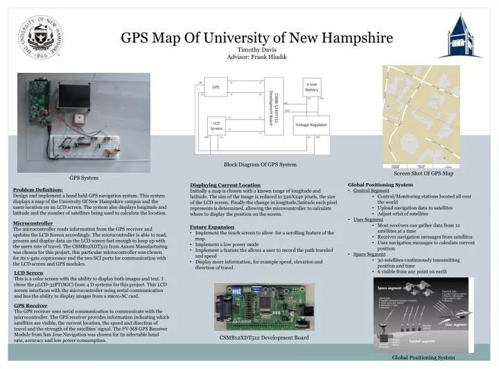
GPS Map Of University of New Hampshire Timothy Davis Advisor: Frank Hludik. Block Diagram Of GPS System. Screen Shot Of GPS Map. GPS System. Global Positioning System Control Segment Control/Monitoring stations located all over the world Upload navigation data to satellites

E N D
GPS Map Of University of New Hampshire Timothy Davis Advisor: Frank Hludik Block Diagram Of GPS System Screen Shot Of GPS Map GPS System • Global Positioning System • Control Segment • Control/Monitoring stations located all over the world • Upload navigation data to satellites • Adjust orbit of satellites • User Segment • Most receivers can gather data from 12 satellites at a time • Receives navigation messages from satellites • Uses navigation messages to calculate current position • Space Segment • 30 satellites continuously transmitting position and time • 6 visible from any point on earth Displaying Current Location Initially a map is chosen with a known range of longitude and latitude. The size of the image is reduced to 320X240 pixels, the size of the LCD screen. Finally the change in longitude/latitude each pixel represents is determined, allowing the microcontroller to calculate where to display the position on the screen. Problem Definition: Design and implement a hand held GPS navigation system. This system displays a map of the University Of New Hampshire campus and the users location on an LCD screen. The system also displays longitude and latitude and the number of satellites being used to calculate the location. Microcontroller The microcontroller reads information from the GPS receiver and updates the LCD Screen accordingly. The microcontroller is able to read, process and display data on the LCD screen fast enough to keep up with the users rate of travel. The CSMB12XDT512 from Axiom Manufacturing was chosen for this project, this particular microcontroller was chosen for its x-gate coprocessor and the two SCI ports for communication with the LCD screen and GPS modules. • Future Expansion • Implement the touch screen to allow for a scrolling feature of the map. • Implement a low power mode • Implement a feature the allows a user to record the path traveled and speed • Display more information, for example speed, elevation and direction of travel. LCD Screen This is a color screen with the ability to display both images and text. I chose the µLCD-32PT(SGC) from 4 D systems for this project. This LCD screen interfaces with the microcontroller using serial communication and has the ability to display images from a micro-SC card. GPS Receiver The GPS receiver uses serial communication to communicate with the microcontroller. The GPS receiver provides information indicating which satellites are visible, the current location, the speed and direction of travel and the strength of the satellites’ signal. The FV-M8 GPS Receiver Module from San Jose Navigation was chosen for its selectable baud rate, accuracy and low power consumption. CSMB12XDT512 Development Board Global Positioning System