Download
1 / 15
200 likes | 403 Views
Choose to view chapter section with a click on the section heading. Surface Currents Deep Currents Studying Ocean Currents. Chapter Topic Menu.

E N D
Choose to view chapter section with a click on the section heading. • Surface Currents • Deep Currents • Studying Ocean Currents Chapter Topic Menu
Understanding what causes currents and where they flow is fundamental to all marine sciences. It helps explain how heat, sediments, nutrients, and organisms move within the seas. Causes of Currents • Three major factors drive ocean currents. • 1. Wind. • If the wind blows long enough in one direction,it will cause a water current to develop. • The current continues to flow until internal friction,or friction with the sea floor, dissipates its energy. • 2. Changes in sea level. • Sea level is the average level of the sea’s surface at its meanheight between high and low tide. • The ocean’s surface is never flat, ocean circulation cause slopes to develop. The steeper the “mound” of water, the larger and faster the current. The force that drives this current is the pressure gradient force. • 3. Variations in water density. • Differences in water density also cause horizontal differences in water pressure. When the density of seawater in one area is greater than another, the horizontal pressure gradient between the two areas initiates a current that flows below the surface. Surface Currents Chapter 9 Pages 9-3 & 9-4
Gyres • The combination of westerlies, trade winds, and the Coriolis effect results in a circular flow in each ocean basin. This flow is called a gyre. • There are five major gyres – one in each major ocean basin: • 1. North Atlantic Gyre • 2. South Atlantic Gyre • 3. North Pacific Gyre • 4. South Pacific Gyre • 5. Indian Ocean Gyre • The flow of currents in all parts of theocean is a balance of various factors,including the pressure gradient force,friction, and the Coriolis effect. Surface Currents Chapter 9 Pages 9-5 & 9-6
Ekman Transport • The Ekman transport is an interesting phenomenondiscovered in the 1890s by Fridtjof Nansen. • The wind and the Coriolis effect influences waterwell below the surface because water tends to flowin what can be imagined as layers. • Due to friction, the upper water currents push the deep water below it. This deep layer pushes the next layer below it. The process continues in layers downward. Each water layer flows to the right of the layer above causing a spiral motion. • This spiraling effect of water layers pushing slightly to the right from the one above (to the left in the Southern Hemisphere) is called the Ekman spiral. • There is a net motion imparted to the water column down to friction depth. This motion is called the Ekman transport. • The net effect, averaging of all the speeds and directions of the Ekman spiral, is to move water 90° to the right of the wind in the Northern Hemisphere, or to the left in the Southern Hemisphere. Surface Currents Chapter 9 Pages 9-6 to 9-8
Western and Eastern Boundary Currents • Satellite images show that the oceans are really “hilly,” not calm or flat. • These images show that water piles up where currents meet. Where currents diverge, “valleys” form. • There is a dynamic balance between the clockwise deflection of the Coriolis effect (attempting to move water to the right) and the pressure gradient created by gravity (attempting to move the water to the left). • The balance keeps the gyreflowing around the outside ofthe ocean basin. • Geostrophic currents arecreated by the Earth’s rotation. • This current results from thebalance between the pressuregradient force and theCoriolis effect. Surface Currents Chapter 9 Pages 9-8 to 9-10
Western and Eastern Boundary Currents (continued) • Western boundary currents are found onthe east coasts of the continents and are stronger and faster than eastern boundary currents due to western intensification. Western boundary currents flow through smaller areas than eastern boundary currents. • Trade winds blow along the equator pushingwater westward, causing it to “pile up” on the western edge of ocean basins before it turns to the poles. The Earth’s rotation tends to shift the higher surface level in the center of the gyre westward. The higher surface level is now west of center and forces the current to “squeeze” through a narrower area. • Total water volume balances out.Western boundary currents handle thesame volume, but through smaller areas,so water must move more rapidly. Surface Currents Chapter 9 Pages 9-10 to 9-16
Countercurrents • Countercurrents and undercurrents are water flows that differ from the major ocean currents. • Countercurrents are associated with equatorial currents – it runs opposite of its adjacent current. • It is hypothesized they develop in equatorial regions because of the doldrums. Without wind pushing water westward, water driven in from the east enters the basin more quickly than it exits. This causes a countercurrent to develop. • Undercurrents flow beneath theadjacent current and are foundbeneath most major currents. • They can significantlyaffect land masses and land temperatures. Surface Currents Chapter 9 Pages 9-16 & 9-17
Upwelling and Downwelling • Upwelling is an upward vertical current that brings deep water to the surface. Downwelling is a downward vertical current that pushes surface water to the bottom. • Coastal upwellings occur when the wind blows offshore or parallel to shore. In the Northern Hemisphere this wind blowing southward will cause an upwelling only on a west coast. • The same wind on the east coast in the Northern Hemisphere sends surface water toward shore causing a downwelling. • These currents have strongbiological effects: • Upwelling tends to bring deepwater nutrients up into shallow water. • Upwellings also relate to significant weather patterns. • Downwellings are important in carrying and cycling nutrients to the deep ocean ecosystems and sediments. Surface Currents Chapter 9 Pages 9-17 to 9-20
Heat Transport and Climate • Currents play a critical role by transporting heat from warm areas to cool areas and affects climate by moderating temperatures. Without currents moving heat, the world’s climates would be more extreme. El Niño Southern Oscillation (ENSO) • El Niño tremendously affects worldweather patterns. • This brings low pressure and highrainfall in the Western Pacific. • The opposite happens in the EasternPacific with high pressure andless rainfall. Surface Currents Chapter 9 Pages 9-20 to 9-22
For reasons still not clear, every 3 to 8 years a rearrangement of the high- and low-pressure systems occur. High pressure builds in the Western Pacific and low pressure in the Eastern Pacific. Trade winds weaken or reverse and blow eastward – the southern oscillation. This causes warm water of the west to migrate east to the coast of South America. The loss of upwelling deprives the water of nutrients. A normally productive region declines with the collapse of local fisheries and marine ecosystems. Over the eastern Pacific, humid air rises causing precipitation in normally arid regions. Flooding, tornados, drought and other weather events can lead to loss of life and property damage. El Niño (continued) Surface Currents Chapter 9 Pages 9-22 to 9-24
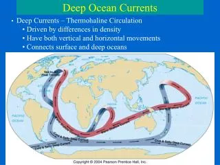
Thermohaline Circulation and Water Masses • Thermohaline circulation is water motion caused by differing water densities. • In the deep-ocean layers, water density variation, not wind, is the primary causeof current. • Circulation drives most of the vertical motion of seawater and the ocean’s overall circulation. • Thermohaline circulation works because waterdensity increases due to cooling, increasedsalinity or both. • When water becomes dense, it sinks, causing a downward flow. • This means water in some other place must rise to replace it, causing an upward flow. • Density differences drive the slow circulation of deep water. Deep Currents Chapter 9 Pages 9-26 & 9-27 Five distinct water masses result from density stratification.
How Deep Water Forms • The intermediate, deep, and bottom watermasses form primarily, but not entirely, athigh latitudes (around 70° North and South). • The densest ocean waters, Antarctic Bottom Waters form in the Antarctic in winter, sink to the bottom and spread along the ocean floor to about 40° north latitude. • In the Arctic the North Atlantic Deep Waters form, but often get trapped there by the topography of the ocean basin. • In the Northern Hemisphere along the east coast of the Siberian Kamchatka Peninsula the Pacific Deep Waters form. Not as dense as bottom water they make up the deep layers. • Mediterranean Deep Waters form due to evaporation rather than cooling, with a salinity of 38‰. Flowing out of the Mediterranean they form the intermediate water layer resting above the bottom layer and deep layer. Deep Currents Chapter 9 Pages 9-28 to 9-30
The enormous water quantities sinking at the poles and in the Mediterranean create the thermohaline circulation pattern. Dense water descends into low areas and bottom water upwell to compensate. The rising warm water enters wind-driven currents and is carried to the poles. There it cools, becomes more dense, and sinks again, repeating the process. The Ocean Conveyor Belt The interconnected flow of currents that redistribute heat is called the ocean conveyor belt or the Earth’s “air conditioner.” The ocean conveyor belt is important because it moderates the world’s climate. This marriage of surface and deep water circulation carries heat away from the tropics and, in turn, keeps the tropics from getting too hot. Some scientists hypothesize that some Ice Ages may have resulted from a disruption of the conveyor belt. Deep-Water Flow Patterns Deep Currents Chapter 9 Pages 9-30 to 9-33
Two Distinct Approaches • There are two main approaches to study currents: • 1. Lagrangian method, also called the float method. • Studying the current by tracking a drifting object. This involves floating something in the current that records the information as it drifts. • 2. Eulerian method, also called the flow method. • Studying the current by staying in one place and measuring changes to the velocity of the water as it flows past. This method uses fixed instruments that meter/sample the current as it passes. Instrumentation and Methods • There are five examples of instruments or methods that scientists apply for studying currents. • For Lagrangian study methods researchers use: • 1. A drogue. The advantage over a simple surfacefloat is that the “holey sock” ensures that the current andnot the wind determine where it drifts. Studying Ocean Currents Chapter 9 Page 9-34
Instrumentation and Methods (continued) • 2. The Argo float drifts at depth before periodically rising to the surface to transmit to a satellite a temperature and salinity profile of the water it rose through. • For Eulerian study methods researchers use: • 3. Various types of flow meters. These devicesuse impellors and vanes to measure and recordcurrent speed and direction. The information gatheredis either transmitted immediately or stored forretrieval later. • 4. A more sophisticated device is the Doppler AcousticCurrent Meter. This instrument determines currentdirection and speed. • 5. Oceanographers can now use satellites to help them.Although they are primarily used for studying the surface,these instruments use laser and photography to study currents. Studying Ocean Currents Chapter 9 Pages 9-35 to 38