Download
1 / 68
680 likes | 821 Views
Example 1. A Minimal HEC-HMS Model. Purpose. Illustrate the steps to create a functioning precipitation-runoff model in HEC-HMS. The example is “minimal” in the sense that only a small set of HEC-HMS capabilities are employed

E N D
Example 1 A Minimal HEC-HMS Model
Purpose • Illustrate the steps to create a functioning precipitation-runoff model in HEC-HMS. • The example is “minimal” in the sense that only a small set of HEC-HMS capabilities are employed • Realistic parameter values are employed from public-domain references, but the example is fabricated for pedagogical simplicity.
Learning Objectives • Familiarize students with the HEC-HMS Graphical User Interface. • Reinforce the concepts of “Projects” as a data-storage paradigm. • Simulate the rainfall-runoff response of a single sub-basin Texas watershed using: • Initial loss and constant rate loss model • SCS Unit Hydrograph transformation model • User-specified hyetograph.
Problem Statement • Simulate the response of the Ash Creek watershed at Highland Road for a 5-year, 3-hour storm, under current development conditions. • Treat the entire watershed as a single sub-basin.
Problem Statement • Watershed Outlet • Highland Road and Ash Creek, Dallas, TX. • Area is residential subdivisions, light industrial parks, and some open parkland. • White Rock Lake is water body to the North-West
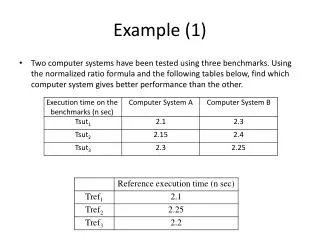
Precipitation Estimation • Precipitation • Estimate 5-year, 3-hour storm depth using the DDF Atlas
Precipitation Estimation • Precipitation • Approximate the storm temporal distribution using dimensionless hyetograph.
Loss Model Estimation • Runoff Generation (Loss) • Estimate the initial loss and constant rate loss using TxDOT 0-4193-7
Transformation Model Estimation • Unit Hydrograph Timing Parameters • Example will use the SCS DUH, but will parameterize assuming GUHAS regression is appropriate.
Physical Properties • Watershed Properties • AREA=6.92 mi2 • MCL=5.416 mi • MCS=0.005595 • CN=86 • R=0
Building The Model – Data Preparation • HEC-HMS will require us to construct, external to HMS the following: • A Hyetograph (rainfall) • Loss model parameters • Transform model parameters • In this example will use Excel to build some input data required by the program.
Rainfall Depth • Use the DDF atlas to find the 5-year, 3-hour storm depth for Dallas Texas. • About 2.8 in.
Generate a Hyetograph • Dimensionless Hyetograph is parameterized to generate an input hyetograph that is 3 hours long and produces the 5-year depth. • We won’t actually use the graph, instead use the tabular values in the report. • For this example, will use the median (50th percentile) curve 0 – 2.8 inches 0 – 3 hours
We won’t actually use the graph, instead use the tabular values in the report. • This column scales TIME • This column scales DEPTH
Dimensional Hydrograph • Use interpolation to generate uniformly spaced cumulative depths. • Can use Excel and high-order polynomial. • HEC-HMS has built-in linear interpolation tools. • This example will interpolate external to HEC-HMS, then import the results.
Input Hyetograph • We will use this column in HEC-HMS and specify a 5-minute rainfall time-series.
Data Preparation • HEC-HMS will require us to construct, external to HMS the following: • A Hyetograph (rainfall) • Loss model parameters • Transform model parameters • In this example will use Excel to build some input data required by the program.
Loss Model Parameters • IaCl model in TxDOT 0-4193-7
Loss Model Parameters • IaCl model in TxDOT 0-4193-7
Loss Model Parameters • IaCl model in TxDOT 0-4193-7
Loss Model Parameters • IaCl model in TxDOT 0-4193-7
Data Preparation • HEC-HMS will require us to construct, external to HMS the following: • A Hyetograph (rainfall) • Loss model parameters • Transform model parameters • In this example will use Excel to build some input data required by the program.
Unit Hydrograph Model • SCS Dimensionless Unit Hydrograph • Related to a gamma distribution with shape K=3.77 • HEC-HMS requires a time constant, Tp • For this example, will assume 0-4193-4 method is sufficient
Unit Hydrograph Model • Estimate Tp
Unit Hydrograph Model • Estimate K
Unit Hydrograph Model • Estimate K
Unit Hydrograph Model • SCS Dimensionless Unit Hydrograph • Related to a gamma distribution with shape K=3.77 • For this example • Assume that K=3.77 is close enough in shape to K=3.2 to use without modification. • A later example will illustrate how to employ a user-specified hydrograph.
Data Preparation • HEC-HMS will require us to construct, external to HMS the following: • A Hyetograph (rainfall) • Loss model parameters • Transform model parameters • Now ready to build the HEC-HMS model.
HEC-HMS • Start the program • Create a project • Project is a directory where all data are stored for a particular model. • Can share files between projects, but an advanced technique.
HEC-HMS • Start the program Choose “File” and “New” to create a new project
Create Project Name the Project Description (optional) Select Default Units (Metric or U.S. Customary)
Create Project Name of the Project Note that project was created. This area is where notes, warnings, and error messages are presented to analyst.
Create Basin Model Choose “components” and will begin our modeling
Create Basin Model Choose “Basin Model Manager”
Create Basin Model Choose “New” Name the Basin Description
Create Basin Model 2) “Sub Basin Creation Tool” Select, then put a sub-basin into the hydrologic elements area 1) Select the Basin Name in the Component Manager Window Basin Hydrologic Elements (Starts Empty – we will populate)
Create Basin Model Sub-basin name Description (optional)
Basin Model Data Input 1) Select “cursor” tool 2) Select the sub-basin 3) Input hydrological and physical parameters When you change from defaults, program will Ask you “are you sure?” For the example, answer yes and proceed. 4) When done, select the “Loss” tab.
Basin Model Data Input 1) Input hydrological and physical parameters Use values from 0-4193-7 Use 0% IC; 0-4193-7 accounted for IC 2) When complete, select “Transform” tab.
Basin Model Data Input 1) Input hydrological and physical parameters Use values from 0-4193-3 Use the standard SCS-DUH. 2) When complete, select “Components” menu item
Create Rainfall Input • Choose “Time-series” Data Manager • Will supply the hyetograph input as a time-series. • a) Create a raingage • b) Assign a time-series to the gage • c) Specify type (cumulative inches) • d) Select a time interval • e) Check the input
Create Rainfall Input • Data Type == Precipitation Gages a) Select “New … “ b) Name the gage c) Description (optional) d) Select “Create”
Create Rainfall Input • Select “Time Series/Precipitation Gages/Gage Name” Data entry here: Units == Cumulative Inches Time Interval == 5 minutes (this example)
Create Rainfall Input Select “Time Window” We will make a 3:15 -hour long input sequence.
Create Rainfall Input Select “Table” – we will cut-and-paste the time series from Excel
Create Rainfall Input Select “Table” – we will cut-and-paste the time series from Excel -- Cut and paste 00:05 to 03:10 from the spreadsheet. -- The first value at 00:00 is hand-entered as 0.00 -- The last value at 03:15 is hand entered as 3.00
Create Rainfall Input Select “Table” – we will cut-and-paste the time series from Excel -- Cut and paste 00:05 to 03:00 from the spreadsheet. -- The first value at 00:00 is hand-entered as 0.00
Create Rainfall Input Total depth == 2.8 inches Verify that plot looks like the dimensionless hyetograph Graphs should have similar shape Duration == 3.0 hours
Create Meterological Model Select meterological model manager The meterological model manager links the raingage to the basin.