Download
1 / 46
480 likes | 766 Views
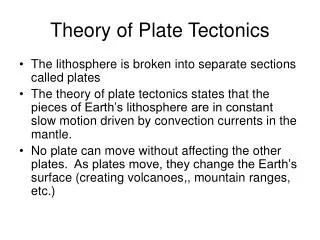
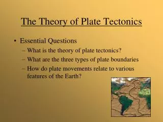
Theory of Plate Tectonics. 1. Continental Drift Theory. Alfred Wegener German meteorologist Found papers describing similar fossils on opposite sides of the Atlantic Researched more cases of similar organisms separated by oceans 1912 Proposed single supercontinent Pangaea.

E N D
1. Continental Drift Theory • Alfred Wegener • German meteorologist • Found papers describing similar fossils on opposite sides of the Atlantic • Researched more cases of similar organisms separated by oceans • 1912 Proposed single supercontinent Pangaea
2. Continental Drift Theory5 Types of Evidence • Fit of the Continents • Distribution of Fossils • Sequence of Rocks • Glacier Scraping Patterns • Ancient Climates and Wandering Polar Regions http://library.thinkquest.org/3669/media/map2dd.GIF
3. Wegener’s Continental Drift Evidence: • Continents ‘fit’ together in a single land mass 250 mya • CLICK Simulations http://www.ucmp.berkeley.edu/geology/anim1.html http://www.eoearth.org/upload/thumb/f/fb/Plate_tectonics_over_time.gif/400px-Plate_tectonics_over_time.gif
4.Wegener’s Continental Drift Evidence: Plant and animal fossils of the same species were found on several different continents.
5. Wegener’s Continental Drift Evidence: Similar sequence of rockor rock formations have the same age
6.Wegener’s Continental Drift Evidence: Glacial deposits, striations, and scraping patterns
7. Wegener’s Continental Drift Evidence: Climate distribution Past Present Coal exists under the ice in the rock of Antarctica – yet coal can only form from plants that grow in warm climates.
8. Wegener’s Theory Problems • Wegener had no convincing mechanism (did not explain the forces) of how the continents might move. Continents plowing through the crust would destroy the crust. • Continents are not moving apart at the speed Wegener proposed. Wegener = 250cm/yr Actual = 2 cm/yr
9. Holme’s theory: Heat trapped in the Earth caused convection currents in the mantle. Breakthrough theory that changed all thought on what was happening inside the Earth. • As a substance is heated its density decreases and rises to the surface until it is cooled and sinks again.
10. Convection Currents • Gravity causes the heated mantle to sink • The mantle heats up near the core and then rises again • Conduction is the transfer of heat between 2 materials in direct contact with each other library.thinkquest.org/C003124/images/convect.jpg http://www.wisc-online.com/objects/index_tj.asp?objID=SCE304 Click animation
Volcanic rocks on the seafloor have magnetization because, as they cool, magnetic minerals within the rock align to the Earth’s magnetic field. 11.New Evidence: Magnetic pattern of rock
15. Sea-Floor Spreading Hypothesis by Hess & DeitzIn the late 1950's, scientists mapped the present-day magnetic field generated by rocks on the floor of the Pacific Ocean. The volcanic rocks which make up the sea floor have magnetization because, as they cool, magnetic minerals within the rock align to the Earth's magnetic field. The intensity of the magnetic field they measured was very different from the intensity they had calculated. Thus, the scientists detected magnetic anomalies, or differences in the magnetic field from place to place. They found positive and negative magnetic anomalies. Positive magnetic anomalies are places where the magnetic field is stronger than expected. Positive magnetic anomalies are induced when the rock cools and solidifies with the Earth's north magnetic pole in the northern geographic hemisphere. The Earth's magnetic field is enhanced by the magnetic field of the rock. Negative magnetic anomalies are magnetic anomalies that are weaker than expected. Negative magnetic anomalies are induced when the rock cools and solidifies with the Earth's north magnetic pole in the southern geographic hemisphere. The resultant magnetic field is less than expected because the Earth's magnetic field is reduced by the magnetic field of the rock.
16. Sea Floor Spreading simulation CLICK Animation: http://www.uwsp.edu/geo/faculty/ritter/glossary/s_u/sea_flr_spread.html
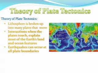
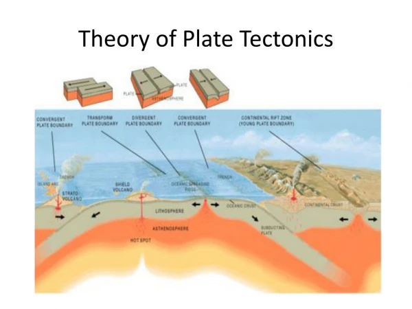
17. Plate Tectonics Theory Theory that Earth’s crust and rigid upper mantle (Lithosphere) moves Lithosphere is broken into slabs or plates that move independently from one another. Plates ‘float’ on the Asthenosphere Plates have oceanic and continental crust. www.wiley.com/college/herenow/ptect/pt-map1.gif
18. Earth’s Layers • Inner Core • Outer Core • Mantle • Crust • Atmosphere • Lithosphere – crust and upper mantle, plates move independently • Asthenosphere-region below the Lithosphere http://library.thinkquest.org/04oct/01724/images/Earth-crust-cutaway-english.png
19. Continental Crust • Cooling rate - slow • Crystal size - large • Density – less dense • Thickest portion of the Earth’s outer layer (20-30 miles thick. • Composition – made mainly of granite rock http://www.amonline.net.au/geoscience/images/earth_diagrams/cont_oceanic_crust.gif
20. Oceanic Crust • Cooling rate - fast • Crystal size - small • Density – more dense • Thinnest portion of the Earth’s outer layer • Composition – Made mainly of basalt rock http://faculty.weber.edu/bdattilo/parks/plume_ocean.jpg
21.Volcano - opening or rupture in the Earth’s crust that allows molten rock to escape http://cgz.e2bn.net/e2bn/leas/c99/schools/cgz/accounts/staff/rchambers/GeoBytes%20GCSE%20Bl og%20Resources/Images/Plate%20Tectonics/Plate%20Tectonics/VolcanoStructure.jpg
22. Earthquake - result of sudden energy release in the Earth’s crust creating seismic waves. • http://news.bbc.co.uk/nol/shared/spl/hi/world/04/earthquake/img/earthquake.gif
23. More Evidence: Location of mountain ridges, rift valleys, mid-ocean ridges, and trenches on plate boundaries. Convergent, Divergent and Transform http://www.ifa.hawaii.edu/~barnes/ast110_06/tprai/Tectonic_plate_boundaries.png SIMULATIONS ON ALL BOUNDARY TYPES CLICK http://www.pbs.org/wgbh/aso/tryit/tectonics/shockwave.html
There are 3 types of Plate Boundaries • Divergent Boundary • Convergent Boundary • Transform Boundary
24. Convergent Oceanic & Continental Andes MountainsPlates move toward each other. Denser oceanic crust subducts under less dense continental crust. A trench, a steep walled valley on the sea floor, forms here. blue.utb.edu/paullgj/images/Conv_Cont_Ocean.JPG CLICK http://www.pbs.org/wgbh/aso/tryit/tectonics/convergent.html
25. Convergent BoundaryOceanic & Continental CLICK http://geology.com/nsta/convergent-boundary-oceanic-continental.gif http://geology.com/nsta/plate-tectonics-cover.gif
26. Japan or Aleutian IslandsConvergent Oceanic & Oceanic Denser oceanic crust subducts under less dense oceanic crust ceeps.colostate-pueblo.edu/.../smM1P1Fig15.gif
27. Convergent BoundaryOceanic & Oceanic http://geology.com/nsta/convergent-boundary-oceanic-oceanic.gif
28. Convergent Continental & Continental: Himalayas Faulting and Folding http://www.pbs.org/wgbh/aso/tryit/tectonics/crush.html
29. Convergent BoundaryContinental & Continental http://geology.com/nsta/convergent-boundary.gif
30. Mid Atlantic RidgeDivergent Oceanic At a divergent boundary lithosphere plates move away from each other Example: Mid-Atlantic Ridge- North American Plate and Eurasian Plate are moving away from each other
31. Divergent Boundary - Oceanic • Mid-Ocean Ridges – a structure formed from seafloor spreading. Same as slide # 30 CLICK http://geology.com/nsta/divergent-boundary-oceanic.gif
32. East African Rift ValleyDivergent -ContinentalRift Valley – Pulling apart of continental crust due to tensional forces ceeps.colostate-pueblo.edu/.../smM1P1Fig15.gif
33. Divergent BoundaryContinental • Rift Valley http://geology.com/nsta/divergent-boundary-continental.gif
34. Transform Plate Boundary Plates slide past each otherEx: San Andreas Fault www.wiley.com/college/herenow/ptect/pt-map1.gif
35. Transform Boundary TRANSFORM SIMUALTIONS CLICK http://geology.com/nsta/transform-boundary.gif CLICK http://www.pbs.org/wgbh/aso/tryit/tectonics/transform.htm
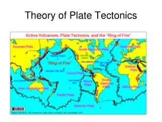
36. Evidence - Location of earthquakes and volcanoes http://vulcan.wr.usgs.gov/Imgs/Gif/PlateTectonics/Maps/map_plate_tectonics_world.gif
37. Ring of Fire • A dramatic example is the line of volcanoes that circles most of the Pacific Ocean. This belt is known as the "Ring of Fire" because it is the site of frequent volcanic eruptions. Volcanoes are also distributed in long belts that circle the Earth. • The distribution of earthquakes and volcanoes coincides at most locations. The Ring of Fire is an excellent example. Geologists believe that areas of intense geologic activity, indicated by earthquakes, volcanoes, and/or mountain building, mark the boundaries between lithospheric plates. The distribution of earthquakes, volcanoes, and mountain ranges define 7 large plates and 20 smaller plates. The Nazca and Juan de Fuca Plates consist of only oceanic lithosphere. The Pacific Plate is mostly oceanic lithosphere only a small slice of continental lithosphere in southern California and Baja Mexico. Most of the other plates consist of both oceanic and continental lithosphere.
38. Hot Spots – hot narrow plumes of magma that rise upr from the mantle and heat/melt an area of crust
39.The Hawaiian-Emperor volcanic chain is the result of the drifting of the Pacific Plate over a fixed hot spot. http://geology.com/nsta/plate-tectonics-cover.gif
40. The bend in the (Hawaiian – Emperor) volcanic chain is the result of a major change in the direction of the movement of the Pacific Plate.
41. Location of Hot Spots Hot spots result from hot, narrow plumes of material that rise deep within the mantle.
42. Plate Movement in the future • http://www.scotese.com/earth.htm It is even possible to measure the speed of continental plates extremely accurately, using satellite technology.
43. External Energy For Earth • Sun & Moon keeps air and sea in motion, shapes surface • Sun warms atmosphere & crust unevenly creating winds • Winds drive ocean currents and water cycle • Erosion from winds, rains, rivers, glaciers, and waves shape surface • Weathering from winds and rains • Sun & Moon Gravitational Energy, produces tides • Planetesimal collisions
44. Internal Energy for Earth • Radioactive element decay • Core heat from layers pressure • Convection currents • Volcanoes • Hot Springs • Earthquakes