Download

1 / 35
350 likes | 443 Views
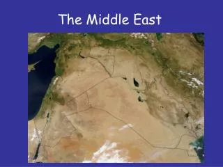
The middle east. The fertile Crescent. The Fertile Crescent is a crescent -shaped region containing the moist and fertile land of Western Asia , and the Nile Valley and Nile Delta of northeast Africa .

E N D
The fertile Crescent • The Fertile Crescent is a crescent-shaped region containing the moist and fertile land of Western Asia, and the Nile Valley and Nile Delta of northeast Africa. • The region is often called the cradle of civilization; it saw the development of many of the earliest human civilizations.
The Nile is the longest river in the world. The Tigris and Euphrates rivers flow to the southwest from Turkey into northern end of the Persian Gulf.
Tigris River http://www.youtube.com/watch?v=XC-fbKhmCro&safety_mode=true&persist_safety_mode=1 Euphrates River
Most of the soil in the desert regions of North Africa and Southwest Asia is not good for farming. It contains a lot of salt and sand.
Snow melts in the Turkish highlands, where the Tigris and Euphrates rivers begin. As a result, these rivers also flood yearly bringing fertile soil into the river valley.
Irrigation and the fertile crescent • Farmers in the area have developed irrigation methods or ways of bringing water to dry land. • http://www.britannica.com/EBchecked/topic/205250/Fertile-Crescent • https://www.youtube.com/watch?v=weqFW0xEh3g
The strip of fertile land begins along the Jordan River and curves through Southwest Asia to the Persian Gulf. • The Tigris and the Euphrates River flow through the eastern part of the region. Because the land is good for farming, the area is called the Fertile Crescent.
Crops in this region until recently, have been confined to the coastal zones, river valleys, and areas with in the Mediterranean climate. • Turkish farmers usually grow and produce crops such as: Cottons, tobacco, sugar beets, as well as some Livestock. • Iranians typically have the same crops but they, on the other hand grow them in the uplands.In the mountains of the Arabian Peninsula farmers typically produce Coffee, which was first domesticated in this region
Using your notes from yesterday • What area saw the development of many of the earliest human civilizations.? • What is the longest river in the world? • The ____________________________________rivers flow to the southwest from Turkey into northern end of the __________________________________. • Most of the soil in the desert regions of North Africa and Southwest Asia is not good for ____________________________. It contains a lot of ______________________________. • Snow melts in the Turkish highlands, where the Tigris and Euphrates rivers begin. As a result, these : • 6. The Tigris and the Euphrates River flow through the eastern part of the region. Because the land is good for farming, the area is called ______________________________________.
Continued • 7. Turkish farmers usually grow and produce crops such as: • 8. Iranians typically have the same crops but they, on the other hand grow them in the _________________________________________. • 9. In the mountains of the Arabian Peninsula farmers typically produce ___________________________, which was first domesticated in this region
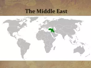
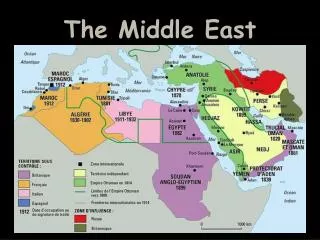
The major nation in this region is Iraq, with portions of Iran near the Persian Gulf, Kuwait to the south and Turkey in the north.
Map review Do Not Write on MAP Match the points of interest in the Middle East to its correct letter.
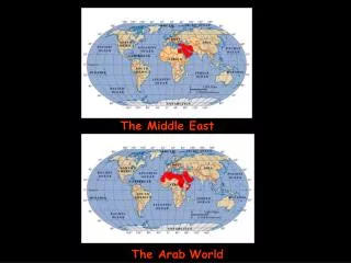
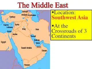
Crossroads of the world • The Middle East is called the Crossroads of the World because it lies at the intersection of three continents-Europe, Africa, and Asia.
Jordan River • Originates in the mountains of Israel, Lebanon, and Syria. • The Jordan flows into the dead sea. • Key water source for Israel, Lebanon, and Syria. • http://app.discoveryeducation.com/search?Ntt=jordan+river
Tigris and Euphrates rivers • Euphrates River flows into the Persian Gulf. Today Turkey, Syria, and Iraq compete for its water. • Tigris and Euphrates rivers are like twins running parallel to each other in some places
Strait of Hormuz http://www.youtube.com/watch?v=AyPINWwSMgA&safety_mode=true&persist_safety_mode=1 https://www.youtube.com/watch?v=fzPHAFk7aGc
Strait of hormuz • The Strait of Hormuz is a strait between the Gulf of Oman and the Persian Gulf. It is the only sea passage from the Persian Gulf to the open ocean and is one of the world's most strategically important choke points. • About 20% of the world's petroleum, and about 35% of the petroleum traded by sea, passes through the strait making it a highly important strategic location for international trade.[1]
Suez Canal • The Suez Canal is a source of income for the area. Ships use the canal to avoid long trips around southern Africa. Makes the canal one of the worlds busiest water way. • http://www.tripadvisor.com/LocationPhotos-g297543-d460012-w3-Suez_Canal-Port_Said_Port_Said_Governorate.html • http://app.discoveryeducation.com/search?Ntt=suez+canal • http://app.discoveryeducation.com/search?Ntt=suez+canal
Persian Gulf • Western countries call it the Persian Gulf , but most Arab countries call it the Arabian Gulf. • This shallow arm of the Arabian Sea between Iran and the Arabian Peninsula holds some of the most important oil fields in the world. • http://app.discoveryeducation.com/search?Ntt=persian+gulf
Gaza Strip West Bank Golan Heights http://app.discoveryeducation.com/search?Ntt=gaza+strip
Gaza strip The region of Gaza, a 25-mile long, 7-mile wide finger of land along the Mediterranean at the border between Israel and Egypt, has been at the center of geopolitical tug-of-wars for its entire existence.
Gaza was best known in ancient times for its strategic location as an important trading center for Asian, European and North African markets. The desirability of the territory resulted in frequent battles for its control.
The west bank Israel conquered the West Bank and Jerusalem in the June 1967 Six Day War. The proximate cause of that war was the Egyptian closure of the Strait of Tiran to Israeli shipping. The United Nations resolution creating Israel gave it a 5 mile coastline on the Gulf of Aqaba. It is bordered by four countries: Egypt, Israel, Jordan and Saudi Arabia.
Golan heights The Golan Heights is the area captured and occupied by Israel from Syria in the Six-Day War, which subsequently effectively annexed the territory in 1981. This region includes the western two thirds of the geological Golan Heights, as well as the Israeli occupied part of Mount Hermon.
Internationally recognized as Syrian territory, the Golan Heights has been occupied and administered by Israel since 1967.[1] It was captured during the 1967 Six-Day War, establishing the Purple Line.[11]
The United States considers the Golan Heights to be Syrian territory held under Israeli occupation subject to negotiation and Israeli withdrawal.
The heights give Israel an excellent vantage point for monitoring Syrian movements. The topography provides a natural buffer against any military thrust from Syria.