Download
1 / 16
160 likes | 176 Views
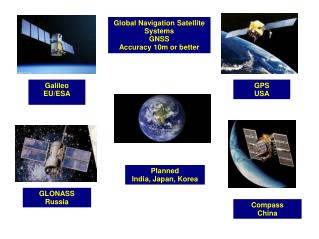
Global Navigation Satellite Systems Research efforts in Luleå. Staffan Backén, LTU Dr. Dennis M. Akos, LTU. Presentation Outline. Crash Course in GNSS (GPS, Galileo) Constellation Signal Structure Signal Processing Positioning – Accuracy - Augmentations GNSS in Space

E N D
Global Navigation Satellite SystemsResearch efforts in Luleå Staffan Backén, LTU Dr. Dennis M. Akos, LTU
Presentation Outline • Crash Course in GNSS (GPS, Galileo) • Constellation • Signal Structure • Signal Processing • Positioning – Accuracy - Augmentations • GNSS in Space • Research efforts in Luleå • Thesis - Phased Array Antenna • How? • Why 1 & 2 & example • Hardware Design – Dataset Recording • Research Status • Questions?
GNSS CC - GPS Constellation • Minimum 24 satellites • Period of 11 hours 58 minutes • Six circular orbits, • 20200km above the earth - MEO • Inclination angle of 55° relative to the equator • Passive system • Virtual stars
GNSS CC – Signal Structure • CDMA – All three systems (Glonass with a twist) • Modulation • GPS BPSK (QPSK) • Glonass BPSK • Galileo Boc(1,1), Boc(10,5), AltBoc(15,10) – not finalized • GPS transmitted and received power at L1: • Satellite antenna input ≈ 27W • Received power ≈ 5×10-14 W/m2 → Received signal below thermal noise floor
GNSS CC - Signal Processing • Acquisition • Find a specific satellite signal buried in noise • Code tracking • Decode time stamp • Carrier tracking • Decode data bits
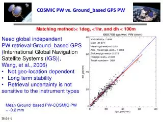
Positioning • Four satellites required for 3D position + time • Accuracy ≈ 7m RMS • Error sources • Multipath • Ionospheric, tropospheric delay • Ephemeris inaccuracies • Augmentation systems • SBAS • WAAS (America) • EGNOS (Europe) • MSAS (Asia) • DGPS, AGPS etc
GNSS in Space - Considerations • Software altitude/speed limit – commercial low cost receiver • To counteract missile development … 18000 m, 515 m/s • Roll issue • Antenna direction not fixed relative to the earth • Higher doppler • More extensive acquisition when traveling very fast • GNSS satellite antenna pattern • Directed towards earth • Predictable motion • Kalman filter
GNSS Antenna Arrays – why #1? Multipath
GNSS Antenna Arrays – why #2? Jamming
IF Data Recording Setup 8 • 2 bits 16.3676MHz Front end 1 • • • USB2 board Front end 8 33MB/s 16.3676MHz Rubidium oscillator
Antenna Array Layout • Groundplane • Aluminum • 1m diameter • Antenna elements • Commercial GPS patch antennas • Spacing • λ/2 ( ≈ 9,5 cm)
Research Status • Completed • Hardware design and implementation • Antenna array • USB2 transfer – hardware, firmware and host program • Dataset recording • Several dataset during a day • In progress • Verifying dataset • Antenna phase center determination • Coming up • Algorithm development • Adaptive algorithms, pre and/or post correlation beam forming • Future work • Interference mitigation • New hardware platform required …