Download
1 / 30
300 likes | 523 Views
Development of indicators of fire severity based on time series of SPOT VGT data. Stefaan Lhermitte, Jan van Aardt, Pol Coppin Department Biosystems Modeling, monitoring, and management of bioresponse Geomatics group KU Leuven Belgium. Outline. Global burn datasets:

E N D
Development of indicators of fire severity based on time series of SPOT VGT data Stefaan Lhermitte, Jan van Aardt, Pol Coppin Department Biosystems Modeling, monitoring, and management of bioresponse Geomatics groupKU Leuven Belgium
Outline • Global burn datasets: • GBA2000 (SPOT VGT data) • Globscar (AATSR) • Fire detection vs. quantification of impacts • General constants/biome • Essential • Global and regional carbon models • Understanding of vegetation recovery Multitemp 2005
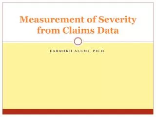
Objective Development of indicators to quantify spatio-temporal variation of fire impacts • Fire Severity (FS): “Percentage of the biomass per pixel that is burned“ Multitemp 2005
Data • Study area: South Africa • Satellite Data: SPOT Vegetation S10 • Year 2000 • 10-daily Maximum Value Composites (B, R, NIR, SWIR, NDVI) • 1x1 km² • Fires: GBA2000 Burnt Areas • Year 2000 • Monthly detected fire scars (no exact date, only month) • 1x1 km² Multitemp 2005
Fires • Indication of fire frequency by area • Very large fires exist, indicating a possible exaggeration Multitemp Multitemp 2005
Fires byvegetation type Large areas in (i) forest and woodland, (ii) thicket and bushland, (iii) shrubland and fynbos, (iv) unimproved grassland, and (v) cultivated commercial dryland Multitemp Multitemp 2005
Techniques • Spectral mixture analysis (SMA): • Bare soil, charcoal, vegetation Hypothesis: FSi ~ ∆(vegetation fraction)i where i = fire pixel --> Absolute values • Changes in vegetation indices (∆VI) Hypothesis: FSi ~ ∆(vegetation index)i where i = fire pixel --> Relative values Multitemp 2005
Spectral Mixture Analyis Assumes that the reflectance spectrum can be deconvolved into a linear mixture of the spectra of endmembers (pure pixels)
vegetation content pixel VFi = Spectral Mixture Analyis • Assumes that the reflectance spectrum can be deconvolved into a linear mixture of the spectra of endmembers (pure pixels) • Result: • relative abundance (fractions) of different endmembers for every pixel • when only 1 vegetation endmember is chosen, the fractions reflect an absolute measure of • FSi be expressed by ∆(VFi) Multitemp 2005
Spectral Mixture Analyis Procedure Endmember selection • ‘Iterative Error Analysis’ (IEA) (Neville et al., 1999) • An automated selection procedure • Grouping of all burnt pixels • 3 observations before fire • 3 observations afterwards • Selection of desired endmembers • Assumption that endmember spectra are time invariant • Only correct estimation for the ‘Forest and Woodland’ Type Multitemp 2005
Spectral Mixture Analyis Procedure • Typical reflectance of 3 endmembers: Vegetation, dark wet soil (or charcoal), and light or dry soil • Problem: IEA could only retrieve meaningfull endmembers for the Forest and Woodland landcover type Multitemp Multitemp 2005
Spectral Mixture Analyis Procedure • Endmember selection • Fraction images Multitemp 2005
Spectral Mixture Analyis Procedure % Vegetation Component3 decades before fire Multitemp Multitemp 2005
Spectral Mixture Analyis Procedure % Vegetation Component3 decades before fire Multitemp Multitemp 2005
vegetation content pixel ∆Vegetation Index • Assumes that the FS can be expressed by ∆(VI) • VI: • no absolute measure of vegetation quantity • related to vegetation but have phenological fluctuations • cannot be used for FS without normalization Multitemp 2005
∆Vegetation Index • Normalization: • use relative index (RI) to reduce phenological influences • reference areas: areas located adjacent or close to the burned sites, but not affected by the disturbance. They should have similar environmental conditions and vegetation Multitemp 2005
Analysis • Look at a fire as a complete entity: • Analysis of mean(FSi)jwhere i = fire pixelj = fire id • Look at spatial variability for every fire: • Analysis of FSiwhere i = fire pixel Multitemp 2005
Spectral Mixture Analyis(fire.id) • Change curves of fractions for every fire scar (Example 1) Multitemp Multitemp 2005
Spectral Mixture Analyis(fire.id) • Change curves of fractions for every fire scar (Example 2) Multitemp Multitemp 2005
∆Vegetation Index(fire.id) Change curves of ∆VI for every fire Scar (Example 1) Multitemp Multitemp 2005
∆Vegetation Index(fire.id) Change curves of ∆VI for every fire scar (Example 2) Multitemp Multitemp 2005
SMASpatial variability of every fire Dark soil Vegetation Light soil ∆VI Multitemp 2005
Actual Fire Severity • FS can now be derived from change detection of the derived data sets • Change detection on the RI-images before and after fire • Change detection on the fraction images of the vegetation component before and after fire • E.g.: Image differencing was performed and the FS was calculated for both techniques Multitemp 2005
Validation • Fire records of Kruger National Park (KNP) • Validation of FS with field data containing burn severity • Statistical regression techniques to assess the performance of both techniques and the resulting quantitative indicators of burning efficiency • Results were unsatisfactory • Possible errors: endmembers, reference areas • KNP fire records are very subjective • Additional validation is necessary: • severity indices Landsat imagery Multitemp 2005
Conclusion • Two techniques to quantify spatio-temporal variation of the impact of fire were presented • Additional validation is necessary Multitemp 2005
Acknowledgements • Funding provided by the Belgium Science Policy Office (BELSPO) as part of the GLOVEG project • Jan Verbesselt for scientific inputs Multitemp 2005
stefaan.lhermitte@biw.kuleuven.beLaboratory of Geomatics KU LeuvenVital Decosterstraat 102, 3000 Leuven Belgium