Download
1 / 31
400 likes | 611 Views
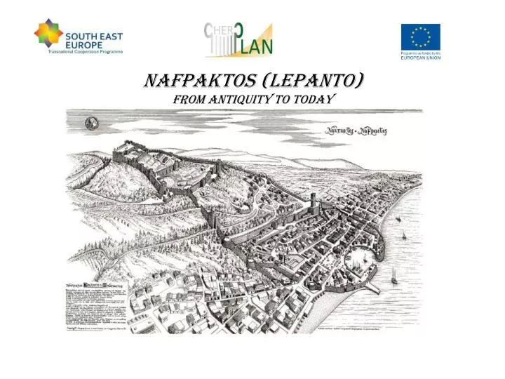
NAFPAKTOS (LEPANTO) from antiquity to today. NAFPAKTOS EXISTS FROM ANCIENT TIMES, more than 3000 year’s of history (NAFS)+(PIGNIMI)=NAFPAKTOS or “where ships are built” CASTLE CITY OF LEPANTO IN MEDIEVAL TIMES 1571 THE NAVAL BATTLE OF LEPANTO (07.10.1571) EPACHTOS FOR THE OTTOMANS

E N D
NAFPAKTOS EXISTS FROM ANCIENT TIMES, more than 3000 year’s of history • (NAFS)+(PIGNIMI)=NAFPAKTOS or “where ships are built” • CASTLE CITY OF LEPANTO IN MEDIEVAL TIMES • 1571 THE NAVAL BATTLE OF LEPANTO (07.10.1571) • EPACHTOS FOR THE OTTOMANS • FROM 1829 IS PART OF THE NEW HELLENIC STATE
1838-1937 The City of Nafpaktos as a Castle City • 1838 Greek and Bavarian Engineers survey the City and Castle plan and street layout of Nafpaktos • For 16 of 20 ha of the Castle stretches the city plan • no road infrastructure for intercity connections • all commercial contacts made via boat or carriages • City gradually expands more to the east rather than the west reaching the streams of Skala and Lagadoula
1922 and 1937 the Castle of Nafpaktos (Lepanto) is declared as a listed Monument of Greece • 1935 The Reforestation of the Castle of Nafpaktos (Lepanto) is decided • 1937 The city plan expands to the currents Skala and Lagadoula (100 ha total) 1937 to 2013 Nafpaktos as a modern City • 1949 Nafpaktos is declared as a Touristic Area • 1955 The main road that crosses the city is categorized as a National road • 1955 The city expands towards the north at Evraiolakka (2 ha) • 1962 The Port Land Zone is defined an reaches the whole of the two bays
The critical 20 years of Nafpaktos • 1973 Nafpaktos is declared as an Historic Land, and a Land of Significant Natural Beauty • 1973 The highway that connects DeIphi with Antirrio is designed but in the area of Nafpaktos was never constructed • 1974 The city plan of Lygias Newcastle is issued (65 ha) • 1976 The city is declared as a Touristic Area • 1977 The city plan of Kastraki Paliopanagias is issued (5,5 Ha) • 1978 The city plan of Nafpaktos expands to the east and west (85 ha) • 1978 The city of Nafpaktos is declared as a Traditional Settlement • 1980 The city plan expands to the north at the area of Alonaki Varnarachi and Leptokaritika (10 ha) • 1981 The Municipal Office of City Planning • 1988 The General City Planning is issued, determining uses and future city expansions • 1993 The limits of the city’s Traditional Settlement is defined (112 ha)
1998 The Nafpaktos Marina is determined at the Gribovo bay • 1998-2002 The Housing/Building code issue • 1985 -2002 expropriation of 11 private ownerships for the restoration of the Castle by the Ministry of Culture • 2003 The Region of Western Greece development plan • 2004 The new highway by pass goes in use • 2005 The Nafpaktos city plan expands to east and west (100ha) • 2008 The Specified Regional Planning of Greece is announced • 2009 The Specified Regional Planning for Tourism of Greece is announced • 2011 The Archaeological zone of the Castle of Nafpaktos is defined • 2011 The Historic land of Nafpaktos is determined • 2012 The New General City Planning commences
In the majority of the Traditional Settlement (112 ha) the traditional architecture characteristic has been lost due to the Housing/Building Code Issue • The total city plan for Nafpaktos and its suburbs are 367,5ha where up to today more than half of it has not been applied and implemented. The needs for housing and development area has been absorbed by either upward development or at areas, suburbs and settlements with out city planning (Paliopanagia, Mamoulada) • The local authorities throughout the years unable to handle the cost of opening the city to its determined limits are the first to blame for the environmental degradation • Nevertheless many things can be changed and reversed to a more reasonable way of development
The City of Nafpaktos (Lepanto) modern prospects and advantages: • the rich cultural heritage of 3000 years • the rich natural heritage of the city and the whole of the Municipality • the increasing touristic interest • the celebration of the “Naval Battle of Lepanto of 1571” • the completion of large infrastructure projects (the Rion-Antirrion Bridge) • the city is located at the midpoint of the Ancient Olympia and Delphi connection • the steady growth the yachting tourism towards the Ionian Sea • the future development of the Olympia and Ionian highways
The City of Nafpaktos (Lepanto) modern problems: • the cultural heritage depreciation • the local traffic and the traffic organization of the city • the undeveloped touristic infrastructure (Hotel Xenia, Nafpaktos Marina) • the old ottoman sewage distribution system, the city's old water supply system, the over head electricity distribution system • the non development of the city planning • the lack of sufficient school buildings • the design of the city’s highway by pass
Nafpaktos Urban development plan titled : “Urban Regeneration of the Castle City of Nafpaktos by upgrading the City’s Residential Wings” Main goals: • The Enhancement of the Castle City and the Ancient City area • The connection of the City Centre with the seafront and both bays between them via pedestrian routes • The regularization of the urban traffic and transportation • The environmental upgrading of the city wings • The modernization of the city’s infrastructure
Urban Traffic and Transportation problems of Nafpaktos • The two main roads that pass through the City Centre and Castle and are in great distance to the highway by pass (no ring road) • The geometric characteristics of the streets reach up to 10m width • No areas for parking spaces and insufficient public transportation • Incomplete bicycle routes Urban Traffic and Transportation solutions of Nafpaktos • Two way streets are studied to covert to one way • New pedestrian and bicycle routes and new bicycle rent system • Locating new parking areas and revising public transportation • Planning of a new ring road within the New General City Planning
The areas of cultural heritage in today Nafpaktos City: • The Medieval Venetian Castle City • The area of the Castle’s Archeological Zone • The area of the Varnarachi, Tsoukari and Saint George hills • the Listed Monument and Building land marks • The 19th and early 20th Century buildings that are found mainly via the commercial roads All are linked via the “Culture Heritage Path of Nafpaktos”
Significant Monuments in the Castle’s two lower levels The Fetihye Mosque and Park of Miguel Cervantes The Mansion of Botsaris and the Mansion of Trikkaiou The Castle Clock and the Mansion of Tzavella The Vezir Mosque, the Minaret ruins and the Ottoman baths Numerous fountains and cobbled roads Significant Monuments in the rest of the Archaeological Area of Nafpaktos The Asklipiio of Tsoukari Listed buildings Numerous archaeological excavations and fountains
Projects that are developing • The urban project of the East City Centre with reconstruction of the water supply, sewage distribution system and new electricity distribution network • The “Cultural Heritage Path” of Nafpaktos • The New Centre of Touristic Information at the building “Nafpaktia” in the Venetian Port Area • The New Speech and Arts Centre at the building “Tsonis” in the area of Psani bay • The New Centre of Naval Arts at Gribovo bay, next to the situated Marina Area • The renewed traffic and transportation map of the city
Urban Planning • The urban landscape design of the 3 hills in the east of the City (Varnarachi, Tsoukari, St. George) • The urban project of the West City Centre with reconstruction of the water supply, sewage distribution system and new electricity distribution network • The urban project of the Historic City Centre with reconstruction of the water supply, sewage system and new electricity distribution network • The urban landscape planning of the City’s Cultural Park in the area of Vatovrysi • The urban landscape design of the Port land area which will connect the two bays via the Castle • The urban landscape design of the Port Land Area around the Marina area
Conclusion • Insufficient and unconcluded planning in urban areas give degradation of their comparative advantages • In the case of Nafpaktos the cultural and natural heritage suffered the most • When in the other hand when enhanced could give economic development with tourism and everyday quality. Environmental planning that will aim in the regeneration of the City’s Historic Identity is a task that especially under these economic and political conditions most be an unanimous target of all.
In behalf of the Municipality of Nafpaktia and the honorable Mayor Mr. Ioannis Mpoules we welcome you and thank you Konstantinos Patouhas Civil Engineer Scientific Consultant of the Mayor of Nafpaktia