Download
1 / 10
200 likes | 1.19k Views
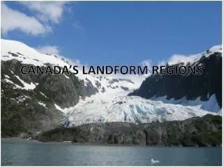
Canadian Landform Regions. Landforms. -> Landforms are the topography , or natural features, of the land's surface. -> Landscape is an area's landforms + its cover of vegetation, water, ice and rock -> Topography may be described in the following terms:

E N D
Landforms -> Landforms are the topography, or natural features, of the land's surface. -> Landscape is an area's landforms + its cover of vegetation, water, ice and rock -> Topography may be described in the following terms: - Elevation (height above sea level) - Geology (types of rocks and history of those rocks) - General Appearance (landform descriptions. Ex. Mountains may be young, sharp peaks and steep ridges; or old, rounded and worn down)
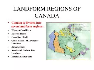
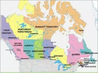
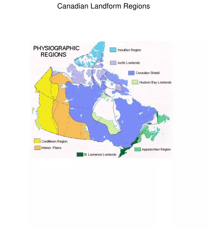
Canadian Shield ·Age of Rock: about 4 billion years old: Precambrian Era ·Type of Rock: varies - mountains, plains, much of which is now sediment and pushed around to other areas of N.A. through glaciers and plate movement ·Soil is thin and acidic, good for forests, but not for agriculture except where deposits left by glaciers ·Process to shape area: moving water and ice through glaciers and plate movement ·Area: parts of Sask., Manitoba, Ontario, Quebec, Labrador, NWT and Nunavut ·Human Activity:
Appalachian Mountains ·Age of Rock: Approx. 375 million years, N.A. and Eurasia plates collided: Paleozoic Era ·Type of Rock: Deposits in valleys have developed deep, fertile soils. ·Process to shape area: worn down by ice and water with rolling hills and broad valleys ·Area: Most of Atlantic Canada ·Vegetation: ·Human Activity: Cape Breton highlands flattened by erosion Wide, eroded valleys Wide, low valleys with low, rounded mountains (Cape Breton)
Western Cordillera ·Age of Rock: formed during Cenozoic era ·Type of Rock: many soils are rich and fertile due to sand and silt deposited by rivers, especially in delta areas ·Process to shape area: young mountains, steep, separated by plains. ·Area: B.C., Yukon, part of Alberta ·Vegetation: ·Human Activity: U-shaped valley in Jasper Park Coastal Mountain in B.C. Rocky Mountains
Innuitian Mountains ·Age of Rock: formed during Mesozoic era (younger than Appalachians) ·Type of Rock: soil not great or fertile. Too cold in area for trees ·Process to shape area: erosion has not yet worn down mountains. ·Area: Far north areas of Canada, including Ellesmere island ·Vegetation: ·Human Activity: Red rocks and barren landscape on Melville Island Glacier on Ellesmere Island Innuitian Mountains
Arctic Lowlands ·Age of Rock: Mesozoic Era ·Type of Rock: upland plateaus and lowland plains ·Process to shape area: area of tundra, a treeless plain, with a cold dry climate and poorly drained soil ·Area: Far north areas of Canada, south of the Innuitians ·Vegetation: ·Human Activity: Prince Patrick Island in NWT Tundra in Nunavut Arctic Lowlands
Interior Plains ·Age of Rock: early Paleozoic to Cenozoic Eras ·Type of Rock: rich soil up to 25cm deep, ideal for wheat ·Process to shape area: created when inland seas receded ·Area: Most of Alberta, Sask, Manitoba and NWT (and south to the Gulf of Mexico) ·Vegetation: ·Human Activity: Farmland near Red River Interior Plains Cypress Hills in Sask.
Hudson Bay Lowlands ·Age of Rock: Paleozoic era ·Type of Rock: Paleozoic rock to depths of 2000m ·Process to shape area: poor drainage leads to swampy forests, tundra and bog (referred to as Muskeg) ·Area: Within the Canadian Shield, areas of Northern Ont. and Manitoba ·Vegetation: ·Human Activity: Watery terrain outside Churchill, Manitoba Muskeg A forested bog outside Gillam, Mb.
Great Lakes-St. Lawrence Lowlands ·Age of Rock: formed in the Paleozoic era ·Type of Rock: some volcanic and faulting action left fractures in crust, with harder rock types, but mainly sand and clay - fertile soil called 'brown earth' ·Process to shape area: was flooded by the Champlain Sea 10 000 yrs ago, then drained, leaving good base for soil ·Area: from Southwestern Ont. along the St. Lawrence River to the mouth of the Sagueny River in Quebec ·Vegetation: ·Human Activity: Some escarpments were created by faulting, with drops in the land - the Niagara escarpment is the most famous. Farmlands in Ontario City of T.O. - note the lack of hills in the area.