Download
1 / 10
100 likes | 199 Views
AV Training Presentation 8 Taking and reporting a Fix to a Government Agency. Elements of a Fix Report 1. Charted Fix – check taken from the NOAA Chart as a comparison. 2. Accuracy – Horizontal Datum 3. Read out format from the GPS in degrees, minutes and seconds.

E N D
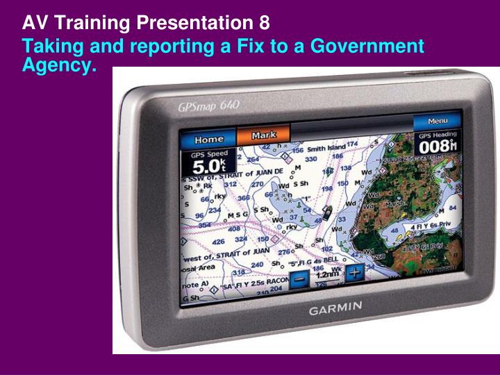
AV Training Presentation 8 Taking and reporting a Fix to a Government Agency.
Elements of a Fix Report 1. Charted Fix – check taken from the NOAA Chart as a comparison. 2. Accuracy – Horizontal Datum 3. Read out format from the GPS in degrees, minutes and seconds. 4. Quality – EPE – Estimated Position Error or HDOP – Horizontal Dilution of Position. 5. Date and time taken.
1. List the manufacturer’s name and model number of the GPS on your NS-PN04 Private Aid to Navigation Report. Initial set up requirements Or, add this information to your “Accuracy Statement” for use on the Web-Based PATON System.
Sample “Accuracy Statement” GPS 76 by GARMIN with WAAS enabled in 3D Differential was used for fix. GPS was pre-checked at the dock with another GPS set. On-scene EPE was 6.7 feet. Wide 100 echo sounder by Hummingbird that was pre- checked at the dock with a lead line. Substation used was Neponset River. Correction for transducer was 0.9 ft. White= Data normally stays the same while you are on your own OPFAC. Yellow = As you move around, this data will change for each verification.
Perform a pre-underway check of the GPS. • Confirm that the horizontal datum on the GPS matches the horizontal datum used on the NOAA chart. • 2. Insure that the GPS is operating accurately by checking it against: • a. A known location. • b. Another GPS or by • c. A fixed object on a NOAA chart.. • Establish the “EPE” is reading under 20 feet in 3D Differential. • 4. Update your “Accuracy Statement”
1. Take the FIX while close aboard the PATON while in the channel. 2. Record the FIX from the GPS. 3. Record the date and time when the depth was taken. 4. Record the EPE or HDOP from the almanac screen on your GPS. 5. Plot the FIX on your NOAA chart. 6. Record the Fix for the PATON. Taking a FIX for a PATON
Your recorded depth: 25.3 feet PLUSCorrection for transducer: 0.9 feet MINUSHOT- Height of Tide: 2.5 feet EQUALSEstimated Depth at Datum23.7feet Compare Estimated Depth at Datum to Charted Depth. Make a statement in the Comments Section, if needed. Correcting the depth to charted datum
Update the observed sounding data to the “NS-PN04 Private Aid to Navigation Report.” Accuracy Statement Update for the “Web-based PATON System”
AV Task Enter the depth data on the your NS-PN04 Private Aid to Navigation Report. Sounding - 23.5 feet. Transducer correction – 0.9 feet. Height of tide - 2.5 feet. Charted depth – 24 feet. Calculate Estimated Depth at Datum. Calculate Depth Difference (Estimated Depth at Datum versus Charted Depth.)