Download
1 / 15
150 likes | 154 Views
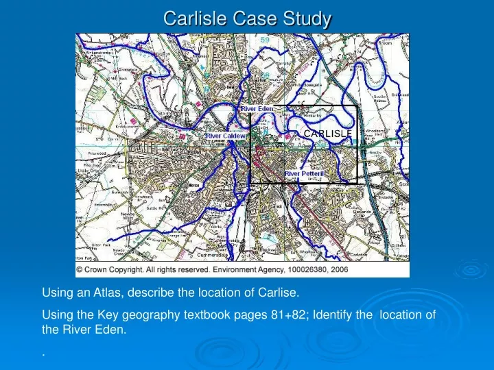
Carlisle Case Study. Using an Atlas, describe the location of Carlise. Using the Key geography textbook pages 81+82; Identify the location of the River Eden. Carlisle Case Study.

E N D
Carlisle Case Study Using an Atlas, describe the location of Carlise. Using the Key geography textbook pages 81+82; Identify the location of the River Eden. .
Carlisle Case Study • Carlisle is situated on the flood plain of the River Eden with three rivers meeting in the city. The catchment covers approximately 2400km2 and is home to approximately 244,000 people. The catchment is mainly rural, with only 1% classified as urban: the main urban areas are Carlisle, Penrith and Appleby.Carlisle has a history of flooding with flood events recorded as far back as the 1700s. In recent years there have been significant floods in 1963, 1968, 1979, 1980, 1984, and recently in 2005. Across the catchment, the January 2005 flooding affected 2,700 homes. In Carlisle three people died, 1,844 properties were flooded and there was significant disruption to residents, businesses and visitors. The cost of the flooding was estimated at over £400 million. The flooding followed prolonged heavy rain, and was caused by a combination of floodwater from the Rivers Eden, Pettereril and Caldew and localised flooding from sewers and road drainage.
Carlisle Case Study • The catchment of the River Eden is in Cumbria, rising in the hills of the Lake District. It reaches the sea at the Solway Firth. The catchment is made up of the Rivers Eden, Eamont, Irthing, Petteril and the Caldew, as well as smaller rivers and streams draining into the Eden estuary.
Carlisle Case Study • The upper parts of the catchment are dominated by the mountains of Skiddaw and the surrounding fells. The rocks here are hard and volcanic, soils are thin and the gradients of many tributaries are steep, so these watercourses have a rapid run-off response to flooding. In the lower reaches rivers flow through wide, shallow valleys. The Eden channel itself has a steep gradient upstream of Kirkby Stephen. The head of the catchment is around 690m, falling rapidly to 160m at Kirkby Stephen. Below Kirkby Stephen, the Eden's glaciated valley opens out and the channel gradient reflects this change: the River Eden steadily loses height at around 1.8m per km to Appleby at 123m some 21km downstream. From Appleby, the Eden continues through the lowland valley to Carlisle, 9m, falling at a fairly constant rate of 1.4m per km over its 80km journey from Appleby. The valley floor is over 2.5 km wide in many places. This forms extensive areas of floodplain washlands which are an important feature of the catchment. • Hydrology • In the Eden catchment there is a significant contrast in mean annual rainfall between the upstream and downstream ends of the catchment, related to the topography of the catchment. • In the upland tributaries upstream of Penrith in the Eamont catchment, average annual rainfall exceeds 2800mm on Helvellyn • Around Carlisle and on the coastal fringe, this is reduced to about 760mm • The average annual rainfall for England and Wales is 920mm.
Carlisle Case Study • In the steep upper catchments the topography, combined with the geology, leads to fast responses to rainfall: • In Kirkby Stephen, the River Eden will respond to rainfall in around 1.5 hours The time taken for rain falling on the top of Helvellyn, the highest point in the Eamont catchment, to reach Ullswater Lake is around 2 hours • In the lower catchment, with mainly lower gradients and deeper soils, the flood responses are slower.
The January 2005 flood was a major event. Rainfall was very high for the period 6 to 8 January, during which two months' worth of rainfall were released in 24 hours. However, it followed a month of high rainfall in the Carlisle area, so the ground was saturated and would no longer allow water to infiltrate, and surface run-off was excessive. The result was rapidly rising water levels in a number of rivers including the Eden.
Affects of the flooding • http://www.geography.org.uk/download/GA_FloodingCarlisleDepthSequence.gif
Carlisle Case Study • Tasks • 1 Annotate the hydrograph to show you understood these terms: rising limb, falling limb, peak flow rate, lag time, recessional limb • Read the text: What was the hydrology of the January 2005 flood? Then add text boxes to the hydrograph with brief notes about key aspects of the flooding - use the dates on the hydrograph to help you. • Using the map in the text book, use map evidence, explain the physical and human factors which may have contributed to the flooding in Carlisle. 6 marks • Using the hydrograph and your understanding of the drainage basin characteristics of the River Eden, describe and account for the flood hydrograph shown for January 2005. 10 marks
Carlisle Case Study • Physical Factors • Low lying flood plain less than 20m • Many tributaries joining the Eden e.g. River Petteril 412564 • Lack of evidence of vegetation on the map, this limits interception rates. • Higher than average rainfall • High drainage density • Human Factors • Homes built on the floodplain (wet point site) Edentown 3957 • Levees along river banks may have been artificially strengthened • Recreational activities deliberately built on the floodplain e.g. golf course 414565 • Impermeable surfaces increasing surface run-off created by the urban environment of Carlisle. • Sewage works at 320505