Download
1 / 1
20 likes | 245 Views
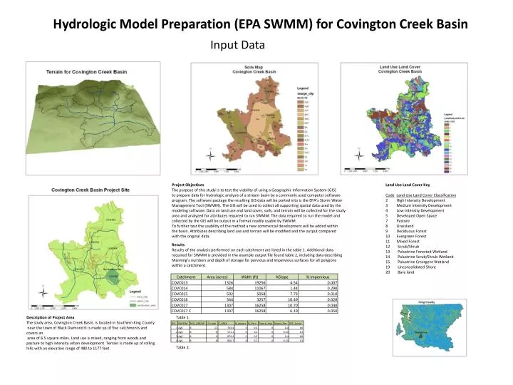
Input Data. Hydrologic Model Preparation (EPA SWMM) for Covington Creek Basin. Project Objectives The purpose of this study is to test the viability of using a Geographic Information System ( GIS) to prepare data for hydrologic analysis of a stream basin by a commonly used computer software

E N D
Input Data Hydrologic Model Preparation (EPA SWMM) for Covington Creek Basin Project Objectives The purpose of this study is to test the viability of using a Geographic Information System (GIS) to prepare data for hydrologic analysis of a stream basin by a commonly used computer software program. The software package the resulting GIS data will be ported into is the EPA’s Storm Water Management Tool (SWMM). The GIS will be used to collect all supporting spatial data used by the modeling software. Data on land use and land cover, soils, and terrain will be collected for the study area and analyzed for attributes required to run SWMM. The data required to run the model and collected by the GIS will be output in a format readily usable by SWMM. To further test the usability of the method a new commercial development will be added within the basin. Attributes describing land use and terrain will be modified and the output compared with the original data. Land Use Land Cover Key CodeLand Use Land Cover Classification 2 High Intensity Development 3 Medium Intensity Development 4 Low Intensity Development 5 Developed Open Space 7 Pasture 8 Grassland 9 Deciduous Forest 10 Evergreen Forest 11 Mixed Forest 12 Scrub/Shrub 13 Palustrine Forested Wetland 14 Palustrine Scrub/Shrub Wetland 15 Palustrine Emergent Wetland 19 Unconsolidated Shore 20 Bare land Results Results of the analysis performed on each catchment are listed in the table 1. Additional data required for SWMM is provided in the example output file found table 2, including data describing Manning’s numbers and depth of storage for pervious and impervious surfaces for all polygons within a catchment. Description of Project Area The study area, Covington Creek Basin, is located in Southern King County near the town of Black DiamondIt is made up of five catchments and covers an area of 6.5 square miles. Land use is mixed, ranging from woods and pasture to high intensity urban development. Terrain is made up of rolling hills with an elevation range of 480 to 1177 feet. Table 1. Table 2.