Download
1 / 11
120 likes | 380 Views
Mobile GPS tracking system using STRATO. Holger Vömel University of Colorado, CIRES and NOAA/CMDL. Mobile GPS tracking system using STRATO. Huntsville soundings : November 1, 2002 November 2, 2002 Payload: NOAA Frost-point hygrometer ECC ozone sonde Snow White hygrometer GPS

E N D
Mobile GPS tracking system using STRATO Holger Vömel University of Colorado, CIRES and NOAA/CMDL
Mobile GPS tracking system using STRATO Huntsville soundings : November 1, 2002 November 2, 2002 Payload: NOAA Frost-point hygrometer ECC ozone sonde Snow White hygrometer GPS Vaisala radiosonde
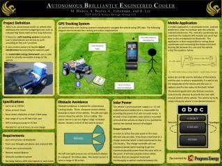
Mobile GPS tracking system using STRATO • Mobile tracking components: • Magnet mount roof antenna • Receiver • Modem • Laptop computer (data) • GPS receiver • Laptop computer (navigation) • Mobile power supplies, wiring, interfaces
Mobile GPS tracking system using STRATO Navigation computer using Topo USA MobileGPS receiver Balloon telemetry with GPS position GPS multiplexer Mobile ground station Data computer using STRATO with GPS coding
Mobile GPS tracking system using STRATO • Strato real time processing • Pre-launch landing prediction using radiosonde profiles • Real time NMEA output of balloon location • Additional real time NMEA output of landing prediction (on descent) • Estimated time to landing
Mobile GPS tracking system using STRATO • Landing prediction uncertainty: • Pre-launch : ~ 50 km (assuming the balloon does not burst prematurely) • burst (45 min remaining) : ~ 30 km • 6 km on descent (20 min remaining ) : ~10 km • 2 km on descent (8 min remaining) : < 3 km
Mobile GPS tracking system using STRATO • Recovery options: • Pre-launch predicted range < 150 km: Recovery by launch team, predicted landing site can be reached during time of ascent • Pre-launch predicted range > 150 km: Recovery by second car with head start, or very good chances for launch team in flat terrain.
Mobile GPS tracking system using STRATO • Caveats: • Need to plan for recovery route before launch, using weather service radiosoundings. • Need to plan for topography in difficult recovery situation, i.e. may have to record signal from far high ground. • Signal should be recorded from launch site (or DSRC!) to avoid drop outs. • Need cell phone communication