Download

1 / 35
350 likes | 485 Views
130 miles south of orlando. St. Lucie County. Atlantic Ocean. Lake Okeechobee. 100 miles north of miami. Taylor Engineering, Inc. Advancement of an Enterprise Coastal GIS in Martin County, Florida. Alexandra Carvalho, Ph.D. Kathy Fitzpatrick, P.E. Rob Hudson, AICP. Palm Beach County.

E N D
130 miles south oforlando St. Lucie County Atlantic Ocean Lake Okeechobee 100 miles north ofmiami Taylor Engineering, Inc. Advancement of an Enterprise Coastal GIS in Martin County, Florida Alexandra Carvalho, Ph.D. Kathy Fitzpatrick, P.E. Rob Hudson, AICP Palm Beach County
Land Area - 556 sq. miles Population - 131,617 Municipalities - 4 5 Commission District JENSEN BEACH NORTH RIVER SHORES STUART HUTCHINSON ISLAND St. Lucie County SEWALL’S POINT PALM CITY PORT SALERNO Atlantic Ocean TROPICAL FARMS HOBE SOUND JUPITER ISLAND INDIAN TOWN Lake Okeechobee Palm Beach County Martin County FACTS OCEAN BREEZE PARK
NS -Site 1 NS -Site 2 NS -Site 3 Sirotkin Reef Donaldson Reef Ernst Reef St. Lucie Inlet Evans Crary Bridge Coastal Programs • 22 Miles of Coastline • 2 Long Term Beach • Renourishment Projects • Federal Inlet Maintenance • Program • 2 Major Inland Waterways • Many Federal, state and • Local Waterfront Parks • Active Artificial Reef Program Atlantic Ocean
Support the management of the habitat, beach, waterway, and artificial reef programs Manage project budgets Manage and track permit and grant requirements Automate the permit and grant application submittals Objectives
Support the management of the habitat, beach, waterway, and artificial reef programs Manage and analyze monitoring data and scientific model results Community outreach to Federal and State agencies, scientific and engineering communities, public. Plan Coastal Programs Future Objectives
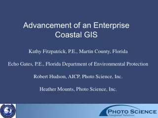
Web Portal User Community Search/Query Tools RESTRICTED ACCESS Mapping Tools Public Reporting Tools Scientific and Engineering Community Data Distribution Tools Contractors Proposed Project Partners UNRESTRICTED ACCESS Martin County Engineering Department Coastal Management Toolset Proposed Proposed Contact Manager Enterprise Approach to User Community Artificial Reefs Program Manager data Integrity, standards Beach Management Program Manager and protocols UNRESTRICTED ACCESS Waterway Maintenance Program Manager Martin County Engineering Department Habitat Management Program Manager Project Manager Funding Manager Coastal Geodatabase Grant Manager User Community Permit Manager Financial Future FEATURE DATASETS Data Manager Integration In pilot database Database Feature Classes UNRESTRICTED ACCESS Map Manager Martin County Engineering Department RELATIONSHIPS RESTRICTED ACCESS BUSINESS TABLES Contractors Financial Database Program Toolset Project Toolset Toolset RASTER DATASETS Georeferenced Imagery Microsoft Outlook TM Contact Manager Coastal Information Management System
2002 - 2003 2004 2005 PHASE III PHASE I PHASE II PHASE IV PHASE V PHASE VI MARINE DATA MODEL SCOPING ASSESSMENT PROTOTYPE PRODUCTION SYSTEM MAINTAIN & ENHANCE IMPLEMENTATION Completed Timeline
Deliverables Contractor Delivers Final Product Contractor Completes Task Apply for Site Project Funds Permit Site Permit Program Site Boundary Established Allocated Granted Funds Program Site Available Project Site Boundary Established Permitted Coastal Project Find Funding Management County Budget Regulatory Project Permit Events Tasks and Grants Project Agencies Granted Planned and Activity Project Apply for Project Required Breakdown County's Coastal Permitted Permit Project in Tasks Division Activities Coastal Programs Hire Contractor Hire Contractor Service Providers Find Service Providers General Business Processes
Needs Assessment Meetings Program and Project Management Requirements Permit and Grant Management Requirements Regulatory Agency Data Submission Requirements Data Inventory and Organization by Program Area Basemap Spatial Data Project Spatial and Non - Spatial Data Monitoring Spatial and Non - Spatial Data Design and Implementation of Geodatabase Structure and Schema Scoping Phase
Scoping Phase Geodatabase Structure • Domains • Business • Tables • Feature • Classes • Relationships
Scoping Phase • Extent • Projection
Needs Assessment Meetings Program and Project Management Requirements Permit and Grant Management Requirements Regulatory Agency Data Submission Requirements Data Inventory and Organization by Program Area Basemap Spatial Data Project Spatial and Non - Spatial Data Monitoring Spatial and Non - Spatial Data Design and Implementation of Geodatabase Structure and Schema Development of User Interface and Artificial Reef Program Tools Scoping Phase
Enterprise Geodatabase Needs Assessment Data Inventory Identification ofBusiness Processes for each Project Phase Assessment Phase
Enterprise Geodatabase Needs Assessment Data Inventory Identification of Business Processes for each Project Phase Tool Inventory by Project Area Project Planning Tools Non - Spatial Data Handling Tools SpatialData Handling and Analysis Tools Tool and User Interface Functionality Requirements by Project Area Assessment Phase
2002 - 2003 2004 2005 PHASE III PHASE I PHASE II PHASE IV PHASE V PHASE VI MARINE DATA MODEL SCOPING ASSESSMENT PROTOTYPE PRODUCTION SYSTEM MAINTAIN & ENHANCE IMPLEMENTATION Completed Timeline
Articulated specific Business Objectives of the Coastal Program Manage Martin County’s habitat, beach, inlet, and artificial reef resources through the effective implementation of engineering and restoration projects. Monitor and analyze the effectiveness of the Coastal Program’s engineering and restoration projects. Track permit requirements and automate the required permit submittals. Properly distribute, track, and manage the Coastal Program budget and grant funding. Collaborate with, and disseminate information to, federal and state agencies and the public. Assessment Overview: Implementation Framework
Functional requirements realized in eight use cases Project Management Toolset Add new permit or project information. Query, view, or edit existing permit or project information. Access all Coastal Division contacts. Track grant and permit conditions. Provide analytical and characterization functions. Web Portal Data access. Data distribution. Data upload. Assessment Overview: Implementation Framework
EXAMPLE: Use Case Realization #1 - Add new permit or project information. Use Case Summary Users will be able to generate permit and project boundaries. Users will be able to generate boundaries by entering coordinates from permits into a form. Users will be able to “heads up” digitize permit and project boundaries using desktop GIS functionality. Users will be able to enter data in order to store grant and permit information. Interface Overview Users will be able to generate permit and project boundaries through coordinate entry into a GUI that computes the geometry of the polygon. Users will be able to “heads up” digitize permit and project boundaries using native GIS functionality that is customized for ease of use. Permit and project data entry forms will be “wizard-driven” to allow for ease of use. Details Each permit and project boundary will be appended to a pre-existing feature class located in the geodatabase. All data entered through a form will be associated with a permit or project boundary. The Coastal GIS will interact with the Electronic Document Management System (EDMS) (Documentuum) to access manage documents, correspondence, contracts, reports and studies, videos, photos, and drawings. The Coastal GIS will interact with the Martin County Engineering Department’s Financial System to access funding sources and the dollar amounts allocated for each project activity. Assessment Overview: Implementation Framework
Non-Functional Business Requirements Approximate number of users: Four concurrent Engineering Department staff members Five Contractors through the web portal Fifteen External agency staff (FDEP, USACE, FWC) through the web portal Undetermined number of citizens Disk space estimates: Data located within ArcSDE 500 megabytes of vector spatial data (including surveys and business tables) 12 gigabytes of georeferenced imagery (aerial photography [6 GB], LiDAR, etc.) Data located on the file system 2 gigabytes of digital photos 250 megabytes of drawings 250 megabytes of documents 2 gigabytes of video Viewing and editing roles: Project Management Toolset (internal to the Martin County network) Engineering Department staff will have read/write privileges Web Portal Contractors will have file transfer protocol (FTP) privileges External agencies will have data downloading and viewing privileges. Public will have querying and viewing privileges. Data distributed via request. Assessment Overview: Implementation Framework
Non-Functional Business Requirements Geodatabase design will conform to the Marine Data Model. Components of the Marine Data Model that apply will be used to implement the coastal geodatabase. Where the Marine Data Model can not contribute, relationships will be built to meet the needs of the County. Locational data will conform to the Florida Department of Environmental Protection’s Locational Data Standards Monitoring data will conform to the Florida Department of Environmental Protection’s “Monitoring Standards for Beach Erosion Control Projects” Vector spatial data in State Plane East, HPGN. Geodatabase extent includes the entire state of Florida with a buffer out to the United States Territorial Sea Boundary (12 nautical miles). Assessment Overview: Implementation Framework
Geodatabase Schema Design Identify all primary coastal geospatial datasets Modify/customize the ESRI Marine Data Model Organize and identify feature datasets and feature classes Identification of all business tables Attribute refinement and creation on both spatial data and business tables Specify and determine subtypes and domains Create relationships between both spatial and non-spatial data Create topological and spatial rules Create FGDC compliant metadata Load GIS layers and related tables Implementation of the geodatabase object model in ArcSDE. Populate the coastal geodatabase with Martin County coastal data. This should include both vector data and related tables. Procedures to connect to the County’s financial database QA/QC procedures for all ArcSDE coastal layers, rules, and behaviors. Coastal Geodatabase Implementation and Design Summary Report Narrative descriptions Checklists Technical schematics Graphics. Marine Data Model Implementation