Download
1 / 33
410 likes | 800 Views
Marine Science. Chapter 1 Ocean Exploration. Oceanography – the science of recording and describing the ocean’s contents and processes. There are four main branches of oceanography. Biological oceanography – studies life in the ocean. (species, predation, symbiosis, behavior)

E N D
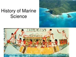
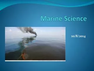
Marine Science Chapter 1 Ocean Exploration
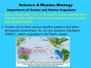
Oceanography– the science of recording and describing the ocean’s contents and processes. • There are four main branches of oceanography. • Biological oceanography– studies life in the ocean. (species, predation, symbiosis, behavior) • Chemical oceanography– studies the chemistry of seawater. (pH, density, pollutants, salinity) • Geological oceanography– studies the geology of the ocean. (underwater mountains, trenches, map making, plate tectonics, ) • Physical oceanography– studies the physics within the marine environment. (waves, tides, earthquakes, currents, temperatures)
The history of oceanography can be divided into four stages: • 1. Ancient Seafaring (5000 B.C. - 800 A.D.) • 2. The Middle Ages (800 - 1400) • 3. European Exploration (1400 - 1700) • 4. Modern Oceanography (1700 - present)
1) Ancient Seafaring • Three primary reasons for early civilization to interact with the ocean: • 1. To obtain food. • 2. To discover new lands. • 3. As a means of trade. • The earliest recorded sea voyage appears to be 3200 B.C. under the Egyptian Pharaoh Snefru.
Greeks • The Greeks used references on shore to navigate. This is called piloting. • As seafaring advanced they learned to use the sun, constellations, the North Star and sea conditions to navigate in the open ocean. • The Greeks knew the Earth was a sphere, not flat.
Greeks cont… • Pytheas (314 B.C.) predicted tides in the Atlantic based on the phases of the moon. • He could determine how far North or South one was from the North Star by measuring the angle between the horizon and the North Star. This was a significant improvement in navigation. • Eratosthenes (264-194 B.C.) is credited with two contributions: • 1. He calculated the Earth’s circumference (however, incorrectly). • 2. He invented the first latitude/longitude system.
Latitude/Longitude System • The purpose of the latitude and longitude mapping systemis to identify specific locations on the Earth’s surface. • Latitude Lines • Also called parallels • Run east-west • 0º parallel is also called the equator • Longitude Lines • Also called meridians • Run north-south • Prime Meridian is located on the longitude of the Royal Naval Observatory in Greenwich, England. 00 longitude • Further Accuracy • Degrees are subdivided into 60 minutes, minutes are subdivided into 60 seconds.
Hurricane Tracking Chart • 1) Plot the points • 2) Make a key and color code storm strength • Extratropical storm • Tropical storm • Hurricane 1 • Hurricane 2 • Hurricane 3 • Hurricane 4 • Hurricane 5
2) The Middle AgesAKA: The Dark Ages Viking Explorations and Discoveries • The Vikings were the only people with significant exploration taking place in Europe during the Dark Ages: • They discovered: • Iceland in 700 AD • Greenland in995 AD • Vineland (Nova Scotia) 1000 AD
Chinese Discoveries in the Middle Ages • Magnetic compass dating about 1000 A.D • Chinese ships from that period had central rudders and watertight compartments.
3) European Voyages of Discovery • The period of 1400-1700 is called the Renaissance. A new interest in long ocean expeditions and travel in the 15th century was motivated by economics, politics and religion. • Prince Henry the Navigator of Portugal established a center to study navigation. His expeditions were the 1st European to use a compass.
Europeans cont… The New World • Christopher Columbustook the first of his four voyages to find a route to Asia in 1492. He believed he’d found Asia when he landed on a Caribbean island. • Between 1454-1512, Amerigo Vespucci is credited as the first European to recognize that South America was a new continent. • In 1519, Portuguese explorer Ferdinand Magellan led the first expedition to circumnavigate the world. He had five ships and about 260 men. Only 34 men survived the journey, Magellan was not one of them. : (
Columbus Magellan
Film: The Great Age of Exploration • After watching the film, compose 2 paragraphs describing: • the benefits that came to countries by exploring the oceans. • the harm that came to countries from ocean exploration. • Disclaimer: This video repeatedly and falsely suggests that people of the Renaissance believed the Earth was flat.
1st Oceanography • 1770’s - The voyages of Captain James Cook receive credit as the first sea expeditions devoted to methodical, scientific oceanography. • He discovered Australia, New Zealand, many islands in the South Pacific, the Hawaiian Islands, charted the Great barrier Reef and took notes on human, animal and plant life. A major contribution to Cook’s voyages was the invention of the chronometer. In 1735, John Harrison invented a clock that runs accurately at sea. This made it possible to determine longitude accurately.
U.S. Exploring Expedition -1838 • Commanded Lt. Charles Wilkes aboard USS Vincinnes. • Proved the existence of Antarctica. • Returned with 19 volumes on new maps, descriptions, and illustrations. 1st time scientist were PAID to explore the oceans The Father of Physical Oceanography Matthew Maury • Between 1842-1855, Matthew Maury earned global acclaim for his study on ocean currents. • In 1855, he published The Physical Geography of the Sea, which is now considered the first textbook on modern oceanography.
Charles Wilkes Matthew Maury
The HMSChallengerExpedition (1872-1876) • Recognized as the first worldwide oceanographic expedition. Expedition devoted entirely to marine study. • Scottish professorSir Charles Wyville Thomsonand British naturalistSir John Murray. • Among its discoveries, the expedition: • Deepest soundings taken to date – 8,200 meters (26,900 feet) in the Marianas Trench. • Discovered marine organisms in the deepest parts of the ocean, contrary to popular belief at the time. • Compiled the first systematic plots of currents and ocean temperatures. • Cataloged and identified 4,717 new species.
Biography: John Harrison • JOHN HARRISON AND THE FINDING OF LONGITUDE • After reading, write a paragraph describing what longitude is, why it’s hard to find, and how the problem of finding it was solved.
Read “the longitude problem” pgs 18-20 so that you may answer the following questions. • Read pgs 18-20. You do not need to write the questions. Answer in complete sentences. 1) How did European explorers find latitude at sea? 2) How do you find longitude with a clock? 3) Why was it hard to find longitude at sea? 4) What happens to clocks at sea? 5) What did the British government do in 1714? 6) What were the requirements for the prize? 7) Who solved the problem? 8) What was his invention called? 9) Why didn’t he get paid after winning the prize? 10) When did he finally get paid? 11) What event allowed him to get paid? 12) Where are his 4 inventions located today? 13) Why is that site significant?
4) 20th Century Marine Science • The Industrial Revolution spearheaded the growth and expansion of marine sciences. This included: • Better ships made of iron with steam engines. • Improvements in the design and building of research equipment. • The advent of the submarine. • Global conflict helping to accelerate research in science and technology.
Three 20th Century Expeditions • The German MeteorExpedition (1925) • Mapped the Atlantic seafloor with echo-sounding technology. • The U.S. Atlantis Expedition – 1931 • The first ship specifically designed and built for ocean studies. • Confirmed the existence of the Mid-Atlantic Ridge and mapped it. • The H.M.S. Challenger IIExpedition – 1951 • Found the deepest known part of the ocean. At 10,838 meters (35,558 feet) deep, still the deepest known place in the world. • This spot, located in the Marianas Trench, was named Challenger Deep in honor of the first Challenger expedition.
Modern Oceanography • Newer devices for scientists • SONAR, which bounces sound waves off the ocean floor, is used to study depth and shape of the seafloor • Satellites in space help relay information and track location with GPS, make maps of the ocean floor, track ocean temperatures and currents • Remote submersibles go to deep ocean to explore without the need for humans
SONAR • Sound Navigation and Ranging provided a rapid method of looking through water to identify features in the water beneath a vessel and on the sea floor.
Alvin explored the Titanic/Hydrothermal Vents (HOV) The Trieste explored the Mariana’s Trench in 1960 (HOV) Hercules ROV
Oceanic Institutions • An early laboratory in Naples, Italy allowed study of the ocean without being in the ocean • 1912 - Scripps Institute was founded in La Jolla, CA • 1930 - Woods Hole Institute was founded on Cape Cod of Massachusetts • Our local marine lab is Grice Marine Laboratory Located at Ft. Johnson on James island. Operated by the College of Charleston.
Famous Modern Oceanographers • In 1943, Jacques Cousteauintroduced the first practical scuba. • Robert Ballard found the Titanic(1985) and other wrecks. Lee Spence discovered of the Civil War submarine H.L. Hunleyin 1970. James Cameron self-funded his expedition to the bottom of the Marianas Trench in 2012.