Download
1 / 21
210 likes | 214 Views
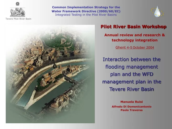
Tevere Pilot River Basin. Common Implementation Strategy for the Water Framework Directive (2000/60/EC) Integrated Testing in the Pilot River Basins. Pilot River Basin Workshop Annual review and research & technology integration. Ghent 4-5 October 2004.

E N D
Tevere Pilot River Basin Common Implementation Strategy for the Water Framework Directive (2000/60/EC) Integrated Testing in the Pilot River Basins Pilot River Basin Workshop Annual review and research & technology integration Ghent 4-5October 2004 Interaction between the flooding management plan and the WFD management plan in the Tevere River Basin Manuela Ruisi Alfredo Di Domenicantonio Paolo Traversa
Tevere Pilot River Basin Ecoregion 3 Basin surface area 17.374,996 km2 Population 4.344.197 inhabitants
2005 Adopted 2003 2005 Approved Adopted 2001 2005 2006 Art. 5 Managementplan Tevere River Basin PlanningandWFD 2000/60 Tevere River Basin Planning Water Balance plan (Tevere RB Authority) Water Protection Plan (Regional plan) Hydrogeological setting plan In consultation WFD 2000/60
Hydrogeological setting plan KNOWLEDGE SYSTEM Two activity lines: Geomorphological risk Efficiency of the mountain river basins in terms of hydrogeological defence Slope instability and gravitation movements Hydraulic risk Floodable areas in the flood plains
Hydrogeological setting plan SLOPE EFFICIENCY Analysis carried out on 181 sub-basins (average surface area 100 Km2): Rainfall analysis Geological map 1:25.000 Vegetation coverage map 1:10.000 Slope analysis by DEM Analysis method CN and USLE Identification of homogeneous areas Identification of evolution trends
Hydraulic hazard assessment procedure Hydrological analysis Rated flows calculated for different return times (50, 100, 200, 500 years) Topographic survey in sections spaced at 200-400 Hydraulic mono-dimensional simulation, in stationary motion (code HEC-RAS ver. 2.0) Comparison with the digital elevation model Calculation of the intersection between water surface and topography Delimitation of floodable areas
Hydraulic risk Air cover ALTM - CASI Survey area 1450 kmq 1800 river sections with first-order leveling Leveling (precision DEM h=30cm pass 2x2mt) Multispectrum images CASI
Hydraulic risk DTM with first-order leveling sections
Hydraulic risk Hydraulic simulation compared with the digital elevation model
Hydraulic risk Flooding areas
Hydraulic risk Land use
Hydraulic risk Town-planning
Hydraulic risk Risk areas (TR = 50)
Hydraulic risk ANTHROPIC DYNAMICS Loc. Ponte Valle Ceppi Urban development in floodable areas Linear infrastructures development in flood plains 1:25.000 IGM 1932 Imagine CASI 1998
Rome Hydraulic risk Floodable areas and hydraulic risk in Rome
Hydraulic risk “Ponte Milvio” bridge December 1937 Flood
Hydrogeological setting plan Plan objective Hydraulic risk reduction in alluvial plains through prevention in mountain areas Mountain areas Plan measures: To slow down the runoff in order to increase the infiltration Through • Reforestation • Hydraulic-forest works
Hydrogeological setting plan Plan objective Hydraulic risck reduction in alluvial plains through prevention in mountain areas Alluvial plain Plan measures: Protection of human life and settlements through • norms that regulate the use of the floodable zones • Defence works • Settlement displacement
Interaction Flooding mp - WFD mp Flooding Plan Measures Interaction with WFD Risk factors Increase of Effective Infiltration Aquifer recharge Reforestation mountain Alteration of the natural ecosystems Hydraulic-forest works Introduction of HMWB’s Defence works Removal of HMWB’s Settlement displacement Alluvial plain Introduction of Fluvial Parks Aquatic ecosystems and Wetlands
Thank you! www.abtevere.it manuela.ruisi@abtevere.it