Download
1 / 1

E N D
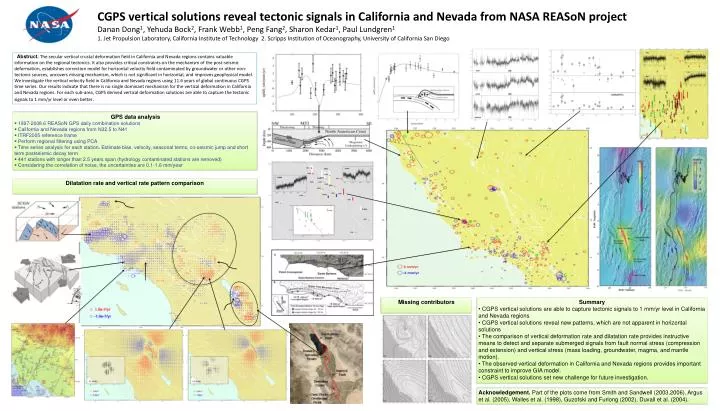
CGPS vertical solutions reveal tectonic signals in California and Nevada from NASA REASoN projectDanan Dong1, Yehuda Bock2, Frank Webb1, Peng Fang2, Sharon Kedar1, Paul Lundgren11. Jet Propulsion Laboratory, California Institute of Technology 2. Scripps Institution of Oceanography, University of California San Diego Abstruct. The secular vertical crustal deformation field in California and Nevada regions contains valuable information on the regional tectonics. It also provides critical constraints on the mechanism of the post-seismic deformation, establishes correction model for horizontal velocity field contaminated by groundwater or other non-tectonic sources, uncovers missing mechanism, which is not significant in horizontal, and improves geophysical model. We investigate the vertical velocity field in California and Nevada regions using 11.6 years of global continuous CGPS time series. Our results indicate that there is no single dominant mechanism for the vertical deformation in California and Nevada regions. For each sub-area, CGPS derived vertical deformation solutions are able to capture the tectonic signals to 1 mm/yr level or even better. • GPS data analysis • 1997-2008.6 REASoN GPS daily combination solutions • California and Nevada regions from N32.5 to N41 • ITRF2005 reference frame • Perform regional filtering using PCA • Time series analysis for each station. Estimate bias, velocity, seasonal terms, co-seismic jump and short term postseismic decay term • 441 stations with longer than 2.5 years span (hydrology contaminated stations are removed) • Considering the correlation of noise, the uncertainties are 0.1-1.6 mm/year Dilatation rate and vertical rate pattern comparison Missing contributors • Summary • CGPS vertical solutions are able to capture tectonic signals to 1 mm/yr level in California and Nevada regions • CGPS vertical solutions reveal new patterns, which are not apparent in horizontal solutions • The comparison of vertical deformation rate and dilatation rate provides instructive means to detect and separate submerged signals from fault normal stress (compression and extension) and vertical stress (mass loading, groundwater, magma, and mantle motion). • The observed vertical deformation in California and Nevada regions provides important constraint to improve GIA model. • CGPS vertical solutions set new challenge for future investigation. Acknowledgement. Part of the plots come from Smith and Sandwell (2003,2006), Argus et al. (2005), Walles et al. (1998), Guzofski and Furlong (2002), Duvall et al. (2004).