Download
1 / 1
20 likes | 148 Views
SHARP PP 2: Region of Western Macedonia. Existing Good Practices. Tools for Water Management Plans

E N D
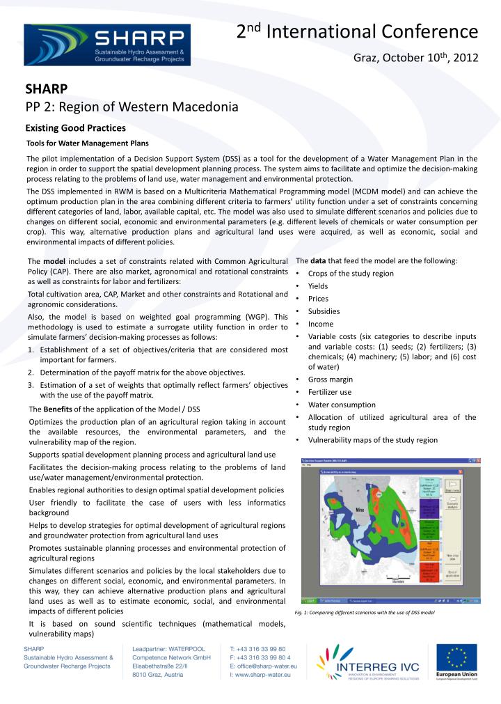
SHARP PP 2: Region of Western Macedonia Existing Good Practices Tools for Water Management Plans The pilot implementation of a Decision Support System (DSS) as a tool for the development of a Water Management Plan in the region in order to support the spatial development planning process. The system aims to facilitate and optimize the decision-making process relating to the problems of land use, water management and environmental protection. The DSS implemented in RWM is based on a Multicriteria Mathematical Programming model (MCDM model) and can achieve the optimum production plan in the area combining different criteria to farmers’ utility function under a set of constraints concerning different categories of land, labor, available capital, etc. The model was also used to simulate different scenarios and policies due to changes on different social, economic and environmental parameters (e.g. different levels of chemicals or water consumption per crop). This way, alternative production plans and agricultural land uses were acquired, as well as economic, social and environmental impacts of different policies. • The data that feed the model are the following: • Crops of the study region • Yields • Prices • Subsidies • Income • Variable costs (six categories to describe inputs and variable costs: (1) seeds; (2) fertilizers; (3) chemicals; (4) machinery; (5) labor; and (6) cost of water) • Gross margin • Fertilizer use • Water consumption • Allocation of utilized agricultural area of the study region • Vulnerability maps of the study region The model includes a set of constraints related with Common Agricultural Policy (CAP). There are also market, agronomical and rotational constraints as well as constraints for labor and fertilizers: Total cultivation area, CAP, Market and other constraints and Rotational and agronomic considerations. Also, the model is based on weighted goal programming (WGP). This methodology is used to estimate a surrogate utility function in order to simulate farmers’ decision-making processes as follows: Establishment of a set of objectives/criteria that are considered most important for farmers. Determination of the payoff matrix for the above objectives. Estimation of a set of weights that optimally reflect farmers’ objectives with the use of the payoff matrix. The Benefits of the application of the Model / DSS Optimizes the production plan of an agricultural region taking in account the available resources, the environmental parameters, and the vulnerability map of the region. Supports spatial development planning process and agricultural land use Facilitates the decision-making process relating to the problems of land use/water management/environmental protection. Enables regional authorities to design optimal spatial development policies User friendly to facilitate the case of users with less informatics background Helps to develop strategies for optimal development of agricultural regions and groundwater protection from agricultural land uses Promotes sustainable planning processes and environmental protection of agricultural regions Simulates different scenarios and policies by the local stakeholders due to changes on different social, economic, and environmental parameters. In this way, they can achieve alternative production plans and agricultural land uses as well as to estimate economic, social, and environmental impacts of different policies It is based on sound scientific techniques (mathematical models, vulnerability maps) Fig. 1: Comparing different scenarios with the use of DSS model