Download
1 / 29
300 likes | 830 Views
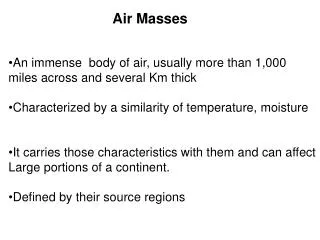
Air Masses and Midlatitude Cyclones. ATS 351 Lab 11 November 16, 2009. Air Masses of North America. Air mass: extremely large body of air whose properties of temperature and humidity are fairly similar in any horizontal direction at any given latitude Named for their region of origin

E N D
Air Masses and Midlatitude Cyclones ATS 351 Lab 11 November 16, 2009
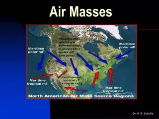
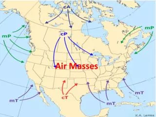
Air Masses of North America Air mass: extremely large body of air whose properties of temperature and humidity are fairly similar in any horizontal direction at any given latitude Named for their region of origin Continental Polar Continental Arctic Maritime Polar Maritime Tropical Continental Tropical
Cold Front Cold, dry stable polar air is replacing warm, moist, conditionally unstable subtropical air Steep vertical boundary due to surface friction slowing down the surface front Has strong vertical ascent along the surface front Strong upper level westerlies push ice crystals far ahead of the front, creating cirrus advance of the front. • Cold, dense air wedges under warm air, forcing the warm air upward, producing cumuliform clouds • Can cause strong convection, severe weather, and squall lines. • Air cools quickly behind the front
Air Masses of North America Continental Polar (cP) & Arctic (cA) Cold, dry, stable air in winter In summer, cP air mass usually brings relief from oppressive heat in central and eastern US Maritime Polar (mP) In winter, cold and dry continental air masses are carried over Pacific Ocean where moisture and warmth is added Air mass at Pacific Coast is cool, moist, and conditionally unstable East of Rockies - brings fair weather and cooler temperatures (moisture has been removed by mountains) East coast mP air mass: originates in N. Atlantic Storms may develop (heavy rain or snow, coastal flooding) Late winter, early spring
Air Masses of North America Maritime Tropical (mT) Subtropical east Pacific Ocean: very warm and moist by the time it reaches east coast Heavy precipitation Gulf of Mexico: warm, humid subtropical air Formation of dew, fog and low clouds along Gulf coast Could lead to record heat waves Continental Tropical (cT) Source is N Mexico and arid SW: only exist in summer Hot, dry and conditionally unstable at low levels Clear skies and hot weather (severe drought possible)
Air Masses and Fronts A front is a transition zone between two air masses of different densities Fronts extend both horizontally and vertically
Cold Front Rising motion causes decreased surface pressure ahead of the front On a surface pressure map, frontal location can be seen by “kinks” in the isobars, changes in wind direction from a southwesterly to a northwesterly wind, and decreases in temperature. Pressure is lowest at the surface front. On weather maps, cold fronts are indicated by blue lines with triangles pointing in the direction of frontal motion (towards warmer air)
Cold Front Before While After Winds S-SW Gusty, shifting W-NW Temperature Warm Sudden drop Steady drop Pressure Steady fall Min, then sharp rise Steady rise Clouds Increasing, Ci, Cs, Cb Cb Cu Precipitation Brief showers Heavy rains, severe weather Showers, then clearing Visibility Fair to poor Poor Good Dew Point High, remains steady Sharp drop Lowering
Warm Front Occurs at the leading edge of an advancing warm, moist, subtropical air mass from the Gulf replacing a retreating cold, maritime, polar air mass from the North Atlantic Slowly advances as cold air recedes; moves at about half the speed of an average cold front Speed may increase due to daytime mixing Speed may decrease due to nighttime radiational cooling Smaller vertical slope than cold front
Warm Front Warmer, less-dense air rides up and over the colder, more-dense surface air “Overrunning” Produces clouds and precipitation well in advance of the front
Warm Front Before While After Winds S-SE Variable S-SW Temperature Cool-cold Slowly warming Steady rise Warmer, then steady Pressure Falling Leveling off Slight rise, followed by fall Clouds (in order) Ci, Cs, As, Ns, St, fog (Cb in summer) Stratus-type Clearing with scattered Sc Precipitation Light-to-moderate Drizzle or none Usually none Visibility Poor Improving Fair Dew Point Steady rise Steady Rise, then steady
Stationary Front Essentially no movement Surface winds blow parallel to front, but in opposite directions on either side of it Separates two air masses Seen often along mountain ranges when cold air cannot make it over the mountain ridge
Hourly surface observations at Gage, Oklahoma showing the passage of a primary and secondary cold front (left) and at Bowling Green, Kentucky showing the passage of a warm front (right). Source: Wallace and Hobbs, 2006.
Occluded Fronts Cold fronts generally move faster than warm fronts Occlusion occurs when cold front catches up to and overtakes a warm front Occlusions can be warm or cold
Dry Lines Think of a dry line as a moisture boundary Separates warm, humid air from warm, dry air Drier air behind dry lines lifts the moist air ahead of it, triggering storms along and ahead of it Induces lifting along front Often produces severe thunderstorms in OK & TX Unique to southern great plains of US because of the Rocky mountains and the Gulf of Mexico
A guide to the symbols for weather fronts that may be found on a weather map: #1 cold front #2 warm front #3 stationary front #4 occluded front #5 surface trough #6 squall/shear line #7 dry line #8 tropical wave
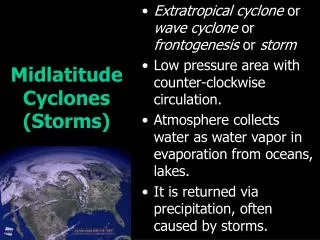
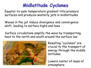
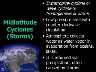
Midlatitude (Extratropical) Cyclone A cyclone (area of low pressure) in the middle latitudes (35°-70°) Important for global heat transport Help to redistribute energy between the tropics (equator) and the poles Often associated with significant weather events Described by the Polar Front Theory Form on boundaries between warm and cold air Cold Polar air meeting warm tropical air
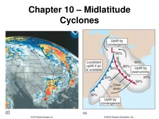
Features of a Midlatitude Cyclone Deep low pressure area with attached cold and warm fronts Often an occlusion forms, the triple point lending to the formation of severe weather Precipitation associated with the cold and warm fronts organizes in typical “comma cloud” structure
Polar Front Theory • Initially, there is a stationary front that acts as the boundary separating cold, continental polar air from warm, maritime tropical air • Winds blow parallel to this front on either side • Polar Fronts are discontinuous
Cyclogenesis Central Pressure • A wave forms on the front due to a shortwave disturbance • Frontal Wave • The front develops a "kink" where the wave is developing • Precipitation will begin to develop along the front • Overrunning and lifting
Strengthening • The cyclonic circulation around the low becomes more defined • The central pressure intensifies • The cold front and warm front have more organized motion • Cyclone usually pushed east or northeast by the winds aloft
Mature Cyclone • The cold front catches up with the warm front and an occlusion forms • The cyclone is at its strongest at this point • Severe weather often develops near the “triple point” - Intersection of cold, warm, and occluded fronts
Dissipation • The occlusion grows with time • Eventually, the occlusion is so great that the supply of warm, moist air into the low is cut off • Cold air on both sides • When this happens, the system starts to dissipate
Interaction with Upper Levels • Previous model for cyclone development only includes surface characteristics – but what happens higher up can determine what happens below • Divergence aloft can help to remove mass from a column, hence lowering the surface pressure even more
Interaction with Upper Levels • Downstream of an upper level trough, the air tends to diverge • If a surface low is located slightly downstream of an upper level trough, the divergence will be located above the low and help to intensify it
Mid-latitude Cyclones: The Upper Level Life Cycle • A 500 mb trough develops westward of a surface stationary front • As the 500 mb trough deepens, the associated upper level divergence strengthens, helping to intensify the surface low • Stronger winds aloft force the upper level trough to move eastward faster, and eventually it becomes located above the surface low • When the surface and upper level low are “stacked”, convergence at both levels starts to “fill” the low pressure area, weakening the cyclone
Closed Low • A closed low is an upper level area of low pressure that is completely encircled by at least one isobar • This may be partially or completely detached from the main flow • Often results from occlusion of surface cyclone • These can persist for several days without moving and produce several days worth of precipitation over the area where they park • Called cut-off low when completely separated from main flow at upper levels