Download
1 / 6
60 likes | 223 Views
Revelle cloud and boundary layer Doppler remote sensing Simon de Szoeke, Alan Brewer, Chris Fairall . image structures: rain shafts, cold pools, gusts Separate rain fall velocity from air velocity turbulence retrieval – microphysical retrieval Diurnal and MJO composite statistics

E N D
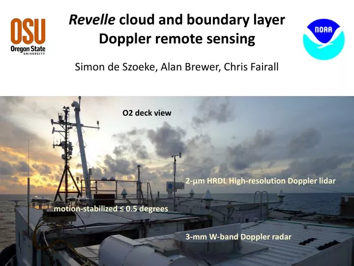
Revelle cloud and boundary layerDoppler remote sensingSimon de Szoeke, Alan Brewer, Chris Fairall • image structures: rain shafts, cold pools, gusts • Separate rain fall velocity from air velocity • turbulence retrieval – microphysical retrieval • Diurnal and MJO composite statistics • rain frequency and type • cloud and subcloud turbulence • shallow cumulus cloud top heights O2 deck view 2-μm HRDL High-resolution Doppler lidar motion-stabilized ≤ 0.5 degrees 3-mm W-band Doppler radar
W-band cloud radar HRDL lidar scanning Continuously points at zenith 0 Shallow PPI High PPI Shallow RHI 10 • Both instruments sample features in the atmosphere as they pass over. • Mean winds, turbulence, and spatially/temporally evolving wind field • Motion stabilized Doppler radial/vertical velocities. Zenith minutes 20 6 km range
Revelle cloud and boundary layerDoppler remote sensingSimon de Szoeke, Alan Brewer, Chris Fairall • HRDL and W-band cloud radar measure rain and clear air velocities: • coherent fronts and flows • turbulence • Separate rain fall velocity from air velocity • Pinsky et al. (2010) air velocity retrieval • cloud and subcloud turbulence • Combine with areal precipitation statistics from TOGA C-band radar. • composite over MJO convective & suppressed events NOAA W-band cloud radar October 19 hour (UTC)
Stratiform precipitationhas steady fall velocity. • makes air velocity visible to radar. • DYNAMO has ~100 hours of stratiform rain. Doppler velocity anomaly (m/s) Doppler width (m/s) Kelvin-Helmholtz billows
imaging fronts with radar and lidar radar vertical lidar RHI A B lidar PPI B A B A radar vertical velocity Processing shows Nyquist-unwrapping and subtracting stratiform rain fall speed. lidar horizontal velocities Spatial sampling by lidar RHI and PPI scans show the front passing over the ship in radial Doppler velocity and backscatterretrievals. see Alan Brewer’s talk and poster
Doppler velocity anomaly (m/s) use to diagnose turbulence vertical velocity turbulence spectra height (km) f–5/3 S2(m2 s–1)