Download

1 / 3
30 likes | 184 Views
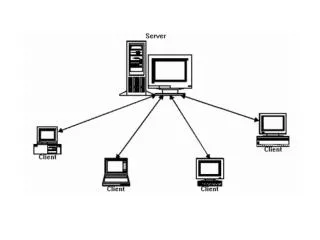
Build your own application. Encode into your product. Provide model output as WMS images. Client 1. ADCIRC Model outputs (surge, wind, depth, wave peak etc.). Google Maps. Client n. ASGS. CERA post-processing using OGC standards (WMS, WFS). ADCIRC/SWAN model runs

E N D
Build your own application Encode into your product Provide model output as WMS images Client 1 ADCIRC Model outputs (surge, wind, depth, wave peak etc.) Google Maps Client n
ASGS CERA post-processing using OGC standards (WMS, WFS) ADCIRC/SWAN model runs high performance computing resources email notification NGCHC data server or OPeNDAP server email notification GIS files for emergency managers (shape files) - in work Shared Tile Cache raster images (e.g. for mobile applications) Share and distribute output data files CERA web application Direct data access by clients via WMS/WFS
CERA automated real-time post-processing workflow > 50 individual scripts written in C++, Perl and Python Most are tailored to ASGS/CERA needs Extract script with general usability and provide them as NGCHC tools NHC text advisories to ATCF format ADCIRC ASCII to NetCDF script