Download
1 / 22
220 likes | 352 Views
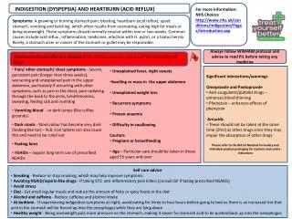
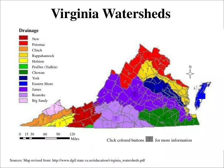
Virginia Watersheds. Drainage. New. Potomac. Clinch. Rappahannock. Holston. PeeDee (Yadkin). N. Chowan. York. Eastern Shore. James. Roanoke. Big Sandy. 0. 15. 30. 60. 90. 120. Miles. Click colored buttons for more information.

E N D
Virginia Watersheds Drainage New Potomac Clinch Rappahannock Holston PeeDee (Yadkin) N Chowan York Eastern Shore James Roanoke Big Sandy 0 15 30 60 90 120 Miles Click colored buttons for more information Sources: Map revised from: http://www.dgif.state.va.us/education/virginia_watersheds.pdf
New River Watershed Location: Southwestern Virginia Flow: Northern North Carolina to Western West Virginia; into Gauley River which forms the Kanawha River a tributary to the Ohio River Topography: rugged; with upper reaches of its tributaries being extremely steep Composition: approximately 59% forested, 35% cropland and pasture, and 3% urban. Information Source: http://www.sosva.com/new_river.htm Map revised from: http://www.dgif.state.va.us/education/va_watersheds_bw.pdf
New River Watershed Location: Southwestern Virginia Flow: Northern North Carolina to Western West Virginia; into Gauley River which forms the Kanawha River a tributary to the Ohio River Topography: rugged; with upper reaches of its tributaries being extremely steep Composition: approximately 59% forested, 35% cropland and pasture, and 3% urban. Information Source: http://www.sosva.com/new_river.htm Map revised from: http://www.dgif.state.va.us/education/va_watersheds_bw.pdf
Potomac Watershed Location: Northern Virginia Flow: form Augusta County, VA, flows northeasterly direction approximately 100 miles to the West Virginia Topography: rolling hills and valleys bordered by the Appalachian Mountains to the west and the Blue Ridge Mountains to the east. Composition: approximately 45% forested, 39% farmland and pasture, and 16% urban. Information Source: http://www.sosva.com/shenandoah.htm Map revised from: http://www.dgif.state.va.us/education/va_watersheds_bw.pdf
Potomac Watershed Location: Northern Virginia Flow: form Augusta County, VA, flows northeasterly direction approximately 100 miles to the West Virginia Topography: rolling hills and valleys bordered by the Appalachian Mountains to the west and the Blue Ridge Mountains to the east. Composition: approximately 45% forested, 39% farmland and pasture, and 16% urban. Information Source: http://www.sosva.com/shenandoah.htm Map revised from: http://www.dgif.state.va.us/education/va_watersheds_bw.pdf
Clinch Watershed Location: Southwestern Virginia Flow: southwest to the Tennessee River in Tennessee and eventually empty into the Gulf of Mexico via the Ohio and Mississippi Rivers Topography: This Basin spans three physiographic provinces:The Cumberland Plateau is rugged, with mountainous terrain and steep valleys. The Valley and Ridge Province consists of parallel valleys and ridges running northeast to southwest. The Blue Ridge Province is more plateau-like, with no single, prominent ridge. Composition: approximately 48% forested and 39.7% cropland and pasture Information Source: http://www.sosva.com/clinch.htm Map revised from: http://www.dgif.state.va.us/education/va_watersheds_bw.pdf
Clinch Watershed Location: Southwestern Virginia Flow: southwest to the Tennessee River in Tennessee and eventually empty into the Gulf of Mexico via the Ohio and Mississippi Rivers Topography: This Basin spans three physiographic provinces:The Cumberland Plateau is rugged, with mountainous terrain and steep valleys. The Valley and Ridge Province consists of parallel valleys and ridges running northeast to southwest. The Blue Ridge Province is more plateau-like, with no single, prominent ridge. Composition: approximately 48% forested and 39.7% cropland and pasture Information Source: http://www.sosva.com/clinch.htm Map revised from: http://www.dgif.state.va.us/education/va_watersheds_bw.pdf
Rappahannock Watershed Location: Northeastern Virginia Flow: from the Blue Ridge Mountains to the Chesapeake Bay Topography: steep to flat Composition: approximately 51% forested, 36% cropland and pasture, and 6% urban Information Source: http://www.sosva.com/rappahannock.htm Map revised from: http://www.dgif.state.va.us/education/va_watersheds_bw.pdf
Rappahannock Watershed Location: Northeastern Virginia Flow: from the Blue Ridge Mountains to the Chesapeake Bay Topography: steep to flat Composition: approximately 51% forested, 36% cropland and pasture, and 6% urban Information Source: http://www.sosva.com/rappahannock.htm Map revised from: http://www.dgif.state.va.us/education/va_watersheds_bw.pdf
Holston Watershed Location: Southwestern Virginia Flow: southwest to the Tennessee River in Tennessee and eventually empty into the Gulf of Mexico via the Ohio and Mississippi Rivers Topography: This Basin spans three physiographic provinces: The Cumberland Plateau is rugged, with mountainous terrain and steep valleys. The Valley and Ridge Province consists of parallel valleys and ridges running northeast to southwest. The Blue Ridge Province is more plateau-like, with no single, prominent ridge. Composition: approximately 48% forested and 39.7% cropland and pasture Information Source: http://www.sosva.com/holston.htm Map revised from: http://www.dgif.state.va.us/education/va_watersheds_bw.pdf
Holston Watershed Location: Southwestern Virginia Flow: southwest to the Tennessee River in Tennessee and eventually empty into the Gulf of Mexico via the Ohio and Mississippi Rivers Topography: This Basin spans three physiographic provinces: The Cumberland Plateau is rugged, with mountainous terrain and steep valleys. The Valley and Ridge Province consists of parallel valleys and ridges running northeast to southwest. The Blue Ridge Province is more plateau-like, with no single, prominent ridge. Composition: approximately 48% forested and 39.7% cropland and pasture Information Source: http://www.sosva.com/holston.htm Map revised from: http://www.dgif.state.va.us/education/va_watersheds_bw.pdf
Chowan Watershed Location: Southeastern Virginia Flow: through the Piedmont and Coastal Plain Physiographic Provinces Topography: The Piedmont portion of the Basin is characterized by rolling hills, steeper slopes, and somewhat more pronounced stream valleys. The Coastal Plain portion is nearly flat, with a descending series of terraces. The Basin includes the Dismal Swamp. Composition: approximately 64% forested, 28% cropland and pasture, and 6% urban Information Source: http://www.sosva.com/chowan.htm Map revised from: http://www.dgif.state.va.us/education/va_watersheds_bw.pdf
Chowan Watershed Location: Southeastern Virginia Flow: through the Piedmont and Coastal Plain Physiographic Provinces Topography: The Piedmont portion of the Basin is characterized by rolling hills, steeper slopes, and somewhat more pronounced stream valleys. The Coastal Plain portion is nearly flat, with a descending series of terraces. The Basin includes the Dismal Swamp. Composition: approximately 64% forested, 28% cropland and pasture, and 6% urban Information Source: http://www.sosva.com/chowan.htm Map revised from: http://www.dgif.state.va.us/education/va_watersheds_bw.pdf
York Watershed Location: Central and Eastern Virginia Flow: headwaters begin in Orange and Louisa counties and flow in a southeasterly direction for approximately 220 miles to its mouth at the Chesapeake Bay Topography: slightly rolling hills in the headwaters to gently sloping hills and flat farmland near its mouth Composition: approximately 64% forested, 20% farmland and pasture, and 10% urban Information Source: http://www.sosva.com/york.htm Map revised from: http://www.dgif.state.va.us/education/va_watersheds_bw.pdf
York Watershed Location: Central and Eastern Virginia Flow: headwaters begin in Orange and Louisa counties and flow in a southeasterly direction for approximately 220 miles to its mouth at the Chesapeake Bay Topography: slightly rolling hills in the headwaters to gently sloping hills and flat farmland near its mouth Composition: approximately 64% forested, 20% farmland and pasture, and 10% urban Information Source: http://www.sosva.com/york.htm Map revised from: http://www.dgif.state.va.us/education/va_watersheds_bw.pdf
Eastern Shore Watershed Location: Eastern Virginia Flow (Drainage): Tributaries in the Basin that drain to the Chesapeake Bay include Great Wicomico, Piankatank, Fleets Bay, Mobjack Bay, Poqouson, Back River, and Lynnhaven. Tributaries on the Eastern Shore that drain to the Chesapeake Bay include Pocomoke, Ononcock, Pungateague, Occohannock, and Nassawadox. Tributaries that drain directly into the Atlantic Ocean include Machipongo, Cat Point Creek, Assawoman Creek, Parker Creek, Folly Creek, and Finney Creek. Topography: marshland Composition: approximately 30% forested, 21.6% cropland and pasture, and 24% urban Sorry, no animation available Information Source: http://www.sosva.com/chesapeake.htm Map revised from: http://www.dgif.state.va.us/education/va_watersheds_bw.pdf
James River Watershed Location: Central Virginia Flow: begins in the Alleghany Mountains and flows in a southeasterly direction for 228 miles to the Fall Line at Richmond and another 111 miles to Hampton Roads where it enters the Chesapeake Bay Topography: Virginia's largest river basin and is made up of the Upper, Piedmont, and Lower James River sub-basins Composition: approximately 65% forested, 19% cropland and pasture, and 12% urban Information Source: http://www.sosva.com/piedmont_james.htm Map revised from: http://www.dgif.state.va.us/education/va_watersheds_bw.pdf
James River Watershed Location: Central Virginia Flow: begins in the Alleghany Mountains and flows in a southeasterly direction for 228 miles to the Fall Line at Richmond and another 111 miles to Hampton Roads where it enters the Chesapeake Bay Topography: Virginia's largest river basin and is made up of the Upper, Piedmont, and Lower James River sub-basins Composition: approximately 65% forested, 19% cropland and pasture, and 12% urban Information Source: http://www.sosva.com/piedmont_james.htm Map revised from: http://www.dgif.state.va.us/education/va_watersheds_bw.pdf
Roanoke Watershed Location: Southern Virginia Flow: southeast through North Carolina to the Albemarle Sound Topography: steep slopes and valleys in the Valley and Ridge Province to gently sloping terrain in the Piedmont Province Composition: approximately 62% forested, 25% cropland and pasture, and 10% urban Information Source: http://www.sosva.com/roanoke_river.htm Map revised from: http://www.dgif.state.va.us/education/va_watersheds_bw.pdf
Roanoke Watershed Location: Southern Virginia Flow: southeast through North Carolina to the Albemarle Sound Topography: steep slopes and valleys in the Valley and Ridge Province to gently sloping terrain in the Piedmont Province Composition: approximately 62% forested, 25% cropland and pasture, and 10% urban Information Source: http://www.sosva.com/roanoke_river.htm Map revised from: http://www.dgif.state.va.us/education/va_watersheds_bw.pdf
Big Sandy Watershed Location: Southwestern Virginia Flow: northward into Kentucky and eventually empty into the Gulf of Mexico via the Ohio and Mississippi Rivers Topography: rugged, with mountainous terrain and steep valleys Composition: approximately 62% forested, 25% cropland and pasture Information Source: http://www.sosva.com/bigsandy.htm Map revised from: http://www.dgif.state.va.us/education/va_watersheds_bw.pdf
Big Sandy Watershed Location: Southwestern Virginia Flow: northward into Kentucky and eventually empty into the Gulf of Mexico via the Ohio and Mississippi Rivers Topography: rugged, with mountainous terrain and steep valleys Composition: approximately 62% forested, 25% cropland and pasture Information Source: http://www.sosva.com/bigsandy.htm Map revised from: http://www.dgif.state.va.us/education/va_watersheds_bw.pdf