Download
1 / 19
190 likes | 302 Views
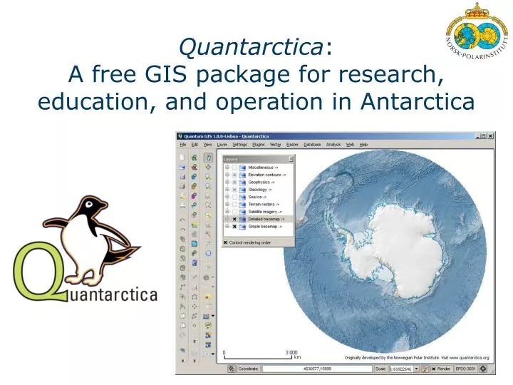
Quantarctica : A free GIS package for research, education, and operation in Antarctica. Quantarctica. Works with free software Quantum GIS. Includes a range of geographical data . Requires no internet access for the daily use, i.e. suitable for operation in Antarctica.

E N D
Quantarctica:A free GIS package for research, education, and operation in Antarctica
Quantarctica • Works with free software Quantum GIS. • Includes a range of geographical data. • Requires no internet access for the daily use, i.e. suitable for operation in Antarctica. • Is able to plot GPS-provided current positions together with GIS layers. Nice for research/operation in Antarcticaas well as education.
What’s really unique? • Uniform map projection for all datasets • Optimized file size for satellite images • Sophisticated cartography • Capabilities to add your own data layers on Quantarctica and make your own GIS package.
A ”ready-to-go” package This morning, to make a sandwich,you started with bread, not flour. Whydo you start with flourto do your job?
Developer team at NPI Anders Skoglund Angelavon Deschwanden KennyMatsuoka - Previous versions were tested more than 2 years. - Now Quantarctica version 1.0 is publicly released and will keep growing as a community effort.
Quantum GIS • Open source (GNU) • First release in 2002. • Regular updates. • Numerous plugins. • Activecommunitysupport. • http://www.qgis.org/
Screenshot: detailed basemap You have simple continet-wide and informaiton-rich close-up views.
Import of high-res satellite images High-resolution satellite imagenary can be imported with few clicks.
Attribute table A right click gives an easy access to attributes of each facility (layer)
Print composer High-quality figures for publications can be easily made
Data currently available on QA (1) Glaciology Ice flowvelocity Bed elevation Ice thickness Grounding line Subglacial lakes various more
Error layers Ice-flowspeed Ice thickness More transparent cells have more confident estimates
Data currently available on QA (2) Glaciology Ice flow velocity Bed elevation Ice thickness Grounding line Subglacial lakes Surface elevation Geothermal flux Surface mass balance • Surface temperature various more
Data currently available on QA (3) Geophysics Magnetic anomalies Gravity anomalies Geoid heights
Data currently available on QA (4) Sea Ice Monthly sea ice extent
Plugins: an example Profile plugin extracts digital values (e.g. elevation) from raster data
Metadata and references Eachlayer has a descriptionincludingreferences Abstract: The surfacetemperatureestimates in °C arederived from AVHRR infrared data. Annualmeantemperatures from 1982–2004 wereaveraged to providethesurface air temperaturefield. Originators: http://doi.pangaea.de/10.1594/PANGAEA.734145 Publisher: Le Brocq, A. M., Payne, A. J., and Vieli, A.: An improvedAntarcticdataset for highresolutionnumericalicesheetmodels (ALBMAP v1), EarthSyst. Sci. Data, 2, 247-260, doi:10.5194/essd-2-247-2010, 2010. Publication date: 2010 Data location: \Quantarctica\Scientific\Glaciology\ALBMAP\ALBMAP_Temp.tif References:Comiso, J. C.: Variability and trends in Antarcticsurfacetemperatures from in situ and satelliteinfraredmeasurements, J. Climate, 13(10), 1674–1696, 2000.
Supporting community effort • It’s a community effort. • Layer contributions are expected. • Data layers particularly for oceanography, geology, meteology, biology, …. • Model-output layers for any disciplines. • ML annoucning updates (please register yourself at the web site below). Download and contribute! www.quantarctica.org
Thanks! Contribute? Contact us at: quantarcitca@npolar.no