Download

1 / 8
80 likes | 149 Views
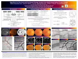
High-definition Images Reveal Changes on Many Scales. National Aeronautics and Space Administration. NASA radar reveals local surprises. . . . . .and troubling fault motions 60 km north Precise images are adding realism to crustal models and forecasts

E N D
High-definition Images Reveal Changes on Many Scales National Aeronautics and Space Administration • NASA radar reveals local surprises. . . . . .and troubling fault motions 60 km north • Precise images are adding realism to crustal models and forecasts • UAVSAR blanketing California danger zones with change-detection images 1
NASA Radar (UAVSAR) Imaging Quake Borderland and Beyond National Aeronautics and Space Administration Early image samples from UAVSAR Project, Scott Hensley Oval indicates a region of triggered fault slip 2
Quake Triggers Responses on Key Faults National Aeronautics and Space Administration >Mw 2.0 Earthquakes (Apr-Dec 2010, orange dots) from the ANSS Worldwide Earthquake Catalog, Advanced National Seismic System Fault traces from Southern California Earthquake Center, Uniform California Earthquake Rupture Forecast (UCERF-2), Edward H. Field and coworkers. • Elsinore fault extends into Los Angeles • San Jacinto fault reaches to San Bernardino • Full-length ruptures must be considered: damaging earthquakes 3
UAVSAR Images Slip 60 Km North of Earthquake National Aeronautics and Space Administration • Changes from 24 April 2009 to 13 April 2010 • Chiefly due to earthquake in Baja (El Mayor-Cucapah) • “Creases” resemble fault slip 4
Imaged Slip Matches San Jacinto Fault Lines National Aeronautics and Space Administration Scale: 20 km Fault traces (red) from USGS Earthquake Hazards Program • Left trace: Borrego Mountain Earthquake (1968, Mw 6.5); Right trace, top: Elmore Ranch Earthquake (1987, Mw 6.2); Right trace, bottom: Superstition Hills Earthquake (1987, Mw 6.6) • Fresh slip on these faults verified in the field (Treiman) • Signals stress transfer north into San Jacinto fault system; ripe for a damaging earthquake? 5
Fault Precision Drives Hazard Simulations -- Virtual California National Aeronautics and Space Administration Virtual California faults, John Rundle and coworkers (UC Davis) • Part of NASA QuakeSim project, which develops earthquake simulations and resources. • Computer simulation: A 100,000 year virtual history of earthquakes, movies • Addresses important hazard questions: how likely is a San Jacinto fault full/partial rupture? • Relies on real fault information over wide areas, as radar imaging provides. • Produces scores of large Baja virtual earthquakes (at right): • -- easy to find ones followed by damaging earthquakes to the north (3-30 years later). 6
Regular UAVSAR Imaging Blankets California’s Danger Zones National Aeronautics and Space Administration • Flight plans cover major faults, • including Elsinore, San Jacinto, • San Andreas every six months • detecting any changes. • Earthquakes receive extra coverage • Standing out instantly: • quakes, creeping faults. • Within a few years: • the slow motions of major faults. 7
Radar Imaging Enables Fresh Ways of Doing Earthquake Science National Aeronautics and Space Administration • Unprecedented complexity revealed in rupture pattern in Baja. • Geologists enabled to rapidly map emerging fault networks. • Satellites cover the globe, UAVSAR blankets California danger zones, LiDAR provides stunning detail. Coming: DESDynI mission. • Is key to improving hazard forecasts, tracking slow fault motions. • Images signs of stress transfer threatening cities to north. 8