Download
1 / 1
10 likes | 201 Views
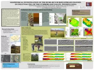
GEOPHYSICAL INVESTIGATION OF THE BURD-RUN BURIED STREAM CHANNEL IN COLLUVIAL FILL OF THE CUMBERLAND VALLEY, PENNSYLVANIA. Neal P Kerrigan (nk9027@ship.edu), Sean R Cornell, Joseph T Zume , and Dana M Heston Department of Geography and Earth Science, Shippensburg University

E N D
GEOPHYSICAL INVESTIGATION OF THE BURD-RUN BURIED STREAM CHANNEL IN COLLUVIAL FILL OF THE CUMBERLAND VALLEY, PENNSYLVANIA Neal P Kerrigan (nk9027@ship.edu), Sean R Cornell, Joseph T Zume, and Dana M Heston Department of Geography and Earth Science, Shippensburg University 1871 Old Main Drive Shippensburg, PA 17257 Preliminary Site Assessment and Ground Truthing Abstract: This study used a multi-method geophysical approach, including electrical resistivity, electromagnetic induction, and ground penetrating radar, to image a known buried stream channel in the Burn Run watershed near Shippensburg University campus in Pennsylvania. The buried stream channel was filled-in during a stream restoration project in 2001. Prior to the in-filling, the stream channel was mapped and characterized. Sandy silts mixed with a variety of organics, minor cobble materials from the restored stream channel, and topsoil were used to fill the channel and build it up to grade for the development of a recreational field. This study was performed on four, 50-meter long transects oriented perpendicular to the long-axis of the buried stream channel. Before embarking on the geophysical investigation, the study site was mapped with a total station to establish surface topography, to be used for terrain correction in the geophysical analysis. Soil auger samples were also taken for ground-truthing geophysical anomalies. Preliminary analyses of the geophysical investigation yielded anomalies that are consistent with the known dimensions of the buried stream channel. • References • GoogleEarth. 2012. Date accessed: 2/22/2012 • Shippensburg University. 2012. How to get to Shippensburg. Date accessed: 3/16/2012. http://www.ship.edu/Visit/Directions/ • WoltemadeCJ, Wood A. 2002 Comprehensive Riparian Restoration Along Burd Run. Land and Water. 46(2):27-32 Topography: Topography over the survey areas portrays elevation changes of less than a meter. Elevation rises as one goes upstream. Due to the infilling of the channel, there is a mound above it that constitutes the most variation of topography observed on the elevation data collected with the total station was downloaded into ArcGIS where a map was created . Soil Survey: Seven soil samples were collected in total and analyzed. There were significant textural and moisture -contents differences in the soils. Soil Auguring penetrated approximately 40cm outside the channel and a 1m within the channel before hitting cobbles. Predominantly Clay Saturated Ground Less Saturated Ground Metallic Interference Clay with sand Surfer Predominantly Sand and Cobble Data Collection • Research Questions • Can geophysical techniques be used to detect the buried stream channel? • Are results from one geophysical method complimentary to the others? Electromagnetic Induction (EM): An EM survey using an EMP400 Profiler was conducted with an 8000Hz antenna Data was collected on a 2omx40m grid with a spacing of 2m. The conductivity readings were recorded in a field notebook and transferred into a Microsoft Excel spreadsheet. This data was turned into maps in ArcGIS10 and Surfer 10 software. The images are displayed in the figures to the right. The survey performed on a day after a rain event showed relatively homogeneous conductivity across the entire study. The exception to this was when the profiler ran over a manhole cover making data in the northwest corner of the study area unreliable. A second survey was performed on a day when the ground was considerably less saturated. The data showed a distinct conductivity anomaly over the buried channel. Metallic Interference ArcGIS Methods Three geophysical methods were performed on transects running perpendicular to the buried stream channel. Each transect was 50m long across the buried channel Results of the geophysical survey were crosschecked against soil samples taken along the same profiles. To place the location of the buried channel, two Google Earth images from 1994 and 2008 , showing the original (buried) and modified channels were used. The topography along each transect was also determined using a total station. Soil sampling was performed with a 1.5m bucket auger and analyzed to compare compositional differences between the fill-soil within the channel from that outside the channel. EMP400 Transect 3 Raw Data Processed Interpreted East East Ground Penetrating Radar (GPR): The GPR survey was performed using the 100 and 250MHz antennae along the same profiles as the ER and EM. The GPR data were viewed and processed in GroundVision2 000 and Rad Explorer software respectively. The recorded anomalies are presented to the right. West West West East Separate Anomaly Pipe Channel and Fill 100MHz 2012 Pipe Channel and Fill Separate Anomaly Channel width: ~10.5m Channel depth: ~ 1.5m 250MHz Processed Data Interpreted Data East West West East 1994 Electrical Resistivity (ER): The Geometric OhmMapper was used for the ER survey. The survey lines were 10m apart. The data was processed using MagMap2000 software and Res2DInverse software. Distinct resistivity anomalies are shown in the figures to the right. 2008 Channel Fill extent Fill extent Possible Saturated Clay Mantle OhmMapper Interpolation above gray dotted line. Not adjusted for topographical variation Dipole length : 2.5m Rope length: 1m • Acknowledgements • Shippensburg University, Department of Geography and Earth Sciences • Shippensburg University Division of Graduate Research • National Science Foundation • Conclusions • All three geophysical methods successfully detected the buried stream channel being approximately 10.5m wide and 2m deep as the fill material and parent material have varying composition and stratigraphy. • Each method contributes an aspect of the channel including identifying the water table (ER), proximity to a sewage pipe (GPR), and alignment with the exposed stream channel (EM). • Geophysics is a useful tool for environmental monitoring of shallow subsurface processes.