Download
1 / 38
380 likes | 547 Views
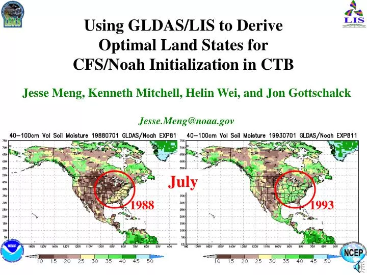
Using GLDAS/LIS to Derive Optimal Land States for CFS/Noah Initialization in CTB. Jesse Meng, Kenneth Mitchell, Helin Wei, and Jon Gottschalck Jesse.Meng@noaa.gov. July. 1988. 1993. When do we need initialization?. Cold start a new simulation e.g., flood, drought

E N D
Using GLDAS/LIS to DeriveOptimal Land States forCFS/Noah Initialization in CTB Jesse Meng, Kenneth Mitchell, Helin Wei, and Jon Gottschalck Jesse.Meng@noaa.gov July 1988 1993
When do we need initialization? • Cold start a new simulatione.g., flood, drought • Model upgradee.g., physics, parameters, resolution • Model bias constrain • coupled – e.g., 4DDA, Reanalysis • uncoupled – e.g., GLDAS
Current CFS • T62 • 25-year hindcast • OSU LSM • Initial land states from Global Reanalysis 2 (GR2)- T62, 25-year reanalysis, OSU LSM • Anticipated in Next-Generation CFS • T126 • 25-year hindcast • Noah LSM • Initial land states from Global Reanalysis 3 (GR3)- T126, 25-year reanalysis, Noah LSM** ** Not yet available • While awaiting coupled GR3:UncoupledT126GLDAS with Noah LSM will provide 25-year initial land states forT126 CFS/Noah CFS
GR2 vs GLDAS • Horizontal Resolution • T62 (194 x 94) T126 (384 x 190) • Land component vertical resolution • 2 soil layers (10, 190 cm) 4 soil layers (10, 30, 60, 100 cm) • OSU LSM Noah LSM • Addition of frozen soil physics • Improved physics: snowpack evaporation ground heat flux infiltration & runoff • Precipitation forcing: • Both use CPC CMAP precipitation, but different methodology • Other non-precip surface forcing: • Both from GR2
NCEP Reanalysis2 2-Layer Soil Moisture00Z 01 Jan 1979 T62 0-10 cm 10-200 cm GLDAS also needs a cold start initial condition
0-10 cm 10-40 cm 100-200 cm 40-100 cm GLDAS 4-Layer Soil Moisture(mapped from GR2 for 01 Jan 1979 cold start) T126
0-10 cm 10-40 cm 100-200 cm 40-100 cm GLDAS 4-Layer Soil Moisture(after 5-year spinup with repeated 1979 GR2 forcing) T126
NCEP Reanalysis2 vs GLDAS spinup GR2/OSU January GLDAS/Noah
NCEP Reanalysis2 vs GLDAS spinup GR2/OSU January GLDAS/Noah
NCEP Reanalysis2 vs GLDAS spinup GR2/OSU July GLDAS/Noah
NW NC NE SW SC SE CONUS SubRegions
Vol. Soil Moisture 10-40cmFive annual cycles spinup of 1979 Deeper soil layers require longer spinup
Vol. Soil Moisture 40-100cmFive annual cycles spinup of 1979 Deeper soil layers require longer spinup
Vol. Soil Moisture 100-200cmFive annual cycles spinup of 1979 Has bottom soil layer in the West fully spunup?
Optimal Precipitation Forcing • Purpose: Create a 6-hourly global land-only precipitation dataset primarily based on rain gauge observations • Datasets: CMAP Spatial: 2.5° x 2.5°, Temporal: Pentad • GTS land only Spatial: 0.5° x 0.5°, Temporal: Daily • GR2 Spatial: 2.5° x 2.5°, Temporal: 6-hourly • Approach: • (1) Disaggregate CMAP pentad precipitation to daily 0.5° x 0.5° resolution • using the GTS dataset • (2) Disaggregate dataset created in (1) to 6-hourly 0.5° x 0.5° resolution using GR2 dataset • For both (1) and (2) above: • (a) Higher temporal resolution data is summed for the lower temporal resolution data period • (b) Weights are calculated for each period of the higher temporal resolution data • (c) These weights are applied to the lower temporal resolution data • (d) Additional rules: • If precipitation for the lower temporal resolution data > 0 but the precipitation of the higher temporal resolution data is = 0, a search is conducted in a 5° x 5° area starting from the inside out to find a suitable weight. • If precipitation for the lower temporal resolution data = 0, final precipitation is = 0 • References: Xie P., and P. A. Arkin, 1996: Global precipitation: a 17-year monthly analysis based on gauge observations, satellite estimates, and numerical model outputs. Bull. Amer. Meteor. Soc., 78, 2539-2558.
NW NC NE SW SC SE CONUS SubRegions
Daily Precipitation [mm]1979 GR2 CMAP
Total Column Vol. Soil Moisture (0-200cm)25 years (1979-2003) GR2 GLDAS
0-10 cm 10-40 cm 100-200 cm 40-100 cm GLDAS/Noah 4-Layer Soil Moisture July 1988
0-10 cm 10-40 cm 100-200 cm 40-100 cm GLDAS/Noah 4-Layer Soil Moisture July 1988 anomaly
0-10 cm 10-40 cm 100-200 cm 40-100 cm GLDAS/Noah 4-Layer Soil Moisture July 1993 anomaly
Summary • 25-year T126 GLDAS/Noah land states forced with GR2+CMAP • Resulting soil moisture structure is different from GR2/OSU • Results will be used to initialize CFS/Noah hindcast testing • Plan: • Implement Higgins/Shi CPC CONUS+Mexico gauge-only daily precip • Spinup strategy e.g., annual or monthly cycles • Initialization strategy e.g., anomaly rescaling
Thank you! Jesse.Meng@noaa.gov
0-10 cm 10-40 cm 100-200 cm 40-100 cm GLDAS/Noah 4-Layer Soil Moisture April
0-10 cm 10-40 cm 100-200 cm 40-100 cm GLDAS/Noah 4-Layer Soil Moisture July
0-10 cm 10-40 cm 100-200 cm 40-100 cm GLDAS/Noah 4-Layer Soil Moisture October
NCEP Reanalysis2 vs GLDAS spinup GR2/OSU July GLDAS/Noah
1988 1993 GLDAS/Noah Total Soil Moisture
0-10 cm 10-40 cm 100-200 cm 40-100 cm GLDAS/Noah 4-Layer Soil Moisture July 1988
0-10 cm 10-40 cm 100-200 cm 40-100 cm GLDAS/Noah 4-Layer Soil Moisture July 1993