Download
1 / 37
560 likes | 989 Views
Radar imagery: RADARSAT-1. J. N. Bruning 2/1/08. Outline. General radar history RADARSAT-1 facts Operational overview Responses to various surface features Uses and Examples Distortions inherent to radar How to overcome/work with these distortions What to order? Processing flow

E N D
Radar imagery: RADARSAT-1 J. N. Bruning 2/1/08
Outline • General radar history • RADARSAT-1 facts • Operational overview • Responses to various surface features • Uses and Examples • Distortions inherent to radar • How to overcome/work with these distortions • What to order? • Processing flow • Radar resources
Satellite RADAR History • Pulsar – ALOS • LIDAR • ERS-1, ERS-2, Envisat • JERS-1 • RADARSAT-1 • November 4, 1995 by Canadian Government & NASA • Canada’s 1st Earth observing satellite • Surveillance of Canada’s Arctic and other coastal areas • Shipping routes and natural resources • Radar uninhibited by weather conditions and darkness • RADARSAT-2 launched Dec. 2007, operational spring 2008 • Ultra-fine beam mode (3m spatial res.)
RADARSAT-1 Facts • Active sensor (all radar sensors) • Transmit microwave pulses to earth surface, measures amount of energy that bounces back • Pixel values (intensities) represent ability of target to backscatter (reflect) pulses: 0-255 digital number • Ability to collect data day or night • One-channel image (RADARSAT-1) • Single microwave frequency (5.3 GHz) • C-Band, 5.6 cm wavelength • Ability to collect data regardless of atmospheric conditions • Horizontal Polarization (HH) • Combine with multi-date and/or multi-sensor images • Change detection, composite images
RADARSAT-1 Facts …continued Optical: Radar: ASTER Landsat RADARSAT Visible Adapted from: RADARSAT International 1996. Radarsat Geology Handbook. Richmond, B.C.
RADARSAT-1 Facts …continued • SAR: Synthetic (space craft motion and advanced signal process simulate a larger antenna) Aperture (antenna length) Radar (Radio Detection and Ranging, sending out rapid microwave pulses) Olmsted, Coert, Alaska SAR Facility: Scientific SAR User’s Guide, July 1993.
RADARSAT-1 Facts …continued • Four technological principles (Coert Olmsted, Scientific SAR User’s Guide, 1993.) • Antenna emits EM pulse in a precise direction • Sensor detects, also with directional precision, the greatly attenuated echo scattered from a target • Measure the time delay between emission and detection • Scanning directional beam to examine large areas • Fifth – spectral analysis of phase controlled signals
RADARSAT-1 Facts …continued • Orbit • Sun synchronous, circles earth 14 times/day, 24 day orbit path repeat • Controls the orientation of the radar beams with respect to surface features • Stereo-pairs (anaglyphs) and create DEMs RADARSAT International 1996. Radarsat Geology Handbook. Richmond, B.C.
RADARSAT-1 Facts …continued • Image Product Options: 35 possibilities • Positions – cross-track viewing incidence angles 10° - 60° RADARSAT International 1996. Radarsat Geology Handbook. Richmond, B.C.
RADARSAT-1 Facts …continued • Temporal resolution • 24 day orbit path repeat cycle • With RADARSAT’s suite of beam modes, images can be acquired for a location everyone (high latitudes) to five (low latitudes) days • Spatial coverage depends on beam mode RADARSAT International 1996. Radarsat Geology Handbook. Richmond, B.C.
RADARSAT-1 Facts …continued • Data • Transmitted to a local network station, or • Recorded on board tape recorders and later down linked to Canadian network station RADARSAT International 1996. Radarsat Geology Handbook. Richmond, B.C.
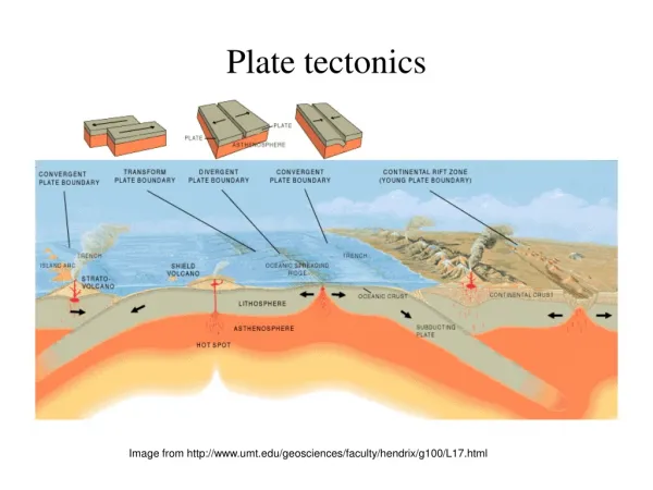
RADARSAT Response to Various Surface Features • Radar backscatter (detected intensity) is directly related to topography, dielectric properties, and surface roughness Reflection Type: Image Appearance: GREY – speckled DARK - smooth BRIGHT Adapted from: RADARSAT International 1996. Radarsat Geology Handbook. Richmond, B.C.
RADARSAT Response to Various Surface Features Adapted from: RADARSAT International 1996. Radarsat Geology Handbook. Richmond, B.C.
RADARSAT-1 Uses • Surface roughness • MTRI road quality study, oil spill monitoring, land cover/land use • Moisture • Watershed budget studies, wetland monitoring, seasonal change detection for lineaments • Land/water boundaries • Shipping routes, change detection – drought and flood events • Anthropogenic features • Land cover/land use , change detection – agricultural studies • Topography • Geological mapping (including structural information), surface drainage pattern detection • Two images with different look angles or pass directions can be fused to create DEMs
RADARSAT-1 Uses …example • Imaging of tropical places RADARSAT International 1996. Radarsat Geology Handbook. Richmond, B.C.
RADARSAT-1 Uses …example • Geological mapping: NNW Canada RADARSAT International 1996. Radarsat Geology Handbook. Richmond, B.C.
RADARSAT-1 Uses …example • Volcanic lithology: Kamchatka Peninsula, Russia RADARSAT International 1996. Radarsat Geology Handbook. Richmond, B.C.
RADARSAT-1 Uses …example • Tree-top geology: Indonesia RADARSAT International 1996. Radarsat Geology Handbook. Richmond, B.C.
RADARSAT-1 Uses …example • Oil spill: South Korea http://earthobservatory.nasa.gov/NaturalHazards/Archive/Dec2007/SouthKorea_ASA_2007345_lrg.jpg
RADARSAT-1 Uses …example • Water resource management: near Boaco, Nicaragua Image created by J. N. Bruning 10/15/07
RADARSAT-1 Uses …example • Agricultural monitoring: near Lake Nicaragua Image created by J. N. Bruning 10/17/07
SAR Uses … example • Surface of Venus, as imaged by the Magellan probe using SAR
Distortions Inherent to SAR • Foreshortening • Layover • Shadowing • Radiometric Effects • Suppression of Structure • Speckle • … How to overcome distortions? RADARSAT International 1996. Radarsat Geology Handbook. Richmond, B.C.
Distortion Inherent to SAR …Foreshortening • Foreshortening • The slant range distance (1) is smaller than the actual ground distance (2) RADARSAT International 1996. Radarsat Geology Handbook. Richmond, B.C.
Distortion Inherent to SAR …Layover • Layover • The top of the mountain (B) is viewed before the bottom of the mountain (A) RADARSAT International 1996. Radarsat Geology Handbook. Richmond, B.C.
Distortion Inherent to SAR …Shadowing • Shadowing • The shadow area is not imaged RADARSAT International 1996. Radarsat Geology Handbook. Richmond, B.C.
Distortion Inherent to SAR …Radiometric Effects • Sensor-facing slopes are bright and the leeward slopes are dark, despite the valley having symmetrical slopes and similar land cover • Which way was the sensor looking? • Which way was the sensor traveling? Adapted from: RADARSAT International 1996. Radarsat Geology Handbook. Richmond, B.C.
Distortion Inherent to SAR …Suppression of Structure • Fusing ascending imagery with descending imagery overcomes lineament suppression zone DESCENDING ORBIT ASCENDING ORBIT Adapted from: RADARSAT International 1996. Radarsat Geology Handbook. Richmond, B.C.
Distortion Inherent to SAR …Speckle • Definition: Spatially random multiplicative noise due to coherent superposition of multiple backscatter sources within a SAR resolution element • Images have grainy appearance Image from: www.earth.esa.int
Distortion Inherent to SAR …How to overcome distortions? • Select the appropriate image • Understand target phenomenology • Some distortions enhance certain features • Order >1 image • Processing methods • Terrain correction • Smoothing for speckle reduction • Multi-date/multi-sensor stacks • Ascending and descending pair stacks • … Trial and error
What to order? … continued • Beam modes • Size of study area • At what scale will your observations be made? • Mosaic of several images – same look direction • Type of features to detect • Sensitivity to incidence angle – terrain conditions • Alignment of features • Stereo imagery • Temporal coverage • Scale of features • Often limited by available data for a study location
Processing flow • L0 data - ? • L1 data • ASF convert tool – free download from ASF web site • Terrain correction • Requires DEM • Radiometric correction option • Interpolation options • Masking options • Geolocation correction • Can use DEM • Or… use another program • ENVI, ERDAS Imagine, ArcGIS • Smoothing (?) • Fusing with other images/data sets
Processing flow … continued • EXAMPLE: Cook Inlet, Alaska RADARSAT (Standard beam mode, descending orbit) 1. Original Image 2. Terrain Corrected 3. Terrain Corrected & Geolocation Corrected Adapted from: ASF Convert Manual, pg. 40 – 43.
Radar Resources • Alaska Satellite Facility • http://www.asf.alaska.edu/index.html • Free JERS-1 mosaics • SAR FAQ • Data credit grants (NASA) = free data • Convert Tool – free SAR data processor • RADARSAT International 1996. RADARSAT Geology Handbook. Richmond, B.C. • CROSS • https://cross.restec.or.jp/cross/CfcLogin.do?locale=en
ASTER RADARSAT
Spectral Resolution • RADARSAT-1 SAR: C-Band, 5.6 cm wavelength • ASTER: 14 Bands (in 3 packages) • QuickBird: 4 Bands