Download
1 / 23
230 likes | 316 Views
CROSS VALIDATION OF SATELLITE RADIATION TRANSFER MODELS. Enio B. Pereira Fernando R. Martins Brazilian Institute for Space Research - INPE, São José dos Campos, Brazil. Solar and Wind Energy Resource Assessment (SWERA) project. multinational project financed by UNEP-GEF aimed at:

E N D
CROSS VALIDATION OF SATELLITE RADIATION TRANSFER MODELS Enio B. Pereira Fernando R. Martins Brazilian Institute for Space Research - INPE, São José dos Campos, Brazil.
Solar and Wind Energy Resource Assessment (SWERA) project • multinational project financed by UNEP-GEF • aimed at: • performing a detailed survey of solar and wind energy resources in several developing countries • employing the most modern available modeling techniques and using country available ground data • in response to the international concerns on the increasing demands for energy in developing countries • to provide reliable information necessary to conciliate development and environment protection
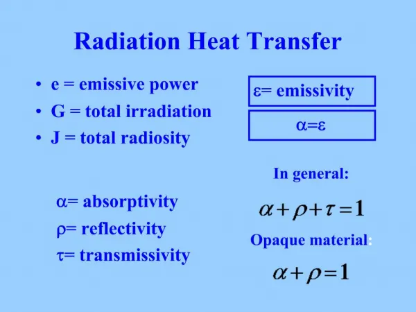
Solar AssessmentRadiative Transfer Models used in SWERA project • BRASIL-SR model:a spectral model that combines satellite data, climatological information and the “two-stream approach” to solve the radiative transfer equation • SUNY-Albany model:statistical satellite method based on the Kasten’s formulation and cloud index obtained from satellite images • DLR model:method for direct normal irradiance using the cloud transmittance obtained from an empirical expression of the cloud index derived from IR and VIS satellite images • NREL model:climatic-based model for global solar irradiance estimation using gridded cloud fraction coverage assembled by the US Air Force
Goals One of most important task of SWERA-solar component is the cross validation among the project’s core radiation transfer models In this presentation I will report the first results from two of the models: BRASIL-SR and SUNY-Albany and use HELIOSAT as reference model
Reference model HELIOSAT model: • method that uses: • Linke turbidity to parameterize atmospheric contribution to radiative transmittance and • cloud index derived from satellite images to model cloud extinction • a reliable model with many good results published for Europe and Africa in scientific journals • uses METEOSAT data to derive cloud index used to model cloud extinction
Description of ground sites The three sites were chosen because: • provide high quality radiation data and • represent different climatic/environmental regions and different ground cover. Site 1 – Caicó (06°28’01”S – 037°05’05”W / 176m) Site 2 – Florianópolis (27°34’18”S – 048°31’42”W / 10m) Site 3 – Balbina (01°55’07”S – 059°25’59”W / 230m)
Basic description of ground sitesSite 1 - Caicó (06°28’01”S – 037°05’05”W / 176m) • Semi-arid region of the Brazilian northeast • Annual precipitation less than 700 mm • Flat land area with sparse brushwood type vegetation • Average albedo 13.3% • Large insolation - about 120 days/year • High annual mean temperature - 22 to 33 oC • Nice place for clear-sky bias model fine tuning • Producing data for global and direct incident horizontal solar radiation since November 2002.
Basic description of ground sitesSite 1 - Caicó (06°28’01”S – 037°05’05”W / 176m)
Basic description of ground sitesSite 2 - Florianópolis(27°34’18”S – 048°31’42”W / 10m) • Located at coastal area of the Brazilian South region In a medium size city (under 400,000 inhabitants) Rains is fairly well distributed along the year Summer is hot and the winter is mild with some few cold days • Installed in 1991 as part of the BSRN and provides data of global, direct, and diffuse radiation.
Basic description of ground sitesSite 2 – Florianópolis (27°34’18”S – 048°31’42”W / 10m)
Basic description of ground sitesSite 3 – Balbina (01°55’07”S – 059°25’59”W / 230m) • It is a BSRN station located in a small village : Close to a large hydroelectric power plant In the middle of the Brazilian rain forest in the Amazon region. Temperatures are high along the year Precipitation is high and concentrated in the November to April • This station has some operating problems and provided only global radiation during the cross validation time period.
Basic description of ground sitesSite 3 – Balbina (01°55’07”S – 059°25’59”W / 230m)
Satellite Data Coverage area map of GOES-EAST (0°- 75°W/36,000 km) Coverage area map of METEOSAT (0°- 0°/36,000 km)
GOES-8 images for South America visible channel (0.52 - 0.75mm) infrared channel (10.2 - 11.2mm) Images obtained through GOES-8 on 02/18/1999 at 14h45 UTC
METEOSAT images for South America visible channel (0.45 - 1.0mm) Images obtained through METEOSAT on 01/21/2003 at 15h00 UTC
Cross ValidationPreliminary Results • Cross validation period begun in November/2002 and is still being carried out • Only BRASIL-SR and SUNY-Albany results are here presented • NREL and DLR models are not yet available, but they will be included in the comparison analysis in a latter phase of the project • Three benchmarks were used to evaluate the quality of global solar estimates: • relative mean bias error (rMBE) • relative root mean square error (rRMSE) • relative root mean square for “percentile match curves” (rRMSEpm)
Comparison for daily dataSite 1 – Caicó Units:W.h.m-2
Comparison for daily dataSite 2 – Florianópolis Units:W.h.m-2
Comparison for daily dataSite 3 – Balbina Units:W.h.m-2
Conclusions • From the preliminary cross-validation we concluded that: • Both BRASIL-SR and the SUNY-Albany produced estimates that are statistically comparable for the studied sites • Correlation factors are good in both core models for hourly and daily estimates • There is a need to improve both methods to obtain better estimations of cloud cover index in order to cope with situations where the skyis cloudless most of the year such as in Caicó • There still remains a lot to do in terms of validation and model adjustments before operational procedures using the core models