Download
1 / 12
120 likes | 432 Views
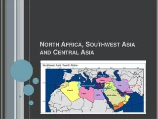
Southwest PA/Wheeling Sub-Area Contingency Plan. Status Report 9/13/2011 Marjorie Easton, USEPA OSC CDR Richard Timme , USCG MSU Pittsburgh. SWPA/Wheeling Sub-Area Counties. Plan Overview. Purpose and Objective Statutory Authority – 40 CFR Part 300; CERCLA; CWA (OPA)

E N D
Southwest PA/Wheeling Sub-Area Contingency Plan Status Report 9/13/2011 Marjorie Easton, USEPA OSC CDR Richard Timme, USCG MSU Pittsburgh
Plan Overview • Purpose and Objective • Statutory Authority – 40 CFR Part 300; CERCLA; CWA (OPA) • Scope of Plan – Oil and Chemical • Plan Format – Text Revision/add Geographical Response Plan Mapping component • Concise and Focused
Plan Revision/Overhaul – Progress Made • Organize Workgroup • Specific Invitees – USCG, PADEP, WVDEP, WVDNR, PA Fish&Boat, TRPRC, etc. • Other participation not excluded • Meet at least once per month • Iterative review process • Industry partnership (TRPRC) • Developing Table of Contents • Reviewed numerous sub-area plans/models/TOCs • Workgroup helped decide on best TOC example
Plan Organization • River Oriented – not exclusive of other sub-area geography • Organized Macro to Micro (Federal down to local, except for notification) • Describes and references resources rather than reinventing wheel – no dead ends • Includes section on Elected Officials
Other Components – Information Sheets • Revising County Fact Sheets – need to be updated periodically due to changing representatives/information • Developing FRP Summary Sheets – Physical review of each FRP – will be available via hyperlink in GRP mapping component
Geographical Response Plan (GRP) Mapping Component (breakout workgroup) • Format (PDF, then ArcReader/Google Earth) • Data Layers to be included – based on 19 Essential Elements - initially to map potential sources and targets • Scale to be used
GRP Issues and Concerns • Substance without clutter • Sensitivity – separate version for general public • Data ownership • Maintenance – living document