Download
1 / 3
30 likes | 166 Views
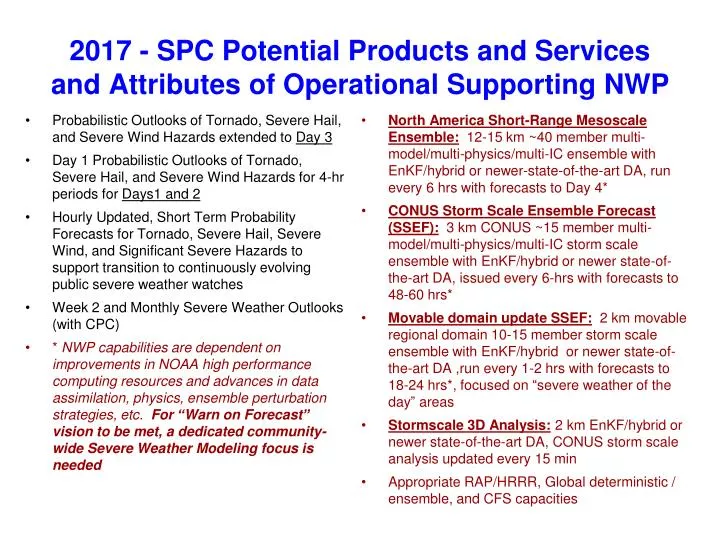
2017 - SPC Potential Products and Services and Attributes of Operational Supporting NWP. Probabilistic Outlooks of Tornado, Severe Hail, and Severe Wind Hazards extended to Day 3 Day 1 Probabilistic Outlooks of Tornado, Severe Hail, and Severe Wind Hazards for 4-hr periods for Days1 and 2

E N D
2017 - SPC Potential Products and Services and Attributes of Operational Supporting NWP • Probabilistic Outlooks of Tornado, Severe Hail, and Severe Wind Hazards extended to Day 3 • Day 1 Probabilistic Outlooks of Tornado, Severe Hail, and Severe Wind Hazards for 4-hr periods for Days1 and 2 • Hourly Updated, Short Term Probability Forecasts for Tornado, Severe Hail, Severe Wind, and Significant Severe Hazards to support transition to continuously evolving public severe weather watches • Week 2 and Monthly Severe Weather Outlooks (with CPC) • * NWP capabilities are dependent on improvements in NOAA high performance computing resources and advances in data assimilation, physics, ensemble perturbation strategies, etc. For “Warn on Forecast” vision to be met, a dedicated community-wide Severe Weather Modeling focus is needed • North America Short-Range Mesoscale Ensemble: 12-15 km ~40 member multi-model/multi-physics/multi-IC ensemble with EnKF/hybrid or newer-state-of-the-art DA, run every 6 hrs with forecasts to Day 4* • CONUS Storm Scale Ensemble Forecast (SSEF): 3 km CONUS ~15 member multi-model/multi-physics/multi-IC storm scale ensemble with EnKF/hybrid or newer state-of-the-art DA, issued every 6-hrs with forecasts to 48-60 hrs* • Movable domain update SSEF: 2 km movable regional domain 10-15 member storm scale ensemble with EnKF/hybrid or newer state-of-the-art DA ,run every 1-2 hrs with forecasts to 18-24 hrs*, focused on “severe weather of the day” areas • Stormscale 3D Analysis:2 km EnKF/hybrid or newer state-of-the-art DA, CONUS storm scale analysis updated every 15 min • Appropriate RAP/HRRR, Global deterministic / ensemble, and CFS capacities
Operational Ensemble System Vision 2020 • Many science and HPC challenges for stormscale EPS • Better Models Produce Better Ensembles • A dedicated focus on deterministic high resolution model improvement will still be needed • Model Resolution • Horizontal: 3-4 km grid spacing resolves MCSs and some stormscale structures • Earlier studies indicated little qualitative difference between 2 and 4 km • However, these focused on spring environments when CAPE is large • Cool season cases in High Shear/Low CAPE environments suggest 3-4 km grid spacing may be insufficient to resolve low CAPE tornadicsupercells => is finer resolution needed in low CAPE environments? • Vertical: what is relationship between horizontal and vertical resolution? Is more vertical resolution needed as we move down toward stormscale?
Operational Ensemble System Vision 2020 • Many science and HPC challenges for stormscale EPS • Current plans focus on ARW and NMMB membership • Is a multi-model system better on convective scales? How much do multiple models contribute to stormscale ensemble spread? • Perturbation strategies • CAPS SSEF has utilized SREF IC perturbations to provide IC diversity • What are scale-appropriate IC perturbations where convective storm error growth is large in time/space compared to mesoscale error growth? • Forecast length for stormscale models? • Current NAM Nest runs to 60 hrs and High Res Windows run to 48 hrs • While these are useful in constructing time-lagged ensemble members, do they contribute to meaningful ensemble spread for a Day 1 forecast? • More importantly, what is the predictability of convective storms beyond the first diurnal heating cycle, and how does this inform us about the effective use of HPC resources for stormscale modeling?