Download
1 / 20
260 likes | 530 Views
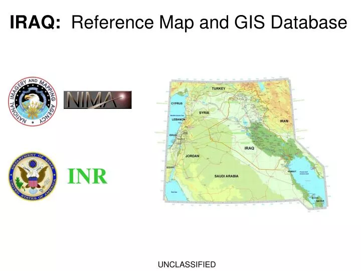
IRAQ: Reference Map and GIS Database. INR. UNCLASSIFIED. IRAQ: Reference Map and GIS Database.

E N D
IRAQ: Reference Map and GIS Database INR UNCLASSIFIED
IRAQ: Reference Map and GIS Database • The original Iraq Reference Map (plotted size: 34” high x 60” wide) is available from NIMA as an ArcView project. The ArcView project and associated data layers are included on the IRAQ_GIS CD-ROM. In addition, ArcGIS projects (.mxd files) have been created for the maps (Main Map and eight inset maps) shown on the Iraq Reference Map. • Main Map • Provinces • Distances • Southern Marshes • Holy Sites (2 insets) • Oil Industry • Power Infrastructure
IRAQ: Additional Open-source datasets • In addition to the ArcView shapefile vector layers included in the Iraq Reference Map, we added Iraq NIMA GeoNames and several raster data layers: TERRA MODIS satellite imagery products, elevation data and population data. ArcGIS .mxd projects were created to display these layers. • MODIS true-color satellite image • MODIS-derived LandCover • City Night Lights (DMSP) satellite image • LandScan 2001 population layer • GTOPO30 elevation layer (DTED Level 0) • GTOPO30-derived elevation-tinted shaded relief • NIMA GeoNames vector layer (point shapefile)
IRAQ: TERRA MODIS True-color Satellite Image (1km) This is a MODIS (MODerate Resolution Imaging Spectrometer) MOD09A1 true-color satellite image, resampled to 1km pixel resolution.. The MODIS sensor is on board the NASA TERRA satellite. Source: NASA/GSFC/SSAI
IRAQ: LandScan 2001 population layer LandScan 2001 is an estimate of population density, showing number of people per 30”x30” gridcell (approx. 1km²). LandScan data is included in ArcInfo GRID and ERDAS .img format. LandScan is produced by ORNL (Oak Ridge National Laboratory) for use in humanitarian disaster response and planning.
IRAQ: TERRA MODIS Landcover This is an Land Cover thematic raster layer containing 16 landcover classes. The landcover classes are derived from multispectral MODIS data. Shown here: Barren (gray) Open shrublands (lt purple) Grassland (tan) Cropland (lt yellow) Cropland/Nat.Vegetation (brown) 1km pixel resolution. Source: Center for Remote Sensing, Dept of Geography, Boston University
IRAQ: GTOPO30 Elevation Layer This is an elevation-tinted view of the elevation layer. The original file is an ArcInfo GRID raster layer called IZGTOPO30. The data has also been imported into an ERDAS .img layer called iz_gtopo30.img. The GTOPO30 data is also known as DTED Level 0. It has a 30” resolution (approx. 1km). NOTE: In the GRID layer, null data (ocean) pixels have data value -9999. In the .img layer, null data pixels have data value -32,768.
IRAQ: GTOPO30 Elevation as Shaded Relief Detail This is an elevation-tinted shaded-relief view of the elevation layer. The shaded relief was created in ERDAS Imagine and saved as a 24-bit RGB image called IZ_GTOPO30_shd.img
IRAQ: City Night Lights (satellite image) The Night Lights imagery was created with data from the Defense Meteorological Satellite Program (DMSP) Operational Linescan System (OLS), available from NASA. The image used here is an 8-bit ERDAS layer called nightlights_1km.img
IRAQ: NIMA GeoNames The Iraq GeoNames layer contains point locations and names for all the Named Places in Iraq from the NIMA GeoNames database. A DSG (Designation) code specifies the type of Named Place. For example: ADM1 Admin. region MT Mountain PPL Populated Place STM Stream The majority of named points are Populated Places (cities, towns, villages). The GeoNames layer is saved as a shapefile called IZgeonames.shp
IRAQ: Reference Map and GIS Database Points of Contact: Shawn Mason masonsh@nima.mil (202) 647-0321 David Carey careydp@state.gov careyd@nima.mil (202) 647-1335 NIMA Support Team Department of State, INR/GGI/GIU INR