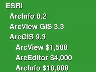
Download
1 / 12
120 likes | 243 Views
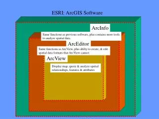
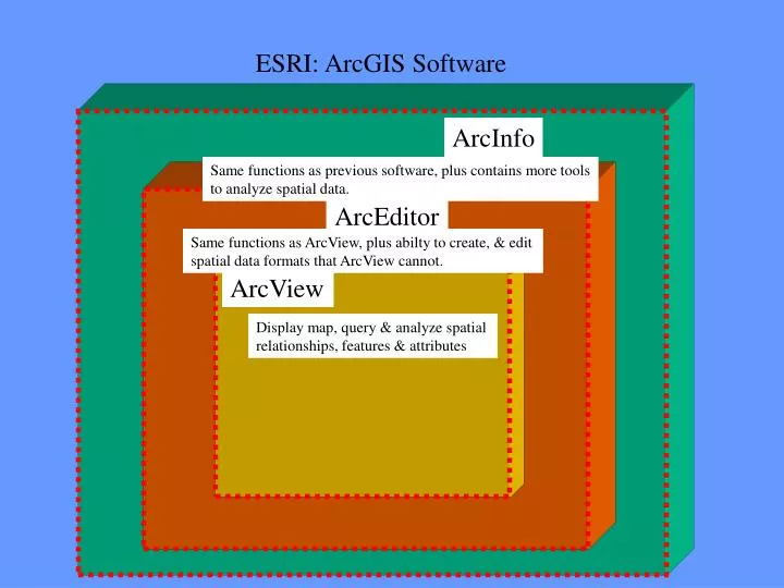
Same functions as previous software, plus contains more tools to analyze spatial data. Same functions as ArcView, plus abilty to create, & edit spatial data formats that ArcView cannot. Display map, query & analyze spatial relationships, features & attributes. ESRI: ArcGIS Software.

E N D
Same functions as previous software, plus contains more tools to analyze spatial data. Same functions as ArcView, plus abilty to create, & edit spatial data formats that ArcView cannot. Display map, query & analyze spatial relationships, features & attributes ESRI: ArcGIS Software ArcInfo ArcEditor ArcView
ArcGIS ArcView, ArcEditor, & ArcInfo are transparent to the user: • user does not need to know software type for • many GIS functions & applications • can open, display, & query data from any of • the 3 softwares.
Training focus will be • View & display data by color & symbol • Create thematic maps • Find/ locate attribute data on maps • Query and analyze data through spatial & attribute characteristics • Edit features • Creating presentation quality maps to print • ArcMap will be the application used, with some ArcCatalog & ArcToolbox functions
ArcGIS is composed of 3 applications: • ArcMap • ArcCatalog • ArcToolBox
ArcMap: • Create maps from spatial data • Choose colors and map symbols • Analyze spatial relationships • Design map layouts for printing
ArcCatalog: • Browse spatial data (hard drive, network, or internet) • Preview spatial data & add it to ArcMap • Create & view metadata (information about the data such as source, creation date, description, etc.)
ArcToolBox: • Tools to convert data from different formats Change to or from shapefiles, coverages, tables, or geodatababases • Tools to manage data Aggregate, generalize, projections, topology, etc. • Tools to analyze data Extract, overlay, proximity, statistics, or surface
MainMenuToolbar Standard Toolbar DataFrame Table of Contents Map Display Tools Toolbar Drawing Toolbar
01_Exercise_ArcGIS • Open & display data through use of a map document (.mxd) - map document (.mxd) window. The data layers’ characteristics contain settings such as pre-set colors, line thickness, fill, and a specific view or scale. • Add to the Table Of Contents (TOC): - layer A category of the data to display in the ArcMap display window as well as listed in the table of contents; Layers can be many formats- shapefiles, coverages, geodatabase features, raster, etc. - data frame A collection of data layers that displays in the display view window. Multiple data frames can exist in a map document.
01_Exercise • Context menu- right click a layer in TOCto display the context menu contains many more GIS options of the data layer • Navigate using Tools Toolbar such as pan, zoom in & out, identify, and find.
01_Exercise • Open / Save Map Document • Layer Properties:Changing the appearance of displayed data symbols • Open data layers from Arc GIS filetypes: shapefile, coverage and geodatabase feature class • Type Name on Map & Print the map window