Download
1 / 21
210 likes | 216 Views
A Virtual Observatory for the Ionosphere-Mesosphere-Thermosphere Community. D. Morrison, M. Weiss, R. Daley, L. Immer, S. Nylund, J.-H. Yee, and E. Talaat (Johns Hopkins University, Applied Physics Laboratory 11100 Johns Hopkins Rd. Laurel MD, 20723: 240-228-4172) J. Russell

E N D
A Virtual Observatory for the Ionosphere-Mesosphere-Thermosphere Community D. Morrison, M. Weiss, R. Daley, L. Immer, S. Nylund, J.-H. Yee, and E. Talaat (Johns Hopkins University, Applied Physics Laboratory 11100 Johns Hopkins Rd. Laurel MD, 20723: 240-228-4172) J. Russell (Hampton University) R. Heelis (Univ. Texas at Dallas) J. Kozyra (Univ. of Michigan) D. Bilitza, R. McGuire, and R. Candey (NASA Goddard Spaceflight Center) P. Fox (HAO/NCAR) SM23A-06
Virtual ITM Observatory • The Virtual ITM Observatory (VITMO) is one of the recently awarded domain specific NASA virtual observatories (VxO). • VITMO will focus on data covering the ITM region as well as providing connections to the energy drivers for this region (principally solar and magnetospheric). SM23A-06
What is a VxO? • An observatory is a location used for observing terrestrial and/or celestial events. • A virtual observatory is a system that allows an observer to work as if they were at the observatory. • The VO does this typically by allowing the observer to access multiple data files (“observations”) from multiple sources of the object of interest. • The VO allows access to “different instruments” to study a given system or phenomena. • A VxO is a virtual observatory that focuses on a particular domain such as solar, magnetospheric, or ITM. SM23A-06
Virtual Observatory Concepts • Discovery of Data • “one-stop shopping” for the ITM community • Browsing - more than data query, enhanced by use of meta-data • Different views as data use differs between users • Delivery of / access to readers, and other tools • ITM is a heterogeneous data community with diverse file formats and granularity of observables • Distributed Access • Data providers have an integral role to provide data access, description, and meta-data • Adaptable framework responsive to community needs and requests • Comprehensive and historical SM23A-06
ITM is Diverse in Observables An ITM VO must facilitate correlative study between multiple parameters from multiple sources and cross-discipline studies. SM23A-06
ITM Domain Differences • Data covering the ITM region has a number of differences from data in other domains. • The ITM region is observed by ground based remote sensing instruments, satellite based remote sensing instruments, and in-situ satellite instruments. • There are external drivers in solar radiation and the solar wind and magnetospheric particle inputs. • A Virtual Observatory that covers the ITM region needs to deal with the large diversity of data types in the study of this region. • A heterogeneous data format environment also exists here. • Solar imagery is typically in FITS files, ground based data are typically ASCII or NetCDF, in-situ satellite data are commonly in CDF format, remote sensing satellite data are typically HDF, NetCDF, or CDF. • Non-NASA data sources (i.e. NSF, NOAA, DoD) are important contributors to the ITM domain. SM23A-06
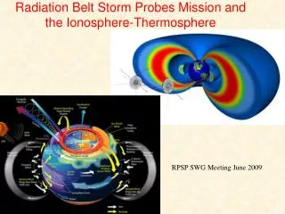
The Ability to Find the Appropriate Data Will Be a Key Requirement of a VITMO Increasingly satellites in the ITM community will rely on remote sensing instruments – TIMED, DMSP, NPOESS SM23A-06
How the VITMO Will Be Different • For a VxO to be truly useful it must go beyond traditional mission data centers. • It should be able to interrogate multiple data centers, finding products that overlap in time and/or location. • It must allow a higher level of search to be performed than previously available. An example of such a complex search would be something like the following: “what near Earth orbiters are observing the auroral region when Bz is negative and the solar wind speed is greater than 400 km / sec.?” Today, this would require a manual process where the researcher would first find plots of the Earth’s magnetic field component (Bz) and plots of solar wind speed from NASA’s CDAWeb (http://cdaweb.nasa.gsfc.gov). After they manually looked for overlap conditions they would utilize these time periods to search known Earth orbiters to find out if they were observing during those time periods. They would then have to manually review summary products to determine if those orbiters were viewing the auroral region during those intervals. VITMO will handle these types of queries automatically. • VITMO will also be able to organize tools, whether plotting, subsetting, or analysis tools by the type of data they are to be applied to as well as the types of operations that are to be performed. If the user requested time series data then tools appropriate for operating on the time series should be presented to them. If they chose images then tools appropriate for images should be made available. If the data were in CDF format, then FITS format data tools need not be presented. Additionally, VITMO will understand that model output can be treated as high level data products and that models should be available, just as tools are, to the end user. SM23A-06
VITMO Architecture Overview • high-level conceptual model of the scientific disciplines and domain data in the region from the Sun to the Earth • Regions – Solar, Near-Earth – F-region, E-region • Features – exist for long periods of time • Events – Occur at particular points in time • description of resource metadata in the Knowledge Base supporting any accessible scientific resource • descriptive metadata includes program, satellite and instrument information, as well as data details like observed phenomena, units of measure, time and spatial coverage, processing level • structural metadata defines the details for data access and retrieval if selected by the use • expand the notion of a data resource in our metadata definition to also include databases and computer programs (such as format conversion tools or data models) that generate requested data on demand. Thus, file access, database access, and program invocation details are all included in the resource metadata model. SM23A-06
Coupling in VITMO Architecture • a loose coupling between the conceptual model and the resource metadata. • A query in the conceptual model identifies the desired parameters, which are then mapped to the related data resources. Data discovery is simplified by performing requests at the conceptual level, permitting users without knowledge of specific mission, or instrument to readily find data of interest. • conceptual model can be readily expanded if new classes of scientific concepts or new relationships between scientific concept classes would improve the model's representation of the Sun to Earth domain. • a data provider can add resources (of any format, access method, or processing level) simply by providing information that describes the data and its access details. • model eliminates the need for rigid metadata standards or unique, resource-specific integration software SM23A-06
VITMO Based on Services SM23A-06
Enhanced Search Services • Today’s researcher needs to find datasets from different missions that overlap in time and space. • Many of today’s satellite missions include remote sensing instruments. Finding cross comparisons between instruments is more difficult because we must be concerned not just with spacecraft location, but also with multiple look-points for the instruments. • The prime NASA mission for study of the MLT region is the TIMED satellite. All of the instruments on this satellite are remote sensing instruments. Each remote sensing instrument has a different look geometry, some looking as far as 2000 km away from the satellite. SM23A-06
Enhanced Search Services Continued • AIM will have a fly’s eye imager. • The fields-of-view (regard) of these instruments define the extent of the data products. • This location information is not contained in the existing metadata in today’s catalogs. SM23A-06
Virtual Metadata Generators • VITMO will employ special coincidence calculators that know the viewing geometries of the various instruments. • The TIMED coincidence calculator is an example of a tool which when converted into a web service can be used to augment existing data querying. • The TIMED coincidence calculator has recently been imbedded into the TIMED query system. • These calculators will operate as web services inside the VITMO query system (or by outside query systems). • These calculators generate metadata for the coincidence of interest which is used by the catalog system to answer your query. • The metadata generated by this service is discarded after it is used – hence “virtual metadata”. SM23A-06
Enhanced Search Results • Addition of virtual metadata capabilities allows pre-selection of data for analysis. • VITMO search will deliver results from searches such as “What GUVI data that contains 23-01 MLT during active geomagnetic conditions?” SM23A-06
Prototype Display The left hand side of the web page allows the user to search or browse for resources (be they data, models, tools, etc) by the particular region of space, time, satellite coincidences or other criteria. After resources are searched for the results are displayed and possible display plots may be shown. If the user selects the “Related Tools and Models” button on the top of the page a display of appropriate tools and models for the data or resources chosen will be presented. This list of tools and models is generated dynamically based on the metadata in the VITMO catalog describing the data, tools, and models available through the VITMO. SM23A-06
Uniqueness of the Proposed Approach • Unique search capabilities allowing complex overlapping searches to be performed, eliminating much of the tedious work of finding the appropriate data sets • architecture that builds on the latest technologies like web services, but flexible enough that it can accommodate new technologies, not yet available • simplified metadata description that allows new data sets and data servers to be easily added • a design that incorporates more than data, that includes models and tools as well • a design that builds on existing data centers rather than duplicating their functions • an approach that was designed for low long-term maintenance costs in the future • a team that represents the major future ITM satellite missions and the major ITM-related data centers and services SM23A-06
Halloween 2003 Superstorm as an Example Increasingly satellites in the ITM community will rely on remote sensing instruments – TIMED, DMSP, NPOESS SM23A-06
What will VITMO mean to users? • By taking on a more global view of data, VITMO can help the researcher understand the connectedness between the different data sets. • Example - storm studies - taking the Halloween 2003 superstorm as a case study. • During this event the following things happened: (1) 3 active regions (ARs) produced a total of at least 124 soft X-ray flares and > 60 coronal mass ejections (CMEs) between Oct. 18 and Nov. 5, 2003. (2) 2 CMEs impacted Earth head-on producing huge geomagnetic storms. • Today: • A researcher may start with: LASCO images and ACE solar wind data over the broad time range in October and November 2003. If the researcher was interested in auroral impacts from the storm they may have looked for time periods when Kp was between 3 and 9 and Bz was negative. • They might have looked for Polar and GUVI imagery or auroral conductivity maps during those time periods. • All of this work would have involved finding and navigating numerous web sites that provide data, indices, and other information for the specific time period. • Tomorrow – with VITMO: • The researcher will be able to select the needed LASCO images and ACE solar wind data. • They will also be able to select auroral data during the time periods when Kp is between 3 and 9 and Bz was negative. • The VITMO, knowing that the researcher was interested in auroral data, would have automatically presented GUVI and Polar instrument products as appropriate. • It would then suggest data readers, appropriate for the data format, and tools that the researcher could use to work with or analyze that data. SM23A-06
Resources Supported • TIMED, AIM, SNOE, C/NOFS, UARS, SuperDARN, DMSP • CDAWeb, SSCWeb, ModelWeb, VSTO • Other VxO’s • NGDC SM23A-06