Download
1 / 26
260 likes | 340 Views
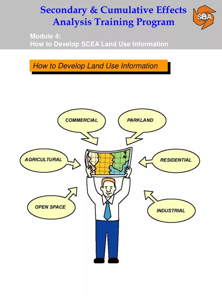
How to Develop Land Use Information. Factors to Consider. Developing and mapping land use information is part of the analysis section of conducting a SCEA.

E N D
Factors to Consider • Developing and mapping land use information is part of the analysis section of conducting a SCEA. • Because of its importance to the analysis process, the development of land use is being treated as a separate section in the training seminar. SCEA DO Be aware of how the development and mapping of land use information fits into the overall analysis of resources. Note that the analysis section of conducting a SCEA is discussed in detail in Module 5. Determine Level of SCEA Analysis Collect Resource Data Identify Regulatory Programs Map Resources & Land Use Identify Methodologies/ Conduct Analysis
Land Use Types Generally Considered • Agricultural • Residential • Commercial • Industrial • Open Space • Parkland • Other
Land Use Considerations • Land Use Considerations • Past Land Use • Present Land Use • Future Land Use
Land Use Considerations • Why Develop Land Use Information • Past Land Use • - Provides a baseline from which trends can be developed. • Present Land Use • - Provides an intermediate year from which trends can be determined. • - Provides a current analysis year to conduct overlay analysis. • Future Land Use • - Provides a build-out analysis year to conduct overlay analysis.
Mapping Land Use SCEA DO As part of the process for developing land use, map any available data sources. This will be helpful in preparing the data for the analysis methodologies that will be presented in Module 5. Be sure to map land use once all available data sources have been collected. Only land use information within the SCEA geographic boundary should be mapped.
Past Land Use Key Past Land Use Data Sources
Present Land Use Key Present Land Use Data Sources NOTE: Near future (1 - 5 years) counts in present time period for land use.
Present Land Use SCEA CAUTION The appropriate development size(s) (i.e., subdivisions of a certain number of units, etc.) to be analyzed must be determined on a project-by-project basis. It is not necessary to scour the entire SCEA study area for proposed development such as individual residential lots less than one acre. Be sure to document the rationale for why a particular development size was chosen.
Present Land Use SHA Regional & Intermodal Planning Division (RIPD) Major Development Matrix • Urban Developments - 500 units residential, 5,000 square feet commercial and 1,000,000 square feet industrial. • Rural developments - 250 units residential, 2500 square feet commercial and 500,000 square feet industrial.
Future Land Use Key Future Land Use Data Sources
Future Land Use • Development of future land use scenarios (done for each alternative including the no-build) for SCEA is primarily based on two sources: • Travel Forecasts - Review and map future land uses with assumptions based on travel forecasts. • Local/Regional Planning Resources - Meet with local planners and utilize planning resources such as the Regional & Intermodal Planning Division (RIPD), Metropolitan Planning Organizations, the Constrained Long Range Plan (CLRP) and local master plans to develop future land use scenarios.
Future Land Use Future Land Use Data Sources In special cases, “Expert Land Use Panels” can be convened to identify future land use scenarios, if a project is especially complex or if local jurisdictions, agencies or special interest groups disagree that a particular land use will or will not occur. The “Expert Land Use Panels” are not required when developing land use for a SCEA, but are considered on a project by project basis.
Key Future Land Use Data Sources • SCEA DO • In situations where two or more different future land use scenarios are predicted for a project alternative: • Determine the scenario that will most likely reflect future land use. • Try to come to an agreement; if you can’t, determine how to proceed on a project by project basis.
Middle River Employment Center Access Study (MRECAS) MRECAS Expert Land Use Team • Baltimore County originally performed an economic Analysis for properties designated for development under the county's economic development plan. • - This analysis was originally used to support SHA's Project Purpose and Need Statement. • - In general, the study was based upon projections of new business types and potential employee base associated with these businesses. • - The study determined that approximately 50% of the developable land would be developed. • The Environmental Resources Agencies requested that an independent study be performed to confirm the County’s findings prior to concurring upon the project purpose and need. NOTE: The MRECAS expert land use panel considered the development of land use within the area where secondary effect were expected to occur; not the whole SCEA geographic boundary.
Middle River Employment Center Access Study (MRECAS) MD 43 Expert Land Use Team (continued) • The independent study was performed by a team of real estate, development and engineering professionals. • - Environmental resources (wetlands, stream buffers, cemeteries, parks and schools) were subtracted out of the land designated for development to determine the total amount of actual developable land. • - The results of the analysis projected that the economic development plan would create 13,830 jobs and would require 7,274,520 s.f. (approximately 170 acres) of new development that may potentially be built-out over a 10-year period. • - It was therefore determined that the projected economic development could be accommodated within the county's developable land envelope (this includes consideration of environmental resources). • The study was found to be acceptable by the resource agencies and concurrence on the project purpose and need was attained.
Future Land Use Assessing Land Use for Cumulative Impacts The cumulative impact analysis must account for the secondary development resulting from a project alternative, plus any additional development within the SCEA geographical boundary that is not dependent upon a/the project alternative.
Future Land Use Types of Impacts That Cause Land Use Change Within a SCEA Boundary • Secondary Impacts - Land use changes that occur because of a Project Alternative. • Cumulative Impacts - Land use changes that would occur or have occurred regardless of a Project Alternative. Land use changes caused by secondary project impacts Cumulative land use changes resulting from non-project related impacts Total land use change in the SCEA geographic boundary = +
Future Land Use Coordination with Local Planning Officials Coordination with local governments and/or developers should indicate planned development that will not proceed without approval of a specific transportation alternative. NOTE: Planned development may be unique to each project alternative.
Future Land Use Coordination with Local Planning Officials Identify any local zoning implications and identify changes in land use or level of development that may occur as the result of each project alternative.
Future Land Use SCEA DO Your meeting with the local planners may be your most important coordination in developing your future land use scenario, especially in respect to secondary development. It is important to present alternatives mapping when identifying potential secondary impacts with local planners. This will help illustrate differences in land use changes that may result from two or more alternatives.
Future Land Use Access Control/or Lack of it • Access Controlled Facilities - Secondary impacts generally occur near intersection and interchange areas. • Non-access Controlled Facilities - Secondary impacts can be spread out over the entire direct impact study area (i.e. strip development).
MD 5 - Hughesville Transportation Improvement Project MD 5 Land Use Development Note that future development, as analyzed in the MD 5 EA, generally falls within a 1 -5 year timeframe. Under current SHA Guidelines, this development would be interpreted as being within the “present” time frame. MD 5 Land Use Note
MD 5 - Hughesville Transportation Improvement Project Proposed Major Developments in the SCEA Boundary
MD 5 - Hughesville Transportation Improvement Project Proposed Development and CTP areas in the SCEA Boundary
MD 5 - Hughesville Transportation Improvement Project • SCEA Guidelines recommend that land use from all three time frames be developed and mapped. Below are two main decisions in the SCEA process for MD 5 that are not consistent with SHA’s SCEA Guidelines. • Only some of the information for the present time frame existed as readily available. Based on current SHA Guidelines the MD 5 SCEA should document map development for all three time frames including rationale for not mapping existing readily available land use. • Some of the analysis methodologies used in determining secondary and cumulative effects did not necessitate mapping past, present or future land use. (It is good practice not to select analysis methodologies prior to completing acquisition of all land use materials. The availability of land use mapping should guide the rationale for which analysis methodologies to use).