Download
1 / 28
280 likes | 283 Views
in-situ ocean data, weather prediction, climate prediction, marine forecast, marine pollution tracking

E N D
JCOMMOPS Mathieu Belbeoch Argo Technical Coordinator, JCOMMOPS IOC/UNESCO Programme Specialist belbeoch@jcommops.org
Requirements for in-situ ocean data • Numerical Weather Prediction (NWP) • Air pressure, wind… • Marine forecast • Air pressure, wind, waves, SST, surface velocity… • Ocean modelling • T/S profiles, surface/sub-surface velocity… • Seasonal/inter-annual climate prediction • SST, T/S profiles… • Marine pollution detection & tracking • Surface velocity… • Satellite products calibration & validation • SST, wind, waves…
Requirements for in-situ ocean data • Marine pollution tracking (Prestige)
Requirements for in-situ ocean data • Aircraft & Drifting buoy observations (Erika)
Requirements for in-situ ocean data • Climate anomalies are affected by heat changes in the oceans. • 1998 Quebec ice storm
Requirements for in-situ ocean data • SST mixed-products (sat. + buoys + ships) • With computer models and in-situ/sat. data this heat content is now predictable
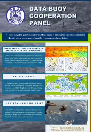
Observational prog. implementation • Funded & implemented nationally • International coordination required • Under GOOS/GCOS, JCOMM • Through dedicated Panels • DBCP, SOT, Argo • Between • Funding agencies • Platform operators, Prog. Managers, Principal Investigators • Data users • Satellite data telecommunication providers • Manufacturers • Data centres, archiving centres
Observational prog. implementation • Considering modest resources … • Synergy between observing systems • Cooperation between communities • Adequacy with requirements • Data sharing • Technical assistance • Global monitoring • Performance analyse • Provision of information … are required for an optimal efficiency
JCOMM in situ Observing Platform Support Centre • A component of the international coordination • Established by JCOMM-1, June 2001 • Coordination for Ship Observations Team included by JCOMM-2, September 2005 • Under JCOMM / OPA • Coordination facilities of • DBCP (drifting & moored buoys) • SOOP (XBTs) • Argo (subsurface profiling floats) • Two Coordinators • Information System (DB, GIS)
JCOMMOPS • Facilitating implementation & operations • Encouraging data exchange, including real-time • Day to day coordination, Technical assistance & expertise • Instrumentation • Satellite data telecommunication (synergy) • Data processing & exchange (synergy) • GTS (of WMO) • Internet • Flow to archiving centres • Performance monitoring
JCOMMOPS • Facilitating implementation & operations • Provision of information on • Requirements (WWW, GOOS/GCOS) • Programmes Monitoring (*) • maps, lists • Deployment opportunities (*) • Air/ship • Contact points • Instrumentation • Vandalism • Data systems, data access • Focal point / portal for information • Programmes promotion • Dialogue between meteorologists & oceanographers
JCOMMOPS • Support for private companies • Visibility • List of manufacturers on web site • News • Relay quality evaluation information • Quality evaluated by users & PIs • Independent source of information
JCOMMOPS is not a data centre • Provides information on how to get the data • Gather & QC basic metadata • Acts as a gateway • Buoy data • RNODC/DB: MEDS, Canada • SOC/DB: Météo France • XBT data • GTSPP: • MEDS, Canada • NOAA/NODC, USA • Argo data • GDAC: US GODAE server, Monterey • GDAC: French Coriolis centre, Brest
The Argo Project http://www.argo.net • What is Argo ? • A new way to collect data from the ocean using robot floats • « Take the pulse » of the Ocean’s upper layer in real-time • Complement to satellite and other in-situ observing systems • Access to data is free and unrestricted • Target- a 3° x 3° global array ( ~3000 floats) • Benefits: • Improve Ocean and Climate forecasting • Understand ocean-atmosphere interactions • Predict seasonal to decadal climate variability • Wide range of applications for high-quality global ocean analyses is anticipated
The Argo Project Standard Float Cycle • 150-200 cycles (4-5 years) • Temperature/Salinity profiles • New sensors (oxygen, sst, …)
The Argo Project • Organization • GODAE/CLIVAR pilot-project • A major contribution to GOOS/GCOS • Endorsed by WMO and IOC • Argo Steering Team Argo Data Management Team • Argo Project Office: • Argo Director (J. Gould, SOC, Southampton) • Argo Coordinator (M.Belbeoch, AIC - JCOMMOPS, Toulouse )
The Argo Project Argo Information Centre • Argo Technical Coordination • International issues • EEZ issues (IOC Res. XX-6) • Cooperation (floats donation) • Environment (beached floats retrieval)
The Argo Project Logistical feasibility demonstrated: - 850 units deployed in 2004 - 950 in 2005 Float reliability improving year after year
The Argo Project Argo is a truly international project ARGENTINA- AUSTRALIA- BRAZIL- CANADA- CHILE- CHINA- COOK ISLANDS- COSTA RICA- DENMARK- EUROPEAN UNION- FIJI- FRANCE- GERMANY- ICELAND- INDIA- INDONESIA- IRELAND- JAPAN- KIRIBATI- KOREA (REPUBLIC OF)- MARSHALL ISLANDS- MAURITIUS- MEXICO- MICRONESIA, FEDERATED STATES OF- MOZAMBIQUE- NETHERLANDS- NEW CALEDONIA- NEW ZEALAND- NIUE- NORWAY- PAPUA NEW GUINEA- RUSSIAN FEDERATION- SAMOA- SOLOMON ISLANDS- SOUTH AFRICA- SPAIN- TOKELAU- TONGA- TUVALU- UNITED KINGDOM- UNITED STATES- VANUATU-
The Argo Project • What can we do now with Argo that we could not do then : • Define seasonal and interannual variability anywhere in the ice free ocean down to 2000m • Map subsurface velocities across the entire global
The Argo Project 140 scientific abstracts submitted to the Argo workshop #2
The Argo Project • Almost 2300 operational floats (75%) • Free data distribution and sharing • 6500 T/S profiles / month • Target deployment rate reached: 900 units / year • Float reliability improving each year • Argo is truly global and international (21 countries, 50 regional initiatives, more to come) • Argo is doing well ! • Challenge: sustain the funding to complete and maintain the array (as for other obs. systems)
The Argo Project • Live demo.: on-line platforms tracking Google Earth
Thank you … • http://www.jcommops.org • http://www.argo.net • Thanks to E.Charpentier for inputs on JCOMMOPS • Thanks to H.Freeland (IOS) and all other Argonauts for inputs on Argo