Download
1 / 27
1.1k likes | 3.24k Views
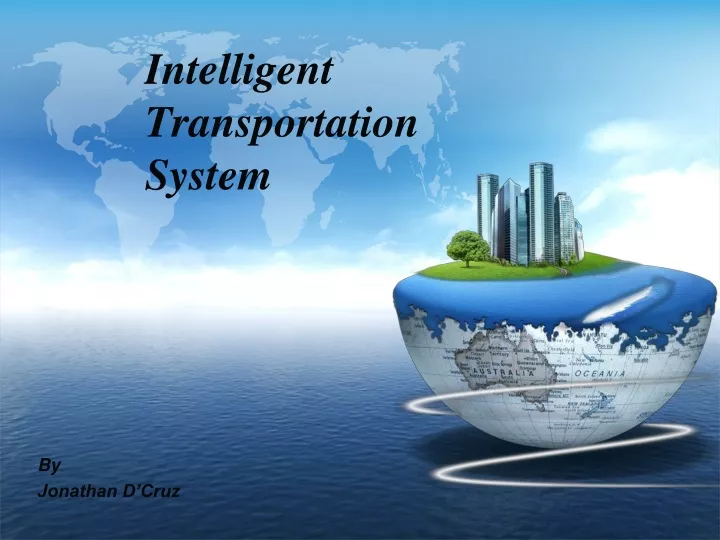
Intelligent Transportation System. By Jonathan D’Cruz. Contents. Introduction. Why ITS?. Intelligent Transport Technologies. Intelligent Transport Applications. Introduction.

E N D
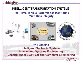
Intelligent Transportation System By Jonathan D’Cruz
Contents Introduction Why ITS? Intelligent Transport Technologies Intelligent Transport Applications
Introduction • The term Intelligent Transportation Systems (ITS) refers to information and communication technology, applied to transport infrastructure and vehicles, that improve transport outcomes such as: • Transport Safety • Transport Productivity • Travel Reliability • Informed Travel Choices • Social Equity • Environmental Performance • Network Operation Resilience
Why ITS? Interest in ITS comes from the problems caused by traffic congestionand a synergy of new information technology for simulation, real-time control, and communications networks. Traffic congestion has been increasing worldwide as a result of increased motorization, urbanization, population growth, and changes in population density. Congestion reduces efficiency of transportation infrastructure and increases travel time, air pollution, and fuel consumption. Many of the proposed ITS systems also involve surveillance of the roadways. Further, ITS can play a role in the rapid mass evacuation of people in urban centers after large casualty events such as a result of a natural disaster or threat.
Intelligent Transport Technologies Wireless Communications Inductive Loop Detection & Sensing Technologies Video Vehicle Detection Computational Technologies Floating Car Data/Floating Cellular Data
Wireless Communications Radio modem communication on UHF and VHF frequencies are widely used for short and long range communication within ITS. Short-range communications (less than 450 meters) can be accomplished using IEEE 802.11 protocols. Theoretically, the range of these protocols can be extended using Mobile ad-hoc networks or Mesh networking. Longer range communications have been proposed using infrastructure networks such as WiMAX (IEEE 802.16), Global System for Mobile Communications (GSM), or 3G.
Computational Technologies A typical vehicle in the early 2000s would have between 20 and 100 individual networked microcontroller/Programmable logic controller modules with non-real-time operating systems. The current trend is toward fewer, more costly microprocessor modules with hardware memory management and Real-Time Operating Systems. The new embedded system platforms allow for more sophisticated software applications to be implemented, including model-based process control, artificial intelligence, and ubiquitous computing. Perhaps the most important of these for Intelligent Transportation Systems is artificial intelligence.
Floating Car Data/Floating Cellular Data • "Floating car" or "probe" data collection is a set of relatively low-cost methods for obtaining travel time and speed data for vehicles traveling along streets, highways, freeways, and other transportation routes. • Broadly speaking, three methods have been used to obtain the raw data: • Triangulation Method • Vehicle Re-Identification • GPS Based Methods • Floating car data technology provides advantages over other methods of traffic measurement: • Less expensive than sensors or cameras • More coverage (potentially including all locations and streets) • Faster to set up and less maintenance • Works in all weather conditions, including heavy rain
Triangulation Method. • In the mid 2000s, attempts were made to use mobile phones as anonymous traffic probes. As a car moves, so does the signal of any mobile phones that are inside the vehicle. By measuring and analyzing network data using triangulation, pattern matching or cell-sector statistics (in an anonymous format), the data was converted into traffic flow information. • With more congestion, there are more cars, more phones, and thus, more probes. In metropolitan areas, the distance between antennas is shorter and in theory accuracy increases. • An advantage of this method is that no infrastructure needs to be built along the road; only the mobile phone network is leveraged. • By the early 2010s, the popularity of the triangulation method was declining.
Vehicle Re-identification • This method requires sets of detectors mounted along the road. In this technique, a unique serial number for a device in the vehicle is detected at one location and then detected again (re-identified) further down the road. Travel times and speed are calculated by comparing the time at which a specific device is detected by pairs of sensors. This can be done using the MAC (Machine Access Control) addresses from Bluetooth devices, or using the RFID serial numbers from Electronic Toll Collection (ETC) transponders. • GPS Based Methods. • An increasing number of vehicles are equipped with in-vehicle GPS (satellite navigation) systems that have two-way communication with a traffic data provider. Position readings from these vehicles are used to compute vehicle speeds.
Sensing Technologies Technological advances in telecommunications and information technology, coupled with state-of-the-art microchip, RFID (Radio Frequency Identification), and inexpensive intelligent beacon sensing technologies, have enhanced the technical capabilities that will facilitate motorist safety benefits for intelligent transportation systems globally. Sensing systems for ITS are vehicle- and infrastructure-based networked systems. Infrastructure sensors are indestructible devices that are installed or embedded in the road or surrounding the road, as required, and may be manually disseminated during preventive road construction maintenance or by sensor injection machinery for rapid deployment.
Inductive Loop Detection Inductive loops can be placed in a roadbed to detect vehicles as they pass through the loop's magnetic field. The simplest detectors simply count the number of vehicles during a unit of time (typically 60 seconds in the United States) that pass over the loop While more sophisticated sensors estimate the speed, length, and weight of vehicles and the distance between them. Loops can be placed in a single lane or across multiple lanes, and they work with very slow or stopped vehicles as well as vehicles moving at high-speed.
Video Vehicle Detection Traffic flow measurement and automatic incident detection using video cameras is another form of vehicle detection. Since video detection systems such as those used in automatic number plate recognition do not involve installing any components directly into the road surface or roadbed, this type of system is known as a "non-intrusive" method of traffic detection. Video from black-and-white or color cameras is fed into processors that analyze the changing characteristics of the video image as vehicles pass. The cameras are typically mounted on poles or structures above or adjacent to the roadway. Most video detection systems require some initial configuration to "teach" the processor the baseline background image. This usually involves inputting known measurements such as the distance between lane lines or the height of the camera above the roadway.
Intelligent Transport Applications Emergency Vehicle Notification Systems Automatic Road Enforcement Variable Speed Limits Collision Avoidance Systems Dynamic Traffic Light Sequence
Automatic Road Enforcement Speed cameras that identify vehicles traveling over the legal speed limit. Many such devices use radar to detect a vehicle's speed or electromagnetic loops buried in each lane of the road. Red light cameras that detect vehicles that cross a stop line or designated stopping place while a red traffic light is showing. Bus lane cameras that identify vehicles traveling in lanes reserved for buses. In some jurisdictions, bus lanes can also be used by taxis or vehicles engaged in car pooling. Level crossing cameras that identify vehicles crossing railways at grade illegally. Double white line cameras that identify vehicles crossing these lines. High-occupancy vehicle lane cameras for that identify vehicles violating HOV requirements.
Automatic speed enforcement gantry or "Lombada Eletrônica" with ground sensors at Brasilia, D.F.