Download
1 / 10
100 likes | 204 Views
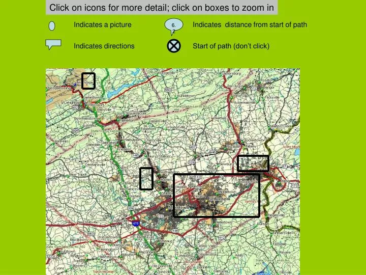
Click on icons for more detail; click on boxes to zoom in. Indicates a picture. 6.2. Indicates distance from start of path. Indicates directions. Start of path (don’t click). Click on icons for more detail; click on boxes for a larger scale M ap or another web S ite. Indicates a picture.

E N D
Click on icons for more detail; click on boxes to zoom in Indicates a picture 6.2 Indicates distance from start of path Indicates directions Start of path (don’t click)
Click on icons for more detail; click on boxes for a larger scale Map or another web Site Indicates a picture 6.2 Indicates miles from start of path Indicates travel directions Start of path (don’t click) S 2 4 6 Miles M M M
DIRECTIONS TO ALLENTOWN CANAL PARK From Allentown: Go east on Hamilton St, cross the Lehigh River, and take your left at the first traffic light at S. Bradford. Loop around under the bridge, on S. Albert to stop sign, bear right across the tracks, follow road under railroad overpass into the canal park. From Bethlehem: Go west on Broad St. and then Hanover Avenue. Go right on S. Bradford St. at first traffic light after traffic light where Hanover Ave joins Hamilton St. Loop around under the bridge, on S. Albert to sign, bear right across the tracks, follow road under railroad overpass into the canal park.
Click on icons for more detail; click on yellow boxes for a larger scale map or another web site Picture 6 Mile marker Trailhead Jim Thorpe 2 4 6 Miles Lehigh Gorge State Park NorBathTrail Palmer Path Ironton Rail Trail Easton Bethlehem Allentown Lehigh Canal towpath Designed by Edwin J. Kay
Click on icons for more detail Picture 6 Mile marker Trailhead Easton 1 2 3 14. MILES 12. 10. 8. Bethlehem 2. 6. 4. Allentown Designed by Edwin J. Kay
DIRECTIONS TO CANAL TOWPATH ON SAND ISLAND From the North: Take 378 South to exit 3. At end of ramp go left on 3rd Avenue. Proceed south to Prospect Avenue. Go left on Prospect to 2nd Avenue. Go right on 2nd Avenue to T-intersections with Spring St. Go left down the hill. Take second right on Main St. Go straight through stop sign over bridge over canal. Towpath crosses at end of bridge. From the South: Take 378 North to Main St. exit. At end of ramp go right, proceeding downhill. At bottom take left on Main St. Go straight through stop sign over bridge over canal. Towpath crosses at end of bridge. From CAT’s sumptuous headquarters on Guetter St: Go south on Guetter to Broad St. Go right. Take first left on Main St. follow Main St down the hill. At bottom take left on Main St. Go straight through stop sign over bridge over canal. Towpath crosses at end of bridge
DIRECTIONS TO CANAL PATH IN FREEMANSBURG From the west: proceed along Pembroke road, continuing straight when Freemansburg Ave bears to the left. At T-intersection at Main St. in Freemansburg, turn left. Just before railroad underpass, bear right on dirt road and enter park. From the east: proceed along Freemansburg road until it joins Pembroke Rd. Turn sharply left and follow road to T-intersection on Main St. Turn left. Just before railroad underpass, bear right on dirt road and enter park From the south. Go north on Rte 412. Take first right after Saucon Park following signs toward Steel City. After passing sewage treatment plant on right, turn left across bridge to Main St. in Freemansburg. Just before railroad underpass, bear right on dirt road and enter park
Click on icons for more detail Clickto change scale Trailhead 0.5 1 1.5 MILES
Click on a text box for a detailed map or a link to a website 7 4 3 2 5 1 6 Ironton Rail Trail Monocacy Way Palmer Path Link to Perkiomen Trail NorBath Trail Lehigh Canal Towpath Allentown Trails 1 5 4 3 2 1 2 3 Miles Easton Bethlehem 6 Allentown 7 Designed by Edwin J. Kay