Download
1 / 14
140 likes | 274 Views
Consolidated Seasonal Rainfall Guidance for Africa Dec 2012 Initial Conditions. Summary Forecast maps Forecast Background ENSO update Current State of the global climate SST Forecasts Summary. Summary.

E N D
Consolidated Seasonal Rainfall Guidance for Africa Dec 2012 Initial Conditions • Summary • Forecast maps • Forecast Background • ENSO update • Current State of the global climate • SST Forecasts • Summary
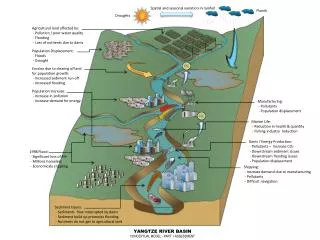
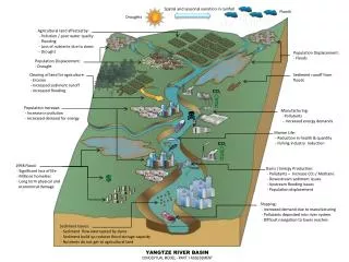
Summary • The forecasts call for slightly increased chance for above average rainfall in parts of Tanzania in Jan-Mar, Feb-Apr 2013, and the same for Malawi and Mozambique in Mar-May 2013. There is a slightly increased chance for below average rainfall along coastal Guinea in Feb-Apr 2013. • Neutral El Nino Southern Oscillation (ENSO) conditions continue to prevail • Sea surface temperatures (SSTs) in the tropical Atlantic and the Indian Ocean are slightly above normal with a tendency for cooling • SST predictions favor ENSO-neutral and most models do not predict significant departures from climatology in the global tropical oceans • Neutral ENSO conditions and weak SST anomalies in the tropical south Atlantic and in the Indian Ocean contribute to a low confidence in the precipitation forecasts for the coming seasons. • Additional forecast resources can be found here: http://www.cpc.ncep.noaa.gov/products/NMME/
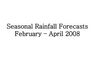
Seasonal Rainfall Guidance for Africa, Dec IC, Issued 3 Jan 2013, Valid Jan-Mar 2013, Feb-Apr 2013, Mar-May 2013 • Methodology • The consolidated outlook is subjectively derived from CCA forecasts, the NCEP Climate • Forecast System (CFS) outlooks, and current state of the global climate system and • outlooks. • Equal Chance (EC) is indicated where there is no signal in either the CFS or the CCA. • EC is also indicated where there is disagreement between the CCA and the CFS.
Seasonal Rainfall Guidance for Africa, Dec IC, Issued 3 Jan 2013, Valid Jan-Mar 2013, Feb-Apr 2013, Mar-May 2013 The forecasts call for a slightly elevated chance for above average rainfall to occur over the eastern half of Tanzania, northern Mozambique, and Malawi during Jan-Mar 2013. For Feb-Apr 2013, there is a slightly increased chance for above average rainfall over northeastern Tanzania, and slightly increased chance for below average rainfall along portions of the Gulf of Guinea coast. For Mar-May 2013, there is a slightly increased chance for above average rainfall over Malawi and northern Mozambique. Climatology is suggested everywhere else. Jan-Mar 2013, Zero Month Lead Feb-Apr 2013, One Month Lead Mar-May 2013, Two Months Lead
CPC ENSO Update • CPC ENSO Alert Status: Not Active (6 December 2012, next update 10 Jan 2013) • Synopsis:ENSO-neutral is favored for Northern Hemisphere winter 2012-13 and into spring 2013. .
Current State of the Global Ocean SST Anomaly and Tendency for December 2012 SST was near average across much of the Pacific. Slightly positive SST anomalies persisted over the central Indian Ocean Elevated SST persisted locally off the Angola coast. The change in SST anomalies is negative in the equatorial Pacific, suggesting a decrease in SST
Wind Anomaly 850hPa Winds were near average over the central Pacific. Anomalous low-level (850-hPa) easterly winds were evident across the western Pacific Ocean, converging with easterly wind anomalies over the eastern Indian Ocean. 200hPa Anomalous upper-level (200 hPa) winds were easterly over the eastern Pacific. Winds were near average over the equatorial Indian Ocean Ocean.
OLR Anomaly, December 2012 Negative OLR anomalies (enhanced convection and precipitation, blue shading) were observed over eastern Australia and Indonesia with an extension over the central Indian Ocean. Precipitation was also enhanced over southern Africa. Positive OLR anomalies (suppressed convection and precipitation, red shading) were apparent over eastern Indonesia, Papua New Guinea, and in the central Pacific. Precipitation was also suppressed over Madagascar and the southwestern Indian Ocean.
Summary of State of the Global Ocean in Dec 2012 • Neutral ENSO state continued to prevail in December. Equatorial sea surface temperatures (SST) anomalies were slightly positive across the far western tropical Pacific Ocean, neutral in the central Pacific, and slightly below normal over the eastern Pacific. • Over the past month, SST remained slightly elevated over much of the tropical Indian Ocean. However, no significant departure from Nov SST was seen. SST continued to decrease over the Mozambique Channel, where neutral conditions prevailed. Southwest Indian Ocean SST continued to decrease • In the Atlantic, SST continued to increase along coastal Angola, but decreased over the south central sector. Tropical north Atlantic continued to be warmer than normal, but a tendency for cooling in the eastern sector was observed in Dec. The same scenario prevailed for subtropical northwestern Atlantic. • Upper-level and lower-level zonal winds were near average across the central Pacific. Precipitation was near average across the eastern equatorial Pacific, slightly suppressed over the central and western sectors of the Pacific, and enhanced over the eastern and central Indian Ocean. Thus, confirming that both the atmosphere and ocean indicated ENSO-neutral conditions.
CPC/IRI Probabilistic ENSO Outlook(updated 6 Dec 2012) ENSO-neutral is favored through mid-2013. CPC ENSO Monitoring Team
Pacific Niño 3.4 SST Outlook • Most models predict either persistence or a gradual weakening of current Niño-3.4 values, with ENSO-neutral continuing through the Northern Hemisphere summer 2013. Figure provided by the International Research Institute (IRI) for Climate and Society (updated 18 Dec 2012). CPC ENSO Monitoring Team
Pacific SST Outlook: NCEP CFS.v2 Forecast Issued 30 December 2012 The CFS.v2 ensemble mean (black dashed line) predicts below-average SSTs during N. Hemisphere winter 2012-13. CPC ENSO Monitoring Team
Global SST Outlook: NCEP CFS.v2 Forecast Initial Conditions 23 Dec 2012 – 2 Jan 2013 Apr-Jun 2013 Jan-Mar 2013 Caution: Ocean areas with skill less than 0.3 are shaded in gray Feb-Apr 2013 May-Jul 2013 Mar-May 2013 CFS.v2 predicts above normal SST over the northern Indian Ocean and near Australia. Near average conditions are predicted over most areas in the central IO through the spring to early summer season Additional forecast resources are found here: http://www.cpc.ncep.noaa.gov/products/NMME/
Summary • Neutral El Nino Southern Oscillation (ENSO) conditions continue to prevail • Sea surface temperatures (SSTs) in the Atlantic and the Indian Ocean are also near normal • SST predictions favor ENSO-neutral and most models do not predict significant departures from climatology in the global tropical oceans • Neutral ENSO conditions and weak SST anomalies in the tropical south Atlantic and in the Indian Ocean contribute to a low confidence in the precipitation forecasts for the coming seasons. • Additional forecast resources can be found here: http://www.cpc.ncep.noaa.gov/products/NMME/