Download
1 / 9
90 likes | 252 Views
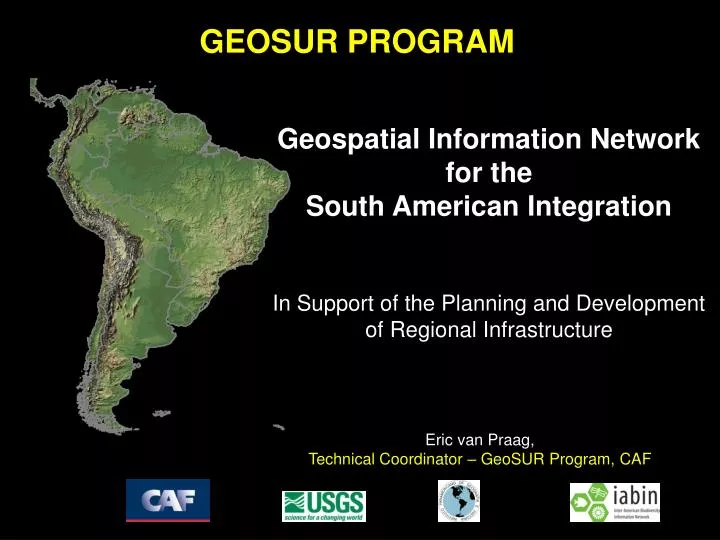
GEOSUR PROGRAM. Geospatial Information Network for the South American Integration In Support of the Planning and Development of Regional Infrastructure. Eric van Praag, Technical Coordinator – GeoSUR Program, CAF. Broad Objectives of the GeoSUR Program.

E N D
GEOSUR PROGRAM Geospatial Information Network for the South American Integration In Support of the Planning and Development of Regional Infrastructure Eric van Praag, Technical Coordinator – GeoSUR Program, CAF
Broad Objectives of the GeoSUR Program • To provide decision-makers with national and regional digital maps that facilitate the planning of physical infrastructure development and regional integration. • To facilitate and promote collaboration among national institutions in the region in order to jointly update, share, and work with geospatial information.
GeoSUR Program Profile Geographic area: The 12 South American countries and Panama Implementation period: 2007 - 2009 Participating Agencies: • National geographic institutes • Ministries of planning / infrastructure / public works • Ministries of the environment • Pan American Institute of Geography and History (PAIGH) • United States Geological Service (USGS) • Secretariat of the Inter American Biodiversity Information Network (IABIN) • Andean Development Corporation (CAF)
Related Initiatives IABIN: Development of a geospatial network for Meso America and the Caribbean (2004 – 2006). GOS: Geospatial One Stop - USA. It integrates geoportals, geoservers, catalogues, and databases in a decentralized national network. Global Map of the Americas: Planned within the framework of the Global Map project CONDOR: Andean Online GIS developed by CAF and Conservation International ... and similar initiatives in Europe, Asia and Africa
Geoportal: Geographic portal provided access to the GeoSUR online services Geoserver Network: IMS applications developed by all participating institutions Elevation derivatives: Integrated, standardized and homogeneous maps of South America derived from the SRTM DEM (res.: 30 m.) Base maps of South America: Integration of national base maps in a seamless regional maps (e.g. road network, cities, infrastructure) Geospatial catalogues: Creation of metadata and catalogues (clearinghouse) GeoSUR´s Deliverables
ArcIMS MMS MMS ArcIMS WMS WMS WMS WMS Web Server Web Server Web Server Web Server GeoSur Program - Architecture GeoIntegrator Integrates maps of use/coverage and topography of Perú and Brazil Geoserver M.A. Brazil Geoserver IGN Brazil Geoserver M.A. Perú Geoserver IGN Perú Internet Brazil Use/coverage Perú Use/coverage Perú Topography Brazil Topography
GeoSUR Implementation Phases • Stage I: Definition of concepts, dimensions, parameters, initial technological evaluation, design of the operative guidelines, alliances, initial products, presentation and agreements with the institutions involved (March, 2007). • Stage II: Gathering of information on the needs of the involved institutions, final technological evaluation, training of key teams, development of advanced functions of the geointegrator, incorporation of new geoservers, development of a 3D model of South America, development of specialized regional layers, public launch (December, 2008).
GeoPortal: Operative in a web site that uses freeware Regional Geoserver: Containing regional infrastructure information Elevation Derivatives: relief, sub-watersheds, rivers, slope and aspects of a major watershed in Ecuador GeoSURPRODUCTS STAGEI
More information: • Eric van Praag, GeoSUR Technical Coordinator, evanpraag@caf.com • Jesús Suniaga, CAF, jsuniaga@caf.com