Download
1 / 12
120 likes | 275 Views
QUANTIFYING INTERCONTINENTAL TRANSPORT THROUGH INTEGRATION OF OBSERVATIONS AND MODELS. SATELLITE OBSERVATIONS Global and continuous but few species, low resolution. Source/sink inventories. 3-D CHEMICAL TRACER MODELS. SURFACE OBSERVATIONS high resolution but spatially limited.

E N D
QUANTIFYING INTERCONTINENTAL TRANSPORTTHROUGH INTEGRATION OF OBSERVATIONS AND MODELS SATELLITE OBSERVATIONS Global and continuous but few species, low resolution Source/sink inventories 3-D CHEMICAL TRACER MODELS SURFACE OBSERVATIONS high resolution but spatially limited Assimilated meteorological data AIRCRAFT OBSERVATIONS High resolution, targeted flights provide critical snapshots for model testing Chemical and aerosol processes INTERCONTINENTAL TRANSPORT: CONCENTRATIONS AND FLUXES
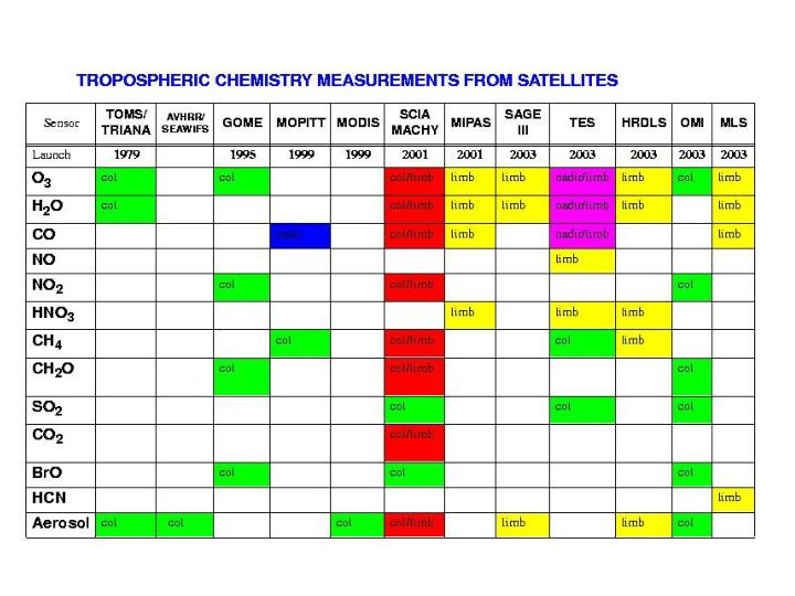
Satellite data in near-real time: MOPITT TOMS SEAWIFS AVHRR LIS TRACE-P EXECUTION Stratospheric intrusions FLIGHT PLANNING Long-range transport from Europe, N. America, Africa 3D chemical model forecasts: - ECHAM - GEOS-CHEM - Iowa/Kyushu - Meso-NH -LaRC/U. Wisconsin ASIAN OUTFLOW Boundary layer chemical/aerosol processing DC-8 P-3 PACIFIC • Emissions • Fossil fuel • Biomass burning • Biosphere, dust ASIA PACIFIC
TOMS AND SEAWIFS DATA DURING TRACE-P (3/21/01) Observations of dust, biomass burning plumes DC-8 Flight track TOMS Aerosol index SEAWIFS AOD SEAWIFS Visible image
MOPITT near-real time CO column data during TRACE-P:diamonds show validation experiments Source: J.C. Gille, NCAR MOPITT validation spirals MOPITT validation transect (following orbit track)
MOPITT validation during TRACE-P: 40N, 132W 0226 at 2005Z; double spiral bracketing in time the MOPITT overpass. Solid stratus deck with tops at 3.5Kft, otherwise clear sky. Layer at 4-7 km is aged Asian pollution. DC-8 CO data (Sachse)
RETRIEVAL OF TROPOSPHERIC NO2 FROM GOMEJuly 1996 data [Martin et al., 2001] Scattering AMF using local shape factors from the GEOS-CHEM model and accounting for local cloud information (fraction, top, optical depth) GEOS-CHEM global 3-D model with GEIA inventory for NOx (scaled to 1996)
FORMALDEHYDE COLUMNS FROM GOME:July 1996 means [Palmer et al., 2001]
GEIA BEIS2 GOME MAPPING OF ISOPRENE EMISSIONS BY SCALING OF GOME FORMALDEHYDE COLUMNS(July 1996)
SLANT FORMALDEHYDE COLUMNS FROM GOME:Isoprene “volcano” in the Ozarks [Palmer et al., 2001]
SAMPLE 500 hPa OZONE FIELD AS VIEWED BY TES GEOS-CHEM data for Aug. 15, 1994 (“real atmosphere”) …as would be retrieved by TES… (level 2 data) … and subsequently Interpolated (level 3 data)
THE LONGER-TERM PERSPECTIVE:GEOSTATIONARY OBSERVATIONS • GIFTS (2004), GEO-TRACE (proposed), GEO-SCIA (proposed) • Observe ozone, CO, NO2, HCHO, aerosols (scattering and absorbing), water vapor, clouds in nadir • Advantage: continuous observation of continental-scale scene with high spatial resolution • Resolve synoptic-scale transport, convective outflow • Resolve temporal dependence of emissions • Can be moved in space (or deployed in constellation) to provide global mapping • Disadvantages • Distant viewing (compensate by staring) • Low vertical resolution (compensate by high horizontal density of information)